Penhallam

Last updated

Penhallam
Jacobstow, Cornwall
The ruins of Penhallam Moated Manor House - geograph.org.uk - 23988.jpg
The exposed foundations
Cornwall UK location map.svg
Red pog.svg
Penhallam
Coordinates 50°44′56″N4°31′06″W / 50.74901°N 4.51831°W / 50.74901; -4.51831 Coordinates: 50°44′56″N4°31′06″W / 50.74901°N 4.51831°W / 50.74901; -4.51831
TypeFortified manor house
Site information
Controlled by English Heritage
Open to
the public
Yes
ConditionOnly foundations remain

Penhallam is the site of a fortified manor house near Jacobstow in Cornwall, England. There was probably an earlier, 11th-century ringwork castle on the site, constructed by Tryold or his son, Richard fitz Turold in the years after the Norman invasion of 1066. Their descendants, in particular Andrew de Cardinham, created a substantial, sophisticated manor house at Penhallam between the 1180s and 1234, building a quadrangle of ranges facing onto an internal courtyard, surrounded by a moat and external buildings. The Cardinhams may have used the manor house for hunting expeditions in their nearby deer park. By the 14th century, the Cardinham male line had died out and the house was occupied by tenants. The surrounding manor was broken up and the house itself fell into decay and robbed for its stone. Archaeological investigations between 1968 and 1973 uncovered its foundations, unaltered since the medieval period, and the site is now managed by English Heritage and open to visitors.

Contents

11th century

Penhallam Manor is located near Jacobstow, in a sheltered valley leading down to the sea, at the junction of two tributaries of the River Neet. [1] The valley is now a mixture of woodland and marshes, although in the medieval period it would have formed a more open area of land. [2]

There may have been an earlier Anglo-Saxon building on the site, although no traces have been found. [3] Shortly after the Norman conquest of England, however, a ringwork castle was probably built at Penhallam by the invaders, and a substantial manor was recorded as being present there in the Domesday survey of 1086. [4] [lower-alpha 1] The construction work was carried out either by a one Tryold - a follower of Robert, the Count of Mortain - or his son, Richard fitz Turold. [6] In the wake of the invasion, Robert acquired vast lands in Cornwall, and in turn the pair were granted the honour of Cardinham, a feudal landing holding comprising 28 manors. [7]

The castle at Penhallam took advantage of a raised area of ground above the marshes, with a circular bank of earth possibly up to 50 feet (15 m) wide and 12 feet (3.7 m) high, surrounded by a shallow, wet moat up to 38 feet (12 m) across. A hall would have been constructed within the ringwork, up to 60 feet (18 m) in length, possibly using stone or cobwalling. [8] A bailey probably lay just to the south, containing the stables and outbuildings, probably within the earth bank that surrounds the modern farmstead. [9]

12th-13th centuries

Diagram of the main manor house; A - brewhouse/bakehouse; B - buttery; C - hall; D - wardrobe; E - pantry; F - kitchen; G - camera; H - lodgings; I - larder: J - chapel; K - bridge and gatehouse; L - moat Diagram of Penhallam Manor.png
Diagram of the main manor house; A - brewhouse/bakehouse; B - buttery; C - hall; D - wardrobe; E - pantry; F - kitchen; G - camera; H - lodgings; I - larder: J - chapel; K - bridge and gatehouse; L - moat

Tyrold and Richard fitz Turold founded what eventually became known as the Cardinham family, who became powerful Cornish landowners and agents for the Crown. [10] Penhallam was an important manor for them, and it may have acted as their administrative caput before the family established their main castle at Cardinham. [11] The family probably visited several times a year, possibly to go hunting in the deer park they established stretching up the valleys to the south-west. [12] From around 1180 onwards, under either Robert fitz William or Robert de Cardinham, the manor house began to be redeveloped, with the ringwork defences being mostly demolished in the process. [13]

The first work involved building a camera - a chamber alongside the existing hall - and was carried out between 1180 and 1200. [14] A set of rooms known as a wardrobe, used for accommodation and storage, and a garderobe followed on the north end. [9] Robert's son, Andrew de Cardinham, inherited the family's estates around 1226 and carried on expanding Penhallam, building a new hall, a service wing - including a kitchen, buttery, pantry, and a combined brewhouse and bakehouse - a chapel, lodgings, and a gatehouse. [15] The gatehouse was protected by a drawbridge, leading to a set of stables and other service buildings on the site of the former bailey. [16] The exterior walls were whitewashed and would have made the property highly visible from the nearest road. [2] By around 1234, the result was a substantial, sophisticated manor house, with a large quadrangle of ranges, approximately 158 by 125 feet (48 by 38 m) across, facing onto an internal courtyard. [17]

Andrew gave the manor to Emma, his widowed sister-in-law, for the remainder of her life in 1234; Andrew left no male heir, and on his death the manor passed to his daughter, Isolda de Cardinham. [18] Isolda then gave the manor to Sir Henry de Champernowne, a member of a powerful Devonshire family, at some point before 1270. [19] Around this time, the drawbridge was replaced with a stone bridge and, around the end of the century, the southern kitchen and lodging buildings were rebuilt. [2]

14th-21st centuries

The bridge leading over the southern moat Penhallam Manor moat with bridge - geograph.org.uk - 714529.jpg
The bridge leading over the southern moat

By the 14th century, Penhallam was occupied by the Beaupré family, tenants of the Champernownes, and by 1330 the manor had begun to be subdivided into smaller units of land. [20] The manor house was abandoned and fell into disrepair; the roof collapsed at some point after 1360. [21] The walls were robbed for their stone and by 1428 the manor itself had ceased to exist. [22] A small farmstead, called Berry or Bury Court, was established on the site of the former stables. [23]

In the mid-20th century, plans were drawn up to clear the area around the former house, then owned by Roger Money-Kyrle and managed by Economic Forestry (South West) Ltd., in order to plant a new forest. [24] Initial archaeological investigations were carried out by the Ministry of Public Building and Works in 1968, and work continued until 1973. The foundations of the walls, exposed by the archaeologists, were consolidated and protected, and the moat cleaned out and refilled. [2] The site was protected under UK law as a scheduled monument in 1996, and is now managed by English Heritage and open to visitors. [25]

See also

Notes

  1. The existence of an 11th-century ringwork at Penhallam was first proposed by the archaeologist Guy Beresford, following his investigations at the site between 1968 and 1973. Beresford noted that the investigations had uncovered an earth bank running around the site, resembling that found at ringwork castles, which had then been destroyed prior to the 12th and 13th century construction work. No hard dating evidence for early Norman buildings could be found, but Beresford argued that this was not inconsistent with the building methods used during the period. Beresford highlighted the other ringworks known to have been constructed by the early Cardinham family during the period in the region, and the importance of the Penhallam manor during the early Norman period. Several other historians, including Anthony Emery and Ian Soulsby, have followed this analysis. Ann Preston-Jones and Peter Rose, are more cautious however, stressing the inconclusive nature of the archaeological record and describing the site as a "possible ringwork", suggesting that the ringwork castle at Week St Mary may have been used to oversee the Penhallam manor. Philip Davis describes the existence of the ringwork castle as "probable" rather than "certain". [5]

Related Research Articles

Ashby de la Zouch Castle 15th-century fortification in England

Ashby de la Zouch Castle is a ruined fortification in the town of Ashby-de-la-Zouch, Leicestershire, England. The castle was built by William, Lord Hastings, a favourite of Edward IV, after 1473, accompanied by the creation of a 3,000-acre (1,200 ha) park. Constructed on the site of an older manor house, two large towers and various smaller buildings had been constructed by 1483, when Hastings was executed by Richard, Duke of Gloucester. The Hastings family used the castle as their seat for several generations, improving the gardens and hosting royal visitors.

Kirby Muxloe Castle Fortified manor house in Kirby Muxloe, Leicestershire, England

Kirby Muxloe Castle, also known historically as Kirby Castle, is a ruined, fortified manor house in Kirby Muxloe, Leicestershire, England. William, Lord Hastings, began work on the castle in 1480, founding it on the site of a pre-existing manor house. William was a favourite of King Edward IV and had prospered considerably during the Wars of the Roses. Work continued quickly until 1483, when William was executed during Richard, Duke of Gloucester's, seizure of the throne. His widow briefly continued the project after his death but efforts then ceased, with the castle remaining largely incomplete. Parts of the castle were inhabited for a period, before falling into ruin during the course of the 17th century. In 1912, the Commissioners of Work took over management of the site, repairing the brickwork and carrying out an archaeological survey. In the 21st century, the castle is controlled by English Heritage and open to visitors.

Sulgrave Human settlement in England

Sulgrave is a village and civil parish in West Northamptonshire, England, about 5 miles (8 km) north of Brackley. The village is just south of a stream that rises in the parish and flows east to join the River Tove, a tributary of the Great Ouse.

Restormel Castle Norman castle in Cornwall, England

Restormel Castle lies by the River Fowey near Lostwithiel in Cornwall, England, UK. It is one of the four chief Norman castles of Cornwall, the others being Launceston, Tintagel and Trematon. The castle is notable for its perfectly circular design. Although once a luxurious residence of the Earl of Cornwall, the castle was all but ruined by the 16th century. It was briefly reoccupied and fought over during the English Civil War but was subsequently abandoned. It is now under the supervision of the English Heritage and open to the public.

Weeting Castle Ruined, medieval manor house in England

Weeting Castle is a ruined, medieval manor house near the village of Weeting in Norfolk, England. It was built around 1180 by Hugh de Plais, and comprised a three-storey tower, a substantial hall, and a service block, with a separate kitchen positioned near the house. A moat was later dug around the site in the 13th century. The house was not fortified, although it drew on architectural features typically found in castles of the period, and instead formed a very large, high-status domestic dwelling. It was probably intended to resemble the hall at Castle Acre Castle, owned by Hugh's feudal lord, Hamelin de Warenne.

Lydford Castle medieval castle in Devon, England

Lydford Castle is a medieval castle in the town of Lydford, Devon, England. The first castle in Lydford, sometimes termed the Norman fort, was a small ringwork built in a corner of the Anglo-Saxon fortified burh in the years after the Norman conquest of England. It was intended to help control Devon following the widespread revolt against Norman rule in 1068. The Norman fort had been abandoned by the middle of the 12th century.

Longthorpe Tower

Longthorpe Tower is a 14th-century three-storey tower in the village of Longthorpe, famous for its well-preserved set of medieval murals.

Buckton Castle was a medieval enclosure castle near Carrbrook in Stalybridge, Greater Manchester, England. It was surrounded by a 2.8-metre-wide (9 ft) stone curtain wall and a ditch 10 metres (33 ft) wide by 6 metres (20 ft) deep. Buckton is one of the earliest stone castles in North West England and only survives as buried remains overgrown with heather and peat. It was most likely built and demolished in the 12th century. The earliest surviving record of the site dates from 1360, by which time it was lying derelict. The few finds retrieved during archaeological investigations indicate that Buckton Castle may not have been completed.

Loughor Castle Medieval fortification in southwestern Wales

Loughor Castle is a ruined, medieval fortification located in the town of Loughor, Wales. The castle was built around 1106 by the Anglo-Norman lord Henry de Beaumont, during the Norman invasion of Wales. The site overlooked the River Loughor and controlled a strategic road and ford running across the Gower Peninsula. The castle was designed as an oval ringwork, probably topped by wicker fence defences, and reused the remains of the former Roman fort of Leucarum.

Bletchingley Castle

Bletchingley Castle is a ruined castle and set of earthworks partly occupied by three buildings. The Scheduled Ancient Monument is directly beside the Greensand Way below it to the south in the village of Bletchingley in Surrey. The site's tower standing from c.1170 to 1264 had a panorama from one of the narrower parts of the Greensand Ridge, which runs from mid-Kent to south-west Surrey.

Cardinham Human settlement in England

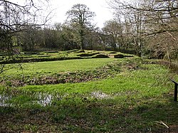
Cardinham is a civil parish and a village in mid Cornwall, England, United Kingdom. The village is situated approximately three-and-a-half miles (6 km), east-northeast of Bodmin. The hamlets of Fletchersbridge, Millpool, Milltown, Mount, Old Cardinham Castle and Welltown are in the parish.

Norbury Manor

Norbury Manor is a 15th-century Elizabethan manor house and the adjoining 13th-century stone-built medieval Norbury Hall, known as The Old Manor in Norbury near Ashbourne, Derbyshire. It is a Grade I listed building.

Richard Fitz Turold was an eleventh-century Anglo-Norman landowner in Cornwall and Devon, mentioned in the Domesday Book. In the 13th century his estates formed part of the Feudal barony of Cardinham, Cornwall, and in 1166 as recorded in the Cartae Baronum his estates had been held as a separate fiefdom from Reginald, Earl of Cornwall.

Stockport Castle

Stockport Castle was a promontory castle in Stockport, Cheshire. The castle was in the medieval town, overlooking a ford over the River Mersey. It was first documented in 1173, but the next mention of it is in 1535 when it was in ruins. What remained of the castle was demolished in 1775.

Northborough Manor House

Northborough Manor House, also known as Northborough Hall or Northborough Castle Farmhouse, is a medieval fortified manor house, and Grade I listed building in the village of Northborough in Cambridgeshire, England.

The Feudal barony of Cardinham is one of the three feudal baronies in Cornwall which existed during the medieval era. Its caput was at Cardinham Castle, Cornwall. The Barony was held in recent times by the Vivian family, the last being Nicholas Vivian, 6th Baron Vivian. Brigadier Nicholas Crespigny Laurence Vivian, 6th Baron Vivian, conveyed the title to John Anthony Vincent of Edifici Maxim's, Carrer General, Arsinal, Principat Andora, in 1995. Mr. Vincent was a member of the Manorial Society of Great Britain and died in Douglas, Isle of Man, on 31 March 2018. The Barony was then conveyed after the probate of his estate to an American citizen on 25 May 2019.

Cefnllys Historic borough in Powys, Wales

Cefnllys is an abandoned ghost village, formerly a medieval castle town and borough, near Llandrindod Wells in Radnorshire, Wales. The settlement was founded during the 13th century by the Mortimer family in order to strengthen their hold on land in the vicinity of the Cefnllys Castle, with which the town was closely associated. The town was probably intended to become the primary settlement of the lordship and cantref of Maelienydd, but was unsuccessful and declined during the 14th century as a result of bubonic plague outbreaks, economic isolation and military insecurity. Despite this, Cefnllys retained its borough status until the 19th century.

References

  1. Beresford 1974 , pp. 91–92; "Penhallam Manor", Historic Environment service of Cornwall Council, retrieved 23 December 2017
  2. 1 2 3 4 Emery 2006 , p. 614
  3. Beresford 1974 , pp. 98–99
  4. Beresford 1974 , pp. 97–98; Soulsby 1976 , p. 148
  5. Beresford 1974, p. 126; Soulsby 1976, p. 148; Emery 2006, pp. 614–615; Preston-Jones & Rose 1986, pp. 170–171; Davis, Philip, "Penhallam Manor, Jacobstow" , retrieved 24 December 2017
  6. Beresford 1974 , p. 95
  7. Beresford 1974 , p. 94; Golding, Brian (2004), "Robert, count of Mortain, (d. 1095)", Oxford Dictionary of National Biography (online ed.), Oxford University Press, doi:10.1093/ref:odnb/19339 (Subscription or UK public library membership required.)
  8. Beresford 1974 , pp. 97–100
  9. 1 2 Beresford 1974 , p. 100
  10. Beresford 1974 , pp. 94–96; "History of Penhallam Manor", English Heritage, retrieved 23 December 2017
  11. Emery 2006 , p. 614; Soulsby 1976 , p. 148
  12. Emery 2006 , p. 614; Soulsby 1976 , p. 148; Herring 2003 , pp. 38–39
  13. Beresford 1974 , pp. 95–96, 100
  14. Beresford 1974 , pp. 100–102
  15. Beresford 1974 , pp. 96, 101–102; Historic England, "Penhallam medieval moated manor house, 360m south west of Ashbury Camp (1013669)", National Heritage List for England , retrieved 23 December 2017
  16. Beresford 1974 , p. 100; Emery 2006 , p. 614; "Penhallam Manor", Historic Environment service of Cornwall Council, retrieved 23 December 2017
  17. Beresford 1974 , pp. 98, 100; Emery 2006 , p. 614; "Penhallam Manor", Historic Environment service of Cornwall Council, retrieved 23 December 2017
  18. Beresford 1974 , pp. 96, 101
  19. Beresford 1974 , pp. 96–97
  20. Beresford 1974 , pp. 96–97; "History of Penhallam Manor", English Heritage, retrieved 23 December 2017
  21. Beresford 1974 , p. 97; Emery 2006 , p. 614
  22. Beresford 1974 , pp. 92, 97
  23. Beresford 1974 , p. 90; "Cornwall & Scilly HER", Heritage Gateway, retrieved 23 December 2017
  24. Beresford 1974 , p. 127
  25. Historic England, "Penhallam medieval moated manor house, 360m south west of Ashbury Camp (1013669)", National Heritage List for England , retrieved 23 December 2017; "Penhallam Manor", Historic Environment service of Cornwall Council, retrieved 23 December 2017

Bibliography