Pilbara historical timeline

Last updated

This timeline is a selected list of events and locations of the development of the Pilbara region of Western Australia.

Contents

DateEventLocationNotes
1818Captain Phillip Parker King surveyed the coastline, naming the Intercourse Islands and Nickol Bay Dampier
1861 Francis Thomas Gregory and his party explore the Nickol Bay area, naming Port Walcott, the Hardey River, the De Grey River and the Fortescue River
April 1863Captain Peter Hedland discovers Mangrove Harbour (Port Hedland) Port Hedland
April/May 1863Charles Nairn, at the behest of his brother-in-law, pastoralist and entrepreneur Walter Padbury, establishes the first sheep station in the region. De Grey River.
May 1863Tien Tsin Harbor [ sic ] (known later as Cossack) is established Tien Tsin Harbor  [ sic ]
September 1863Sherlock Station selected by John Wellard Sherlock Station
1864Mount Welcome Station established by the Withnells Mount Welcome Station
1864Cooya Pooya Station established by Thomas Lockyer[ citation needed ] Cooya Pooya
1865Pyramid Station established by the Richardson Brothers for the Portland Squatting Company Pyramid Station
1865 (November)The first permanent government office in the region is established, headed by R. J. Sholl, Government Resident for the North District. Sholl has been relocated from the short-lived settlement at Camden Harbour  [ sic ] (on the north coast of the Kimberley). Mount Welcome/Harding River
1866On the recommendation of surveyor Charles Wedge and R.J. Sholl, the region's first townsite, named Roebourne, is gazetted, adjoining the government camp, Mt Welcome and the Harding River. Roebourne
1869Pardoo Station established as an outstation of De Grey Station Pardoo Station
1872 Copper discovered west of Whim Creek Whim Creek
1872Mundabullangana Station established by the MacKays Mundabullangana
1872Chirritta Station established by the Donald Norman McLeod. Chirritta
1878Minderoo Station established by the Forrest brothers and Septimus Burt Minderoo
1878Yarraloola Station established by the Woolhouses Yarraloola
1879Croydon Station established by the Robinsons Croydon Station
1886Yarrie Station established by Christopher Coppin Yarrie Station
1887 Gold discovered at Mallina, east of Whim Creek Mallina Station
1887First tramway opened, 2’ gauge and horse drawn, between Cossack and RoebourneRoebourne [1]
1890Gold discovered, in Coongan River bed Marble Bar
1891Emu Creek Station established Emu Creek Station
1893Marble Bar town site gazetted
1893Marronah Station established by J. H. Mansfield Maroonah
1894Cyclone kills 45 people at sea Port Hedland
1896Townsite of Port Hedland gazetted Port Hedland
1896Warrawagine Station established. Warrawagine
1898Cyclone causes £30,000 worth of damage to Cossack
1899Townsite of Nullagine gazetted Nullagine
1905Mining starts at Wodgina mine site south of Port Hedland
1906 Alfred Canning commences surveying Canning Stock Route
1909Townsite of Point Samson gazetted Point Samson
1910Canning Stock route completed droving of first cattle commences
July 1911Railway opened connecting Port Hedland with Marble Bar Marble Bar Railway
1937 Asbestos mined at Yampire Gorge, near Wittenoom Wittenoom
1938Government surveyors, Finucane and Telford, surveyed Mount Goldsworthy and reported the iron content of the ore at 65.66% with estimated reserves of more than 6,000,000 tons
1946The Pilbara Strike takes place
1950Townsite of Wittenoom gazetted Wittenoom
November 1952 Lang Hancock flies over the Pilbara region
December 1960Australian Government changes restrictions on iron ore exportsAustralia wide
March 1961Western Australian government announces that iron ore exploration permits will be allowedWestern Australia
September 1962 CRA geologists identify Mount Tom Price deposits Mount Tom Price
1964Oil was discovered in commercial quantities by West Australian Petroleum Pty Ltd Barrow Island
January 1965Dampier and Mount Tom Price - construction commences at locations
February 1965Construction commences on the town of Goldsworthy Goldsworthy
June 1965 Dampier - Tom Price railway works commence Hamersley Iron
1966 Asbestos mine closed at Wittenoom Gorge Wittenoom
1966 Rio Tinto opens its first iron ore mine in the Pilbara Mount Tom Price mine
July 1966Tom Price to Dampier - first fully loaded ore train
August 1966Dampier - first shipment of ore loaded
1967Iron ore discovered at Mount Whaleback Newman
May 1967Hamersley Holdings Limited shares on the Australian Securities Exchange
1968 BHP establishes an iron ore mine near Newman Mount Whaleback
August 1969Development of community at Karratha begins
July 1970East Intercourse Island connected by causeway
1971Townsite of Wickham gazetted Wickham
1972Cape Lambert port opened Cape Lambert
1972Townsite of Newman gazetted Newman
1972Townsite of Paraburdoo gazetted Paraburdoo
1972Townsite of Pannawonica gazetted Pannawonica
1972 Dampier Salt commences operations Dampier
1974 North West Coastal Highway from Geraldton to Port Hedland completely sealed
December 1975 Cyclone Joan - flooding in Pilbara and damages Hamersley Rail
October 1977Tom Price, Paraburdoo, Dampier and Karratha combined population passes 15,000
1978 Meekatharra to Newman section of Great Northern Highway upgraded. Great Northern Highway
1981 WAPET discovers gas off the Pilbara coast with the drilling of the Gorgon 1 well Gorgon gas project
1984North Rankin A Gas Platform commissioned North West Shelf
1989 Newman to Port Hedland section of Great Northern Highway upgraded. Great Northern Highway
1989 BHP opens iron ore mine near Newman Jimblebar mine
January 1990 Rio Tinto Group opens iron ore mine in Hamersley Range Channar mine
1992Rio Tinto opens another iron ore mine in Hamersley Range Brockman 2 mine
December 1993BHP opens another iron ore mine near Shay Gap Yarrie mine
1994Rio Tinto opens another iron ore mine in Hamersley Range Marandoo mine
1995Goodwyn A gas platform commissioned North West Shelf
2004Rio Tinto opens another iron ore mine in Hamersley Range Eastern Range mine
2006Indee Gold Mine opens at Mallina, east of Whim Creek and is closed in 2008Mallina
2007Rio Tinto opens another iron ore mine in Hamersley Range Hope Downs mine
March 2007Wittenoom townsite officially abolished by gazettal Wittenoom
October 2007 Fortescue Metals Group begins mining iron ore in the Chichester Range Cloud Break mine
April 2008First train runs on Fortescue railway Fortescue railway
June 2009Fortescue Metals Group opens new iron ore mine in the Chichester Range Christmas Creek mine
September 2010Rio Tinto opens another iron ore mine in Hamersley Range Brockman 4 mine

See also

Related Research Articles

<span class="mw-page-title-main">Pilbara Iron</span> Mining company

Pilbara Iron is a wholly owned subsidiary of the multinational Rio Tinto Group, that manages assets for Hamersley Iron Pty Ltd, a wholly owned subsidiary of Rio Tinto, and Robe River Iron Associates, an unincorporated joint venture between Rio and three Japanese steel companies Mitsui Iron Ore Development P/L (33%), Nippon Steel Australia P/L (10.5%) and Sumitomo Metal Australia P/L (3.5%).

<span class="mw-page-title-main">Karijini National Park</span> Protected area in Western Australia

Karijini National Park is an Australian national park centred in the Hamersley Ranges of the Pilbara region in the northwestern section of Western Australia. The park is located north of the Tropic of Capricorn, 1,055 kilometres (656 mi) from the state's capital city, Perth. Formerly known as Hamersley Range National Park, the park was officially renamed in 1991.

<span class="mw-page-title-main">Dampier, Western Australia</span> Town in Western Australia

Dampier is a major industrial port in the Pilbara region in the northwest of Western Australia. It is located near the city of Karratha and Port Walcott.

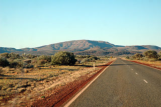
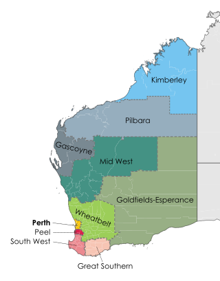
The Pilbara is a large, dry, thinly populated region in the north of Western Australia. It is known for its Aboriginal peoples; its ancient landscapes; the red earth; and its vast mineral deposits, in particular iron ore. It is also a global biodiversity hotspot for subterranean fauna.

GWR 4073 Class 4079 <i>Pendennis Castle</i>

GWR 4073 "Castle" Class No. 4079 Pendennis Castle is a 4-6-0 steam locomotive built in 1924 for the Great Western Railway (GWR) at Swindon Works to a design of Charles Collett. It was employed on long-distance express passenger trains on the GWR and its successor, British Railways' Western Region.

<span class="mw-page-title-main">Tom Price, Western Australia</span> Town in Western Australia

Tom Price is a mining town in the Pilbara region of Western Australia. It is located inland, at the edge of the Hamersley Range. Tom Price is the highest town above sea level in Western Australia, and is consequently dubbed "Top Town in WA".

<span class="mw-page-title-main">Newman, Western Australia</span> Town in Western Australia

Newman, originally named Mount Newman until 1981, is a town in the Pilbara region of Western Australia. It is located about 1,186 kilometres (737 mi) north of Perth, and 9 kilometres (5.6 mi) north of the Tropic of Capricorn. It can be reached by the Great Northern Highway. Newman is a modern mining town, with homes contrasting with the surrounding reddish desert. The 2021 population was 6,456. The Hickman Crater is 35 kilometres (22 mi) north of Newman.

Karratha is a city in the Pilbara region of Western Australia, adjoining the port of Dampier. It was established in 1968 to accommodate the processing and exportation workforce of the Hamersley Iron mining company and, in the 1980s, the petroleum and liquefied natural gas operations of the North West Shelf Venture. As of the 2021 census, Karratha had an urban population of 17,013. The city's name comes from the cattle station of the same name, which derives from a word in a local Aboriginal language meaning "good country" or "soft earth". The city is the seat of government of the City of Karratha, a local government area covering the surrounding region.

<span class="mw-page-title-main">Paraburdoo, Western Australia</span> Town in Western Australia

Paraburdoo is a mining town in the Pilbara region of Western Australia. The region is served by Paraburdoo Airport, which is situated 9 kilometres (5.6 mi) from the town.

<span class="mw-page-title-main">Hamersley Range</span> Mountain range in Western Australia

The Hamersley Range is a mountainous region of the Pilbara region of Western Australia. The range was named on 12 June 1861 by explorer Francis Thomas Gregory after Edward Hamersley, a prominent promoter of his exploration expedition to the northwest. Karijini National Park lies within the range.

The Kurrama people, also known as the Puutu Kunti Kurrama people, are an Aboriginal Australian people from the Pilbara region of Western Australia.

<span class="mw-page-title-main">Rail transport in Western Australia</span>

Railways in Western Australia were developed in the 19th century both by the Government of Western Australia and a number of private companies. Today passenger rail services are controlled by the Public Transport Authority through Transperth, which operates public transport in Perth, and Transwa, which operates country passenger services. Journey Beyond operates the Indian Pacific.

<span class="mw-page-title-main">Pilbara newspapers</span> Newspapers published in the Pilbara region of Western Australia

Pilbara newspapers is a selection of newspapers published in the Pilbara region of Western Australia.

<span class="mw-page-title-main">Hamersley & Robe River railway</span> Private railway in Pilbara region of Western Australia

The Hamersley & Robe River railway, majority-owned by Rio Tinto, and operated by its subsidiary Pilbara Iron, is a private rail network in the Pilbara region of Western Australia for the purpose of carrying iron ore. The network is larger than any other Australian heavy freight rail network in private ownership. The total length of its track is about 1,700 km (1,056 mi).

<span class="mw-page-title-main">Goldsworthy railway</span> Private railway in Pilbara region of Western Australia

The Goldsworthy railway, owned and operated by BHP, is a private rail network in the Pilbara region of Western Australia built to carry iron ore. It is one of two railway lines BHP operates in the Pilbara, the other being the Mount Newman railway.

<span class="mw-page-title-main">Mount Newman railway</span> Private railway in Pilbara region of Western Australia

The Mount Newman railway, owned and operated by BHP, is a private rail network in the Pilbara region of Western Australia built to carry iron ore. It is one of two railway lines BHP operates in the Pilbara, the other being the Goldsworthy railway.

<span class="mw-page-title-main">Brockman 2 mine</span> Iron ore mine in Western Australia

The Brockman 2 mine is an iron ore mine located in the Pilbara region of Western Australia, 60 kilometres north-west of Tom Price. It should not be confused with Rio Tinto's Brockman 4 mine, also in the area.

<span class="mw-page-title-main">Iron ore mining in Western Australia</span> Mining in Western Australia

Iron ore mining in Western Australia, in the 2018–19 financial year, accounted for 54 percent of the total value of the state's resource production, with a value of A$78.2 billion. The overall value of the minerals and petroleum industry in Western Australia was A$145 billion in 2018–19, a 26 percent increase on the previous financial year.

The Railways in the Pilbara are a collection of railways in the Pilbara region of north-west Western Australia.

<i>Hamersley News</i>

Hamersley News was a fortnightly English language newspaper published in Perth, Western Australia by Hamersley Iron Pty Ltd. It was distributed to mining communities in Dampier, Karratha, Tom Price and Paraburdoo.

References

  1. "Cossack". Hamersley News . Vol. XI, no. 3. Western Australia. 9 February 1978. p. 12. Retrieved 23 September 2023 via National Library of Australia.

Further reading