
Great Slave Lake is the second-largest lake in the Northwest Territories of Canada, the deepest lake in North America at 614 m (2,014 ft), and the tenth-largest lake in the world by area. It is 469 km (291 mi) long and 20 to 203 km wide. It covers an area of 27,200 km2 (10,500 sq mi) in the southern part of the territory. Its given volume ranges from 1,070 km3 (260 cu mi) to 1,580 km3 (380 cu mi) and up to 2,088 km3 (501 cu mi) making it the 10th or 12th largest by volume.
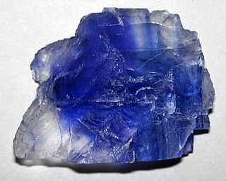
The Pine Point Mine is located on the south shore of Great Slave Lake between Hay River to the west and Fort Resolution to the east, in the Northwest Territories of Canada. It produced lead and zinc ores from a Mississippi Valley Type deposit between 1964 and 1988. Most of the mining was done by open-pit methods. The town of Pine Point was built by the mining company, Cominco, and when the mine closed the town was abandoned and demolished.

Pine Point is an abandoned locality that formerly held town status near the south shore of Great Slave Lake between the towns of Hay River and Fort Resolution in the Northwest Territories of Canada. It was built to serve the work force at the Pine Point Mine, an open-pit mine that produced lead and zinc ores. The town's population peaked at 1,915 in 1976, but was abandoned and deconstructed in 1988 after the mine closed in 1987.

Fort Resolution is a hamlet in the South Slave Region of the Northwest Territories, Canada. The community is situated at the mouth of the Slave River, on the shores of Great Slave Lake, and at the end of the Fort Resolution Highway. It is the headquarters of the Deninu Kųę́ First Nation, whose Chief is Louis Balsillie.
The Fort Resolution Highway, officially Northwest Territories Highway 6, is a highway which following the shore of Great Slave Lake from the Buffalo River Junction to Fort Resolution in Canada's Northwest Territories.
The Fort St. John Group is a stratigraphic unit of Lower Cretaceous age in the Western Canada Sedimentary Basin. It takes the name from the city of Fort St. John, British Columbia and was first defined by George Mercer Dawson in 1881.

The Redknife Formation is a stratigraphical unit of Devonian age in the Western Canadian Sedimentary Basin.
The Schooler Creek Group is a stratigraphic unit of Middle to Late Triassic age in the Western Canadian Sedimentary Basin. It is present in northeastern British Columbia. It was named for Schooler Creek, a left tributary of Williston Lake, and was first described in two oil wells northwest of Fort St. John, by F.H. McLearn in 1921. Exposures along Williston Lake serve as a type locality in outcrop.

The Horn River Formation is a stratigraphic unit of Devonian age in the Western Canadian Sedimentary Basin.
The Fort Simpson Formation is a stratigraphical unit of Devonian age in the Western Canadian Sedimentary Basin.

The Horn River is a river in the Northwest Territories of Canada. It is a major tributary of the Mackenzie River.
The Beaverhill Lake Group is a geologic unit of Middle Devonian to Late Devonian age in the Western Canada Sedimentary Basin that is present in the southwestern Northwest Territories, northeastern British Columbia and Alberta. It was named by the geological staff of Imperial Oil in 1950 for Beaverhill Lake, Alberta, based on the core from a well that they had drilled southeast of the lake, near Ryley, Alberta.
The Elk Point Group is a stratigraphic unit of Early to Middle Devonian age in the Western Canada and Williston sedimentary basins. It underlies a large area that extends from the southern boundary of the Northwest Territories in Canada to North Dakota in the United States. It has been subdivided into numerous formations, number of which host major petroleum and natural gas reservoirs.
The Woodbend Group is a stratigraphical unit of Frasnian age in the Western Canadian Sedimentary Basin.
The Tetcho Formation is a stratigraphical unit of Famennian age in the Western Canadian Sedimentary Basin.
The Kotcho Formation is a stratigraphical unit of middle Famennian age in the Western Canadian Sedimentary Basin.
The Besa River Formation is a stratigraphical unit of Devonian age in the Western Canadian Sedimentary Basin.
The Slave Point Formation is a stratigraphical unit of Middle Devonian age in the Western Canadian Sedimentary Basin.
The Nahanni Formation is a stratigraphical unit of Givetian age in the Western Canadian Sedimentary Basin.

The Taltson River is a roughly 500 km (310 mi) river in the Northwest Territories of Canada that drains into the Great Slave Lake. There are three hydroelectric power control structures on the river, and one power station.