Pine Point, Northwest Territories

Last updated

Pine Point
Abandoned locality/former town
Pine Point, Northwest Territories, Canada -2.png
Pine Point, Northwest Territories, Canada
NWT All Region Locator.svg
Red pog.svg
Pine Point
Canada location map 2.svg
Red pog.svg
Pine Point
Coordinates: 60°50′0″N114°28′5″W / 60.83333°N 114.46806°W / 60.83333; -114.46806 [1]
CountryCanada
Territory Northwest Territories
Region South Slave Region
Census division Region 5
Constructed1962 [2]
Incorporated (town)April 1, 1974 [3]
DissolvedJanuary 1, 1996 [4]
Government
  TypeUnincorporated (previously mayor-council government)
  Final mayorMichael Lenton [5]
Time zone UTC−07:00 (MST)
  Summer (DST) UTC−06:00 (MDT)

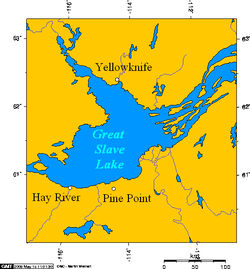
Pine Point is an abandoned locality that formerly held town status near the south shore of Great Slave Lake between the towns of Hay River and Fort Resolution in the Northwest Territories of Canada. It was built to serve the work force at the Pine Point Mine, an open-pit mine that produced lead and zinc ores. The town's population peaked at 1,915 in 1976, but was abandoned and deconstructed in 1988 after the mine closed in 1987.

Contents

History

A huge laydown of drillcore from 25 years of exploration work that defined 50 lead-zinc deposits at Pine Point. Acres of drill cores at the Pine Point lead-zinc mine, NWT.jpg
A huge laydown of drillcore from 25 years of exploration work that defined 50 lead-zinc deposits at Pine Point.

Construction of both the Pine Point mine and the community commenced in 1962. [2] Pine Point incorporated as a town on April 1, 1974. [3]

The mine was closed in 1987, forcing the single-industry town to close in 1988. [3] Mike Lenton was the town's last mayor. [5] Pine Point houses were sold cheaply, and many of the buildings were then moved to Fort Resolution (including the ice arena), Hay River and northern Alberta while the remaining buildings were demolished. [6] The Town of Pine Point was absorbed into Unorganized Fort Smith on January 1, 1996. [4] Today the site is completely abandoned, although there is still evidence of the street layout. [6]

Pine Point is the subject of Welcome to Pine Point , a 2011 web documentary created by Michael Simons and Paul Shoebridge and produced by the National Film Board of Canada. [7] The web documentary includes audiovisual material and mementos compiled by former resident Richard Cloutier for his own website, Pine Point Revisited. [8] [9]

The song "Pine Point" by the Toronto, Ontario band PUP, is a non-fictional story about the town.

Demographics

Federal census population history of Pine Point
YearPop.±%
19611    
1966459+45800.0%
19711,225+166.9%
19761,915+56.3%
19811,861−2.8%
19861,558−16.3%
1991 9−99.4%
Source: Statistics Canada
[10] [11] [12] [13] [14] [15]

As an unincorporated place, Pine Point's population was first recorded by Statistics Canada as 459 in 1966, an increase from a 1961 population of only 1. [10] It then grew to a population of 1,225 in the 1971 census. [11] By 1976, Pine Point held town status and reached a peak population of 1,915. [12] The town's population slightly declined to 1,861 by 1981 [13] and then declined further to 1,558 by 1986. [14] The population exodus that followed closure of the mine left a population of only 9 in 1991. [13]

Education

Pine Point had two schools – Galena Heights Elementary School (grades K-6) and Matonabbee School (grades 7-12). Matonabbee School burned down on February 1, 1980, after which was replaced by a new building in the same location. The last graduating class was in 1988 after the mine's closure.

Places of worship

Transportation

Pine Point was along the Fort Resolution Highway, [1] and the Mackenzie Northern Railway, which was owned by the Canadian National Railway.[ citation needed ] Ore concentrates from the mine were moved south by the railroad.[ citation needed ] The town also had a small airport.[ citation needed ]

Notable people

Further reading

Related Research Articles

<span class="mw-page-title-main">Northwest Territories</span> Territory of Canada

The Northwest Territories is a federal territory of Canada. At a land area of approximately 1,144,000 km2 (442,000 sq mi) and a 2016 census population of 41,790, it is the second-largest and the most populous of the three territories in Northern Canada. Its estimated population as of 2023 is 45,668. Yellowknife is the capital, most populous community, and only city in the territory; its population was 19,569 as of the 2016 census. It became the territorial capital in 1967, following recommendations by the Carrothers Commission.

<span class="mw-page-title-main">Whatì</span> First Nation in Northwest Territories, Canada

Whatì, officially the Tłı̨chǫ Community Government of Whatì is a First Nations community in the North Slave Region of the Northwest Territories, Canada. Whatì is located by Lac La Martre, about 164 km (102 mi) northwest of the territorial capital of Yellowknife.

<span class="mw-page-title-main">Yellowknife</span> Capital city of the Northwest Territories, Canada

Yellowknife is the capital, largest community, and only city in the Northwest Territories, Canada. It is on the northern shore of Great Slave Lake, about 400 km (250 mi) south of the Arctic Circle, on the west side of Yellowknife Bay near the outlet of the Yellowknife River.

<span class="mw-page-title-main">Fort Chipewyan</span> Hamlet in Alberta, Canada

Fort Chipewyan, commonly referred to as Fort Chip, is a hamlet in northern Alberta, Canada, within the Regional Municipality (RM) of Wood Buffalo. It is located on the western tip of Lake Athabasca, adjacent to Wood Buffalo National Park, approximately 223 kilometres (139 mi) north of Fort McMurray.

<span class="mw-page-title-main">Hay River, Northwest Territories</span> Town in Northwest Territories, Canada

Hay River, known as "the Hub of the North", is a town in the Northwest Territories, Canada, located on the south shore of Great Slave Lake, at the mouth of the Hay River. The town is separated into two sections, a new town and an old town with the Hay River/Merlyn Carter Airport between them. The town is in the South Slave Region, and along with Fort Smith, the town is home to one of the two regional offices.

<span class="mw-page-title-main">Fort Smith, Northwest Territories</span> Town in Northwest Territories, Canada

Fort Smith is a town in the South Slave Region of the Northwest Territories (NWT), Canada. It is located in the southeastern portion of the Northwest Territories, on the Slave River and adjacent to the Alberta border along the 60th parallel north.

<span class="mw-page-title-main">Fort Simpson</span> Village in Northwest Territories, Canada

Fort Simpson is a village, the only one in the entire territory, in the Dehcho Region of the Northwest Territories, Canada. The community is located on an island at the confluence of the Mackenzie and Liard rivers. It is approximately 500 km (310 mi) west of Yellowknife. Both rivers were traditionally trade routes for the Hudson's Bay Company and the native Dene people of the area.

<span class="mw-page-title-main">Crowsnest Pass, Alberta</span> Specialized municipality in Alberta, Canada

The Municipality of Crowsnest Pass is a specialized municipality in southwest Alberta, Canada. Within the Rocky Mountains adjacent to the eponymous Crowsnest Pass, the municipality formed as a result of the 1979 amalgamation of five municipalities – the Village of Bellevue, the Town of Blairmore, the Town of Coleman, the Village of Frank, and Improvement District No. 5, which included the Hamlet of Hillcrest and numerous other unincorporated communities.

<span class="mw-page-title-main">Exshaw</span> Hamlet in Alberta, Canada

Exshaw is a hamlet in Alberta, Canada within Municipal District (MD) of Bighorn No. 8. Located approximately 90 kilometres (56 mi) west of downtown Calgary and 15 kilometres (9.3 mi) east of Canmore, Exshaw is situated within the Bow River valley north of the Bow River.

<span class="mw-page-title-main">Fort Resolution</span> Hamlet in Northwest Territories, Canada

Fort Resolution is a hamlet in the South Slave Region of the Northwest Territories, Canada. The community is situated at the mouth of the Slave River, on the shores of Great Slave Lake, and at the end of the Fort Resolution Highway. It is the headquarters of the Deninu Kųę́ First Nation, whose Chief is Louis Balsillie.

<span class="mw-page-title-main">Fort Providence</span> Hamlet in Northwest Territories, Canada

Fort Providence is a hamlet in the South Slave Region of the Northwest Territories, Canada. Located west of Great Slave Lake, it has all-weather road connections by way of the Yellowknife Highway branch off the Mackenzie Highway, and the Deh Cho Bridge opened November 30, 2012, near Fort Providence over the Mackenzie. The bridge replaced the ice bridge and ferry, enabling year-round crossing of the river.

<span class="mw-page-title-main">Norman Wells</span> Town in Northwest Territories, Canada

Norman Wells is a town located in the Sahtu Region, Northwest Territories, Canada. The town, which hosts the Sahtu Regional office, is situated on the north side of the Mackenzie River and provides a view down the valley of the Franklin and Richardson mountains.

<span class="mw-page-title-main">Sambaa K'e</span> Place in Northwest Territories, Canada

Sambaa K'e is a "Designated Authority" in the Dehcho Region of the Northwest Territories, Canada. The community is located near the Alberta border, east of Fort Liard, on the shore of the lake also known as Sambaa K'e. It has no all-weather road, but can be reached by winter road early in the year or by air year-round.

<span class="mw-page-title-main">Behchokǫ̀</span> Community in Northwest Territories, Canada

Behchokǫ̀, officially the Tłı̨chǫ Community Government of Behchokǫ̀, is a community in the North Slave Region of the Northwest Territories, Canada. Behchokǫ̀ is located on the Yellowknife Highway, on the northwest tip of Great Slave Lake, approximately 110 km (68 mi) northwest of Yellowknife.

<span class="mw-page-title-main">Langdon, Alberta</span> Hamlet in Alberta, Canada

Langdon is a hamlet in southern Alberta, Canada under the jurisdiction of Rocky View County. It previously held village status between August 31, 1907, and January 1, 1946.

<span class="mw-page-title-main">Nordegg</span> Hamlet in Alberta, Canada

Nordegg is a hamlet in west-central Alberta, Canada within Clearwater County. It is in the North Saskatchewan River valley in the foothills of the Canadian Rockies, just east of the intersection of the David Thompson Highway and the Highway 734 spur of the Bighorn Highway. A former coal mining town, it was named after Martin Nordegg and the name probably means "North Corner" in a German dialect. The railway station name at the locality was called Brazeau rather than Nordegg at certain points in its history, but the local post office has always been named Nordegg. The name Brazeau is now obsolete.

La Crete, also spelled La Crête, is a hamlet in northern Alberta, Canada, within Mackenzie County. It is located on Highway 697, approximately 57 kilometres (35 mi) southeast of High Level and 701 kilometres (436 mi) north of Edmonton.

<span class="mw-page-title-main">Délı̨nę</span> Charter Community in Northwest Territories, Canada

The Charter Community of Délı̨nę is located in the Sahtu Region of the Northwest Territories, Canada, on the western shore of Great Bear Lake and is 544 km (338 mi) northwest of Yellowknife. Délı̨nę means "where the waters flow", a reference to the headwaters of the Great Bear River, Sahtúdé. It is the only settlement on the shores of Great Bear Lake as Fort Confidence was last used in the 1800s and Port Radium closed in 1982.

Cardiff is a hamlet in central Alberta, Canada within Sturgeon County. It is located 3 kilometres (1.9 mi) east of Highway 2, approximately 15 kilometres (9.3 mi) north of Edmonton's city limits. The Town of Morinville is 1.6 kilometres (0.99 mi) to the west of Cardiff.

References

  1. 1 2 "Pine Point". Geographical Names Data Base . Natural Resources Canada . Retrieved July 4, 2022.
  2. 1 2 Bone, Robert M. (September 1988). "Resource Towns in the Mackenzie Basin" (PDF). Cahiers de Géographie du Québec. University of Saskatchewan: Érudit. 42: 249–259. doi: 10.7202/022739ar . Retrieved 18 January 2016.
  3. 1 2 3 "Gazetteer of the Northwest Territories". Northwest Territories Education, Culture and Employment. January 2017. p. 8. Retrieved July 4, 2022.
  4. 1 2 "Interim List of Changes to Municipal Boundaries, Status and Names: January 2, 1991 to January 1, 1996" (PDF). Statistics Canada. February 1997. Retrieved July 3, 2022.
  5. 1 2 "People_of_Pine_Point3". pinepointrevisited.homestead.com. Retrieved 2016-01-19.
  6. 1 2 Keeling, Arn; Sandlos, John (2012). Claiming the New North: Development and Colonialism at the Pine Point Mine, Northwest Territories, Canada (PDF). Faculty of Arts (Report). Memorial University of Newfoundland. ISSN   1752-7023.
  7. Anderson, Kelly (26 January 2011). "NFB announces new web doc". Realscreen. Retrieved 3 February 2011.
  8. Quenneville, Guy (31 January 2011). "Remembering a lost mining town". Northern News Services . Archived from the original on 18 March 2011. Retrieved 1 February 2011.
  9. MacKie, John (14 April 2011). "Lost northern town is back, on the Net". Vancouver Sun . Archived from the original on 31 May 2011. Retrieved 14 April 2011.
  10. 1 2 "Population of unincorporated places of 50 persons and over, 1966 and 1961 (Alberta)". Census of Canada 1966: Population (PDF). Special Bulletin: Unincorporated Places. Vol. Bulletin S–3. Ottawa: Dominion Bureau of Statistics. August 1968. Retrieved December 5, 2021.
  11. 1 2 "Population of Unincorporated Places of 50 persons and over, 1971 and 1966 (Alberta)". 1971 Census of Canada: Population (PDF). Special Bulletin: Unincorporated Settlements. Vol. Bulletin SP—1. Ottawa: Statistics Canada. March 1973. Retrieved December 5, 2021.
  12. 1 2 "1976 Census of Canada: Population - Geographic Distributions" (PDF). Statistics Canada. June 1977. Retrieved February 1, 2022.
  13. 1 2 3 "1981 Census of Canada: Census subdivisions in decreasing population order" (PDF). Statistics Canada. May 1992. Retrieved February 1, 2021.
  14. 1 2 "1986 Census: Population - Census Divisions and Census Subdivisions" (PDF). Statistics Canada. September 1987. Retrieved February 1, 2022.
  15. "91 Census: Census Divisions and Census Subdivisions - Population and Dwelling Counts" (PDF). Statistics Canada. April 1992. Retrieved February 1, 2022.
  16. 1 2 "Photos_of_Pine4". pinepointrevisited.homestead.com. Retrieved 2016-01-19.
  17. "People_of_Pine_Point8". pinepointrevisited.homestead.com. Retrieved 2016-01-19.
  18. "Klippert v. The Queen". Supreme Court of Canada. November 7, 1967. Retrieved July 3, 2022.
  19. "Hometown Sanderson". Sports Illustrated . October 28, 1999. Archived from the original on August 18, 2000. Retrieved April 5, 2013.