Pleasant Hill, Tennessee

Last updated
Pleasant Hill, Tennessee
Pleasant-Hill-town-hall-tn1.jpg
Pleasant Hill Town Hall
Cumberland County Tennessee Incorporated and Unincorporated areas Pleasant Hill Highlighted 4759240.svg
Location of Pleasant Hill in Cumberland County, Tennessee.
Coordinates: 35°58′37″N85°12′1″W / 35.97694°N 85.20028°W / 35.97694; -85.20028
Country United States
State Tennessee
County Cumberland
Incorporated1903 [1]
Area
[2]
  Total1.64 sq mi (4.25 km2)
  Land1.63 sq mi (4.22 km2)
  Water0.01 sq mi (0.03 km2)
Elevation
[3]
1,893 ft (577 m)
Population
 (2020) [4]
  Total540
  Density331.29/sq mi (127.91/km2)
Time zone UTC-6 (Central (CST))
  Summer (DST) UTC-5 (CDT)
ZIP code
38578
Area code 931
FIPS code 47-59240 [5]
GNIS feature ID1297846 [3]

Pleasant Hill is a town in Cumberland County, Tennessee, United States. The population was 563 at the 2010 census.

Contents

History

Pleasant Hill was first settled by European Americans before 1819. [6] In 1884 a teacher from the American Missionary Association (AMA) established the Pleasant Hill Academy to provide broad liberal arts education for rural youth, while also giving vocational training in agriculture and local skills. [7] Supported by the Congregational Church, the school operated until 1947. [8] Its main building, Pioneer Hall, is still standing.

The Pleasant Hill Academy (now Pioneer Hall) Pioneer-hall-museum-tn1.jpg
The Pleasant Hill Academy (now Pioneer Hall)

May Cravath Wharton, an early woman physician from Minnesota, established a medical clinic at the academy, where her husband was the director. [7] Wharton also cared for people in the community. They invited her to stay after the death of her husband Edwin. [7]

Wharton created a small hospital and, with successful fundraising in New England through the AMA, she was able to add a sanatorium annex for the care of people with tuberculosis. As no antibiotic was known at the time, rest and good nutrition were the only treatment. The Uplands Sanatorium was adapted as a retirement home when the hospital was relocated to Crossville, the county seat. The hospital is now known as the Cumberland Medical Center. [7]

Camp Crossville, a site just east of Pleasant Hill, was used as a prisoner of war camp during World War II, housing German and Italian officers from November 1942 until the end of the war. [9]

Geography

Pleasant Hill is located at 35°58′37″N85°12′1″W / 35.97694°N 85.20028°W / 35.97694; -85.20028 (35.976915, -85.200229). [10] The town is situated in a hilly area along the western Cumberland Plateau. In the northwestern part of the town, Frey Branch is impounded by two dams, Lake Laura Dam and Lake Alice Dam, to create two small lakes, Upland Lake and Lake Alice, respectively.

U.S. Route 70 passes through the southern portion of Pleasant Hill, connecting the town with Crossville to the east and Sparta to the west.

According to the United States Census Bureau, the town has a total area of 1.6 square miles (4.1 km2), of which 1.5 square miles (3.9 km2) is land and 0.64% is water.

Demographics

Historical population
CensusPop.Note
1910 227
1920 148−34.8%
1930 16511.5%
1940 1787.9%
1950 152−14.6%
1960 26775.7%
1970 2939.7%
1980 37126.6%
1990 49433.2%
2000 54410.1%
2010 5633.5%
2020 540−4.1%
Sources: [11] [12] [4]

As of the census [5] of 2000, there were 544 people, 273 households, and 143 families residing in the town. The population density was 350.0 inhabitants per square mile (135.1/km2). There were 314 housing units at an average density of 202.0 per square mile (78.0/km2). The racial makeup of the town was 98.53% White, 0.37% African American, 0.55% Native American, 0.18% Asian, and 0.37% from two or more races. Hispanic or Latino of any race were 0.18% of the population.

There were 273 households, out of which 11.0% had children under the age of 18 living with them, 46.2% were married couples living together, 5.5% had a female householder with no husband present, and 47.3% were non-families. 45.8% of all households were made up of individuals, and 40.7% had someone living alone who was 65 years of age or older. The average household size was 1.77 and the average family size was 2.40.

In the town, the population was spread out, with 11.2% under the age of 18, 2.4% from 18 to 24, 11.2% from 25 to 44, 11.4% from 45 to 64, and 63.8% who were 65 years of age or older. The median age was 72 years. For every 100 females, there were 64.8 males. For every 100 females age 18 and over, there were 58.9 males.

The median income for a household in the town is $29,554, and the median income for a family was $37,375. Males had a median income of $23,750 versus $20,250 for females. The per capita income for the town was $21,384. About 7.0% of families and 10.9% of the population were below the poverty line, including 30.0% of those under age 18 and 5.5% of those age 65 or over.

Notable people

Further reading

Related Research Articles

<span class="mw-page-title-main">Clay County, Tennessee</span> County in Tennessee, United States

Clay County is a county in the U.S. state of Tennessee. As of the 2020 census, the population was 7,581. Its county seat and only incorporated city is Celina. Clay County is named in honor of American statesman Henry Clay, member of the United States Senate from Kentucky and United States Secretary of State in the 19th century.

<span class="mw-page-title-main">Smith County, Tennessee</span> County in Tennessee, United States

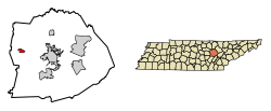
Smith County is a county in the U.S. state of Tennessee. As of the 2020 census, the population was 19,904. Smith County is located in the region of the state known as Middle Tennessee. Its county seat is Carthage. The county was organized in 1799 and is named for Daniel Smith, a Revolutionary War veteran who made the first map of Tennessee and served as a United States senator.

<span class="mw-page-title-main">Pickett County, Tennessee</span> County in Tennessee, United States

Pickett County is a county located in the U.S. state of Tennessee. As of the 2020 census, the population was 5,001, making it the least populous county in Tennessee. Its county seat is Byrdstown. The city of Byrdstown and the Kentucky town of Albany, 11 miles (18 km) to the northeast, are positioned between two Army Corps of Engineers lakes: Dale Hollow Lake, mainly in Tennessee, and Lake Cumberland, in Kentucky. The area is known as "Twin Lakes" and Byrdstown is noted as "The Gateway To Dale Hollow Lake". Every year thousands of people vacation at the many resorts situated along the lakes.

<span class="mw-page-title-main">Cumberland County, Tennessee</span> County in Tennessee, United States

Cumberland County is a county located in the U.S. state of Tennessee. As of the 2020 census, the population was 61,145. Its county seat is Crossville. Cumberland County comprises the Crossville, TN micropolitan statistical area.

<span class="mw-page-title-main">Cheatham County, Tennessee</span> County in Tennessee, United States

Cheatham County is a county located in the U.S. state of Tennessee. As of the 2020 census, the population was 41,072. Its county seat is Ashland City. Cheatham County is part of the Nashville-Davidson–Murfreesboro–Franklin, TN Metropolitan Statistical Area. It is located in Middle Tennessee.

<span class="mw-page-title-main">Crossville, Alabama</span> Town in Alabama, United States

Crossville is a town in DeKalb County, Alabama, United States. At the 2010 census the population was 1,862, up from 1,431 in 2000. Crossville is located atop Sand Mountain, a southern extension of the Cumberland Plateau.

<span class="mw-page-title-main">Indian Creek, Illinois</span> Village in Illinois, United States

Indian Creek is a village in Vernon Township, Lake County, Illinois, United States. It is part of the Chicago metropolitan area. Per the 2020 census, the population was 536. Police services are provided by Lake County Sheriff and fire/EMS services by the Countryside Fire Protection District.

<span class="mw-page-title-main">Cumberland, Kentucky</span> City in Kentucky, United States

Cumberland is a home rule-class city in Harlan County, Kentucky, in the United States. The population according to the 2010 Census was 2,237, down from 2,611 at the 2000 census.

<span class="mw-page-title-main">Grand Rivers, Kentucky</span> City in Kentucky, United States

Grand Rivers is a home rule-class city in Livingston County, Kentucky, in the United States. The population was 382 at the 2010 census, up from 343 in 2000. It is part of the Paducah micropolitan area.

<span class="mw-page-title-main">Ashland City, Tennessee</span> Town in Tennessee, United States

Ashland City is a town in and the county seat of Cheatham County, Tennessee, United States. The population was 5,193 as of the 2020 census.

<span class="mw-page-title-main">Celina, Tennessee</span> City in Tennessee, United States

Celina is a city in and the county seat of Clay County, Tennessee, United States. The population was 1,495 at the 2010 census.

<span class="mw-page-title-main">Crab Orchard, Tennessee</span> City in Tennessee, United States

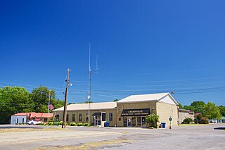
Crab Orchard is a city in Cumberland County, Tennessee, United States. The population was 719 at the 2020 census.

<span class="mw-page-title-main">Crossville, Tennessee</span> City in Tennessee, United States

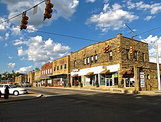
Crossville is a city in and the county seat of Cumberland County, Tennessee, United States. It is part of the Crossville Micropolitan Statistical Area. The population was 12,071 at the 2020 census.

Fairfield Glade is a resort, retirement community and census-designated place (CDP) in Cumberland County, Tennessee, United States. The population was 9,152 at the 2020 census, up over 3,000 from the 2010 census.

<span class="mw-page-title-main">Jamestown, Tennessee</span> City in Tennessee, United States

Jamestown is a city in and the county seat of Fentress County, Tennessee, United States. The population of the city was 1,959 at the 2010 census.

<span class="mw-page-title-main">Jasper, Tennessee</span> Town in Marion County, Tennessee

Jasper is a town in and the county seat of Marion County, Tennessee, United States. The population was 3,612 at the 2020 census. The town was formed in 1820 from lands acquired from Betsy Pack (1770–1851), daughter of Cherokee Chief John Lowery. Jasper is part of the Chattanooga, TN–GA Metropolitan Statistical Area.

<span class="mw-page-title-main">Sunbright, Tennessee</span> City in Tennessee, United States

Sunbright is a city in Morgan County, Tennessee, United States. The population was 552 at the 2010 census.

<span class="mw-page-title-main">Monterey, Tennessee</span> Town in Tennessee, United States

Monterey is a town in Putnam County, Tennessee, United States. The population was 2,850 at the 2010 census. It is part of the Cookeville, Tennessee Micropolitan Statistical Area.

<span class="mw-page-title-main">Carthage, Tennessee</span> Town in Tennessee, United States

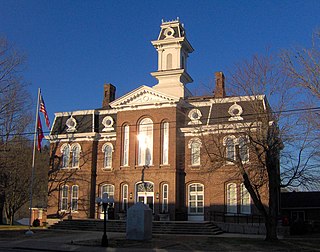
Carthage is a town in and the county seat of Smith County, Tennessee, United States; it is part of the Nashville Metropolitan Statistical Area. The population was 2,306 at the 2010 census. It is located on the Cumberland River, which was important to its early development. It is likely best known as the hometown of former Vice President and Senator Al Gore of the Democratic Party and his father, Senator Albert Gore, Sr. The younger Gore announced his 1988 and 2000 presidential bids, as well as his 1992 vice-presidential bid, from the steps of the Smith County Courthouse.

<span class="mw-page-title-main">Plattsburgh (town), New York</span> Town in New York, United States

Plattsburgh is a town in Clinton County, New York, United States. The population was 11,886 at the 2020 census. The town is named after Zephaniah Platt, an early land owner, and it surrounds the separate and more populous city of the same name. The town is in the eastern part of the county, in the North Country region of the state of New York. The region's airport, Plattsburgh International Airport, is located in the southern part of the town.

References

  1. Tennessee Blue Book , 2005-2006, pp. 618-625.
  2. "ArcGIS REST Services Directory". United States Census Bureau. Retrieved October 15, 2022.
  3. 1 2 U.S. Geological Survey Geographic Names Information System: Pleasant Hill, Tennessee
  4. 1 2 "Census Population API". United States Census Bureau. Retrieved Oct 15, 2022.
  5. 1 2 "U.S. Census website". United States Census Bureau . Retrieved 2008-01-31.
  6. Brief History of the County, Cumberland County Sesquicentennial website, accessed August 24, 2008
  7. 1 2 3 4 5 Franklin & Betty J. Parker, "Wharton, May Cravath (1873-1959)", Tennessee Encyclopedia of History & Culture, Ed. by Carroll Van West, et al. Nashville: Tennessee Historical Society, 1998, pp. 1050-1051, accessed 4 February 2011
  8. Guide to Manuscript Materials on Microfilm : MF. 1812, Tennessee State Library and Archives
  9. "Cumberland County Historic Sites", Tennessee Genealogy and History: TNGenWeb Project
  10. "US Gazetteer files: 2010, 2000, and 1990". United States Census Bureau. 2011-02-12. Retrieved 2011-04-23.
  11. "Census of Population and Housing: Decennial Censuses". United States Census Bureau . Retrieved 2012-03-04.
  12. "Incorporated Places and Minor Civil Divisions Datasets: Subcounty Resident Population Estimates: April 1, 2010 to July 1, 2012". Population Estimates. U.S. Census Bureau. Archived from the original on 11 June 2013. Retrieved 11 December 2013.
  13. Paula Bennett, Nineteenth-century American Women Poets: An Anthology, Wiley-Blackwell, 1998, pp. 351-352, accessed 3 February 2011
  14. Earl Webb stranded in Tennessee home