Potter Lake, Wisconsin

Last updated

Potter Lake, Wisconsin
CDP
WIMap-doton-Potter Lake.png
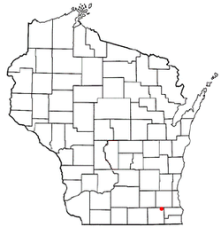
Location of Potter Lake, Wisconsin
Coordinates: 42°49′18″N88°20′56″W / 42.82167°N 88.34889°W / 42.82167; -88.34889
Country United States
State Wisconsin
County Walworth
Area
  Total1.294 sq mi (3.35 km2)
  Land1.052 sq mi (2.72 km2)
  Water0.242 sq mi (0.63 km2)
Elevation
[1]
846 ft (258 m)
Population
 (2020)
  Total1,117
  Density860/sq mi (330/km2)
Time zone UTC-6 (Central (CST))
  Summer (DST) UTC-5 (CDT)
Area code 262
FIPS code 55-64700 [2]
GNIS feature ID1867664 [1]

Potter Lake is a census-designated place (CDP) in the town of East Troy, Walworth County, Wisconsin, United States. The population was 1,117 at the 2020 census. [3]

Contents

Geography

Potter Lake is located at 42°49′18″N88°20′56″W / 42.82167°N 88.34889°W / 42.82167; -88.34889 (42.821598, -88.348858). [4]

According to the United States Census Bureau, the CDP has a total area of 1.3 square miles (3.4 km2), of which, 1.1 square miles (2.7 km2) of it is land and 0.2 square miles (0.6 km2) of it (18.70%) is water.

Demographics

Historical population
CensusPop.Note
2000 1,099
2010 1,1070.7%
2020 1,1170.9%
U.S. Decennial Census [5]

As of the census [2] of 2000, there were 1,099 people, 415 households, and 331 families residing in the CDP. The population density was 779.9 people per square mile (300.9/km2). There were 460 housing units at an average density of 326.4/sq mi (126.0/km2). The racial makeup of the CDP was 98.27% White, 0.18% African American, 0.09% Native American, 0.09% Asian, 0.36% from other races, and 1.00% from two or more races. Hispanic or Latino of any race were 0.82% of the population.

There were 415 households, out of which 34.9% had children under the age of 18 living with them, 72.0% were married couples living together, 4.3% had a female householder with no husband present, and 20.2% were non-families. 17.1% of all households were made up of individuals, and 4.1% had someone living alone who was 65 years of age or older. The average household size was 2.65 and the average family size was 2.98.

In the CDP, the population was spread out, with 24.4% under the age of 18, 6.6% from 18 to 24, 30.7% from 25 to 44, 29.5% from 45 to 64, and 8.8% who were 65 years of age or older. The median age was 40 years. For every 100 females, there were 110.9 males. For every 100 females age 18 and over, there were 106.7 males.

The median income for a household in the CDP was $54,427, and the median income for a family was $56,528. Males had a median income of $37,460 versus $22,500 for females. The per capita income for the CDP was $20,817. About 4.6% of families and 5.2% of the population were below the poverty line, including 9.2% of those under age 18 and none of those age 65 or over.

Related Research Articles

<span class="mw-page-title-main">Channel Lake, Illinois</span> Census-designated place in Illinois, United States

Channel Lake is an unincorporated community and census-designated place (CDP) in Antioch Township, Lake County, Illinois, United States. Per the 2020 census, the population was 1,581.

Forest Lake is an unincorporated community and census-designated place (CDP) in Ela Township of Lake County, Illinois, United States. It is about 35 miles (56 km) northwest of downtown Chicago. Per the 2020 census, the population was 1,784. The community was founded in 1935 as a vacation community for Chicago residents.

Fox Lake Hills is an unincorporated community and census-designated place (CDP) in Lake Villa Township, Lake County, Illinois, United States. Per the 2020 census, the population was 2,684.

Lake Catherine is an unincorporated community and census-designated place (CDP) in Lake County, Illinois, United States. Per the 2020 census, the population was 1,279.

Venetian Village is a census-designated place (CDP) in Lake County, Illinois, United States. Per the 2020 census, the population was 2,761.

Pistakee Highlands is a census-designated place (CDP) in McHenry County, Illinois, United States. It consists primarily of an unincorporated area of McHenry County adjoining Pistakee Bay, within the McHenry post office, and is located just northeast of Johnsburg. Per the 2020 census, the population was 3,237.

<span class="mw-page-title-main">Ranier, Minnesota</span> City in Minnesota, United States

Ranier is a city in Koochiching County, Minnesota, United States. The population was 569 at the 2020 census.

<span class="mw-page-title-main">Preston-Potter Hollow, New York</span> Census-designated place in New York, United States

Preston-Potter Hollow is a census-designated place (CDP) in Albany County, New York, United States. The population was 366 at the 2010 census.

Arroyo Alto is a neighborhood of the city of La Feria in Cameron County, in the U.S. state of Texas. Annexed by the city in 2004, Arroyo Alto was a census-designated place (CDP) at the 2000 census, at which time it had a population of 320. It is part of the Brownsville–Harlingen Metropolitan Statistical Area.

<span class="mw-page-title-main">Santa Cruz, Texas</span> Former CDP in Texas, United States

Santa Cruz is a former census-designated place (CDP) in Starr County, Texas, United States. The population was 630 at the 2000 census. Prior to the 2010 census, this CDP was deleted and parts were taken to form El Chaparral and Santa Rosa CDPs. A new CDP of the same name was created that does not contain any part of the old CDP.

<span class="mw-page-title-main">Jacksonville, Vermont</span> Village in Vermont, United States

Jacksonville is a village in the town of Whitingham, Windham County, Vermont, United States. The population was 213 at the 2020 census.

<span class="mw-page-title-main">Lake Koshkonong, Wisconsin</span> Census-designated place in Wisconsin, United States

Lake Koshkonong is a census-designated place (CDP) in the towns of Koshkonong and Sumner, Jefferson County, Wisconsin, United States. The population was 1,239 at the 2020 census. Lake Koshkonong is in the area.

Rome is a census-designated place (CDP) in the town of Sullivan in Jefferson County, Wisconsin, United States, along the Bark River. The population was 752 at the 2020 census.

<span class="mw-page-title-main">Bohners Lake, Wisconsin</span> CDP in Wisconsin, United States

Bohners Lake is a census-designated place (CDP) in Racine County, Wisconsin, United States. Its first syllable is pronounced as in "bone". The population of the CDP was 2,374 at the 2020 census. It is politically part of the Town of Burlington, together with Browns Lake, Wisconsin. There has been discussion of incorporating Bohners Lake as a village to prevent annexation by the City of Burlington. It was named for Antony Bohner, a French immigrant who established a resort on the lake of the same name.

<span class="mw-page-title-main">Browns Lake, Wisconsin</span> CDP in Wisconsin, United States

Browns Lake is a census-designated place (CDP) in Racine County, Wisconsin around a lake of the same name. The population was 1,879 at the 2020 census. It is politically a part of the town of Burlington, along with Bohners Lake.

<span class="mw-page-title-main">Tichigan, Wisconsin</span> Census-designated place in Wisconsin, United States

Tichigan is a census-designated place (CDP) in Racine County, Wisconsin, United States. The population was 5,277 at the 2020 census.

<span class="mw-page-title-main">Wind Lake, Wisconsin</span> CDP in Wisconsin, United States

Wind Lake is a census-designated place (CDP) in Racine County, Wisconsin, United States. The population was 5,355 at the 2020 census. Wind Lake is in the town of Norway.

<span class="mw-page-title-main">Como, Wisconsin</span> CDP in Wisconsin, United States

Como is a census-designated place (CDP) in the town of Geneva, Walworth County, Wisconsin, United States. The population was 2,356 at the 2020 census.

<span class="mw-page-title-main">Tonawanda (CDP), New York</span> Census-designated place in New York, United States

Tonawanda is a census-designated place (CDP) in Erie County, New York, United States. The CDP comprises the town of Tonawanda minus its subsidiary village of Kenmore. As of the 2010 census, the CDP population was 58,144.

<span class="mw-page-title-main">Hebron (CDP), Wisconsin</span> Census-designated place in Wisconsin, United States

Hebron is a census-designated place (CDP) in the town of Hebron, Jefferson County, Wisconsin, United States. The population was 209 at the 2020 census. It is located on the Bark River.

References

  1. 1 2 "US Board on Geographic Names". United States Geological Survey. October 25, 2007. Retrieved January 31, 2008.
  2. 1 2 "U.S. Census website". United States Census Bureau . Retrieved January 31, 2008.
  3. "U.S. Census website". U.S. Census Bureau . Retrieved April 17, 2011.
  4. "US Gazetteer files: 2010, 2000, and 1990". United States Census Bureau. February 12, 2011. Retrieved April 23, 2011.
  5. "Census of Population and Housing". Census.gov. Retrieved January 1, 2023.