Map of the community"}},"i":0}}]}" id="mwBw">Human settlement in Wales
Pyle
| |
---|---|
![]() The Church of St James in Pyle | |
Location within Bridgend | |
Population | 7,405 (2011 census) [1] |
OS grid reference | SS825825 |
Community |
|
Principal area | |
Preserved county | |
Country | Wales |
Sovereign state | United Kingdom |
Post town | BRIDGEND |
Postcode district | CF33 |
Dialling code | 01656 |
Police | South Wales |
Fire | South Wales |
Ambulance | Welsh |
UK Parliament | |
Senedd Cymru – Welsh Parliament | |
Pyle (Welsh : Y Pîl) is a village and community (and electoral ward) in Bridgend county borough, Wales. This large village is served by the A48 road, and lies less than one mile from Junction 37 of the M4 motorway, and is therefore only a half-hour journey from the capital city of Wales, Cardiff. The nearest town is the seaside resort of Porthcawl. Within the Community, to the northeast of Pyle, is the adjoining settlement of Kenfig Hill, North Cornelly also adjoins Pyle and the built-up area had a population of 13,701 in 2011. [2]
The English name "Pyle" is derived from the Welsh Pîl , meaning a tidal inlet of the sea, this localised toponym is found along the coast of South Wales, from Pembrokeshire and into Somerset. [3] In this instance it may refer to the mouth of the River Kenfig, which is tidal for its first mile from the sea.
A commonly stated, but erroneous derivation from the English word "pile" (a stake) is highly unlikely, with the only settlement in the United Kingdom known to have this derivation being a hamlet on the Isle of Wight. [4]
Pyle is located approximately 26 miles west of Cardiff, 16 miles east of Swansea, 4 miles west of Bridgend and 6 miles southeast of Port Talbot. It is on the main A48 road from Cardiff to Swansea and is just north of the M4 motorway which has superseded the trunk road for through traffic. Junction 37 on the motorway is one mile south of Pyle. Other communities in the vicinity are South Cornelly, North Cornelly, Kenfig and Porthcawl. Pyle railway station is on the Cardiff to Swansea section of the London to South Wales Main Line. [5]
An indication of early settlement is the Croes Siencyn Incised Stone, a Scheduled monument on Marlas Road, ( 51°31′39″N3°41′56″W / 51.5275°N 3.6989°W , grid ref: SS822823). This is a weathered stone with an incised cross, dated to 11th or 12th century, moved to its present garden location in 1945 from 'between Kenfig and Pyle'. [6] The early expansion of Pyle was brought about when the ancient borough of Kenfig was abandoned after being overwhelmed by sand during a catastrophic encroachment by the sea in the mid fifteenth-century. The road through Kenfig was diverted one and a half miles inland and brought Pyle to prominence while Kenfig dwindled into a straggle of a few houses. The walls of Pyle St James' parish church are reputed to have been moved stone by stone from the old town, relocated further inland as the sand encroached. [7] This gave rise to the church sometimes being referred to as the upside-down church, because the first stones moved would have been the higher ones in the original church. [8]
Writing in 1870, in the Imperial Gazetteer of England and Wales, John Marius Wilson described the parish of Pyle, including Kenfig and Skerr, to comprise 4,526 acres (1,832 ha) of land and 725 acres (293 ha) of water. In 1861, the population of the village was 1,192 distributed among 251 households. Real property in the village of Pyle was valued at £3,949, of which £1,619 was in mines. Besides the thriving collieries there were also coking plants and ironworks as well as a quarry where good quality building stone was extracted. [9]
The street of Longlands Close in Pyle was the site of a coaching inn which was used by passing travelers using the west Wales to London turnpike. Lord Nelson stayed at Pyle Inn on his way to visit to naval installations in Pembrokeshire, as did Isambard Kingdom Brunel during the construction of the Great Western Railway line through South Wales. [8]
Pyle was made a community in 2002, when the Cynffig community was split into two parts (the other being Cornelly), following a recommendation of the Local Government Boundary Commission for Wales. [10] [11]
Pyle is the name of the electoral ward which is coterminous with the community. The ward elects three county councillors to Bridgend County Borough Council. [12]
The village has its own leisure centre, swimming pool, supermarket, library and petrol station. The leisure centre is a frequent school trip destination, attracting schools from the Cardiff area. There is also a large industrial estate which hosts some notable names and a garden centre. An area of woodland known as The Collwyn is close to the west side of the village. In 2010 Pyle Community Council were able to buy the strip of woodland, with its stream and old watermill, to ensure its survival and use for the village. [8]
There are three schools in the community: Cynffig Comprehensive School, Mynydd Cynffig Primary School and Pil Primary School. [13] Pyle Rugby Football Club plays in the WRU Swalec League Division 3. [14]
Kenfig Hill, though a smaller settlement, has four places of worship. St Theodore's (Church in Wales), was built in 1889, and became a parish in 1923. [15] Also in Kenfig Hill are Pisgah Chapel, (Welsh Baptist), Bethal Community Church and St Joseph's Church (Roman Catholic). [16]
Within Pyle itself there is Mount Zion Chapel (English Baptist) and the parish church of St James (Church in Wales) is a Grade I listed building. It was built in around 1471 as is indicated by a carving of the figures on a small wooden shield on a wallplate. It is unclear to what extent the present building adheres to the original structure because there are variations in construction methods and in the stone used. The church is considered to be a fine example of a mainly Perpendicular, two-cell church with a nave and chancel. The tower at the west end bears a clock. [17]
Porthcawl ( ) is a town and community in the Bridgend County Borough of Wales. It is located on the south coast, 25 miles (40 km) west of Cardiff and 19 miles (31 km) south-east of Swansea.
Bridgend County Borough is a county borough in the south-east of Wales. The county borough has a total population of 139,200 people, and contains the town of Bridgend, after which it is named. Its members of the Senedd are Sarah Murphy MS, representing the Bridgend Constituency, and Huw Irranca-Davies MS representing the Ogmore Constituency, and its members of the UK parliament are Chris Bryant, Chris Elmore, and Stephen Kinnock.
Kenfig is a village and former borough in Bridgend, Wales. It is situated 1 mile (1.6 km) inland on the north bank of the Bristol Channel, and just south-west of the M4 motorway. To the east is the town of Bridgend, at approximately 6 miles (10 km), and the capital city of Cardiff, at 24 miles (40 km). To the west lies Port Talbot, at approximately 7 miles, and Swansea at approximately 18 miles.
Bridgend is a constituency represented in the House of Commons of the UK Parliament since 2024 by Chris Elmore of Labour.
Pyle railway station is a minor station in Pyle in Bridgend county borough, south Wales. The station is located at street level at Beach Road in Pyle, 196 miles 40 chains (316.2 km) from the zero point at London Paddington, measured via Stroud.
Aberkenfig is a village located in the County Borough of Bridgend, Wales to the north of Bridgend town. It is in the community of Newcastle Higher.
Culverhouse Cross is a district straddling the boundary between Cardiff and the Vale of Glamorgan, Wales, in the community of Wenvoe.
Cornelly is a community and electoral ward in Bridgend County Borough, South Wales. As of 2011 the population of the Cornelly ward was 7,059.
St Nicholas is a village situated in the Vale of Glamorgan, Wales. It lies 2 miles west of Cardiff and 6 miles east of Cowbridge. According to the 2021 census, the village had a population of 654 residents. St Nicholas forms part of the larger community of St Nicholas and Bonvilston.
North Cornelly is a moderately sized village in Bridgend County Borough, Wales. It is four miles from the seaside resort of Porthcawl and six miles from the town of Bridgend. The Kenfig nature reserve is less than a mile away.
Cynffig was a community in the west of Bridgend County Borough, bordering Neath Port Talbot, Wales. The community included the villages of North Cornelly, South Cornelly, Kenfig and Pyle.
South Cornelly is a village in Cornelly, Bridgend county borough, Wales. The village is close to North Cornelly, Pyle and Porthcawl, and junction 37 of the M4 motorway, which runs along its northern side. It is in the historic county of Glamorgan. The population was 471 in 2011.
Cefn Cribwr is a village and community in Bridgend County Borough in south Wales. The village is located about 5 miles (8 km) from the centre of Bridgend town, and in-between Bridgend and Pyle.
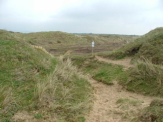
Cynffig/Kenfig is a Site of Special Scientific Interest which includes Kenfig Sands and its sand dunes near Kenfig in Bridgend County Borough, South Wales. The Kenfig National Nature Reserve is also situated at the site and contains the largest lake in Glamorgan, Kenfig Pool.
Kenfig Hill is a village in Bridgend County Borough, South Wales. It is bordered by Pyle to the south-west, Cefn Cribwr to the north-east, North Cornelly to the south and Moel Ton-Mawr mountain to the north.
The South Wales Coast and Severn Estuary Coastal Path covers Region H of the larger Wales Coast Path, an 870-mile (1,400 km) long-distance walking route around the whole coast of Wales which opened on 5 May 2012. The South Wales Coast and Severn Estuary stretch is a 109-mile (176 km) in length running from Kenfig Dunes near Port Talbot, South Wales to Chepstow. With five local councils involved in its creation and maintenance, the route goes through a heritage coast, three national nature reserves and three heritage landscapes.
Kenfig is a village and former borough in Bridgend, Wales.
Sarah Murphy is a Welsh Labour and Co-operative politician, serving as Minister for Mental Health and Wellbeing since July 2024.