
Pujali is a city and a municipality of the South 24 Parganas district in the Indian state of West Bengal. It is a part of the area covered by Kolkata Metropolitan Development Authority (KMDA).

Indpur is a community development block that forms an administrative division in the Khatra subdivision of the Bankura district in the Indian state of West Bengal.

Bhatar is a community development block that forms an administrative division in Bardhaman Sadar North subdivision of Purba Bardhaman district in the Indian state of West Bengal.

Siliguri

Harishchandrapur I is a community development block that forms an administrative division in Chanchal subdivision of Malda district in the Indian state of West Bengal.
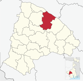
Indas is a community development block that forms an administrative division in the Bishnupur subdivision of the Bankura district in the Indian state of West Bengal.

Matigara is a community development block that forms an administrative division in the Siliguri subdivision of the Darjeeling district in the Indian state of West Bengal.

Namkhana is a community development block that forms an administrative division in the Kakdwip subdivision of the South 24 Parganas district in the Indian state of West Bengal.

Patharpratima is a community development block that forms an administrative division in the Kakdwip subdivision of the South 24 Parganas district in the Indian state of West Bengal.

Joypur is a community development block that forms an administrative division in the Bishnupur subdivision of the Bankura district in the Indian state of West Bengal.

Hirbandh is a community development block that forms an administrative division in the Khatra subdivision of the Bankura district in the Indian state of West Bengal.

Mathurapur I is a community development block that forms an administrative division in the Diamond Harbour subdivision of the South 24 Parganas district in the Indian state of West Bengal.
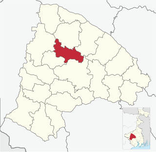
Bankura II is a community development block that forms an administrative division in the Bankura Sadar subdivision of the Bankura district in the Indian state of West Bengal.
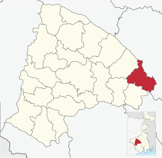
Barjora is a community development block that forms an administrative division in the Bankura Sadar subdivision of the Bankura district in the Indian state of West Bengal.

Bishnupur I is a community development block that forms an administrative division in the Alipore Sadar subdivision of the South 24 Parganas district in the Indian state of West Bengal.

Bishnupur II is a community development block that forms an administrative division in the Alipore Sadar subdivision of the South 24 Parganas district in the Indian state of West Bengal.

Jaynagar I is a community development block that forms an administrative division in the Baruipur subdivision of the South 24 Parganas district in the Indian state of West Bengal.

Kultali is a community development block that forms an administrative division in the Baruipur subdivision of the South 24 Parganas district in the Indian state of West Bengal.

Falta is a community development block that forms an administrative division in the Diamond Harbour subdivision of the South 24 Parganas district in the Indian state of West Bengal.

Kakdwip is a community development block that forms an administrative division in the Kakdwip subdivision of the South 24 Parganas district in the Indian state of West Bengal.
