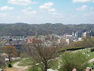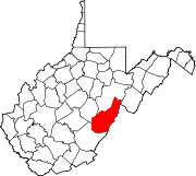
Charleston is the most populous city in, and the capital of, the U.S. state of West Virginia. Located at the confluence of the Elk and Kanawha rivers, the population during the 2017 Census Estimate was 47,929. The Charleston metropolitan area as a whole had 214,406 residents. Charleston is the center of government, commerce, and industry for Kanawha County, of which it is the county seat.

The Shenandoah Valley is a geographic valley and cultural region of western Virginia and the Eastern Panhandle of West Virginia in the United States. The valley is bounded to the east by the Blue Ridge Mountains, to the west by the eastern front of the Ridge-and-Valley Appalachians, to the north by the Potomac River and to the south by the James River. The cultural region covers a larger area that includes all of the valley plus the Virginia highlands to the west, and the Roanoke Valley to the south. It is physiographically located within the Ridge and Valley province and is a portion of the Great Appalachian Valley.

West Virginia University (WVU) is a public, land-grant, space-grant, research-intensive university in Morgantown, West Virginia, United States. Its other campuses include the West Virginia University Institute of Technology in Beckley and Potomac State College of West Virginia University in Keyser; and a second clinical campus for the University's medical and dental schools at Charleston Area Medical Center in Charleston. WVU Extension Service provides outreach with offices in all of West Virginia's 55 counties. Since 2001, WVU has been governed by the West Virginia University Board of Governors.

The City of Greater Bendigo is a local government area in Victoria, Australia, located in the central part of the state. It covers an area of 3,048 square kilometres (1,177 sq mi) and, at the 2016 Census, had a population of 110,477. It includes the city of Bendigo and the towns of Axedale, Elmore, Heathcote, Marong, Raywood and Strathfieldsaye. It was formed in 1994 from the amalgamation of the former City of Bendigo with the Borough of Eaglehawk, Shire of Strathfieldsaye, Shire of Huntly, Rural City of Marong and parts of the Shire of McIvor.

Dingee railway station is located on the Yungera line, in Victoria, Australia, and serves the northern Victorian town of Dingee.

This is a list of properties and historic districts in West Virginia that are listed on the National Register of Historic Places. There are listings in every one of West Virginia's 55 counties.

The Claret ash or Raywood ash is a cultivar of ash tree, a seedling variant of the Caucasian ash. The original seedling was discovered near a group of assorted ash trees in Sewell's nursery in the Mount Lofty Ranges in South Australia about 1910, and later grown at the nearby property Raywood. The tree was introduced to Britain in 1928 and to North America in 1956, although it did not become widely available there until 1979.

Fraxinus angustifolia, the narrow-leafed ash, is a species of Fraxinus native to central and southern Europe, northwest Africa, and southwest Asia.
Raywood railway station is located on the Yungera line serving the Victoria town of Raywood. It was closed to passenger traffic on 4 October 1981 as part of the New Deal timetable for country passengers.

The Huntington–Ashland metropolitan area is the largest metropolitan statistical area in West Virginia and includes seven counties across three states: West Virginia, Kentucky, and Ohio. New definitions from February 28, 2013 placed the population at 361,580. The MSA is nestled along the banks of the Ohio River within the Appalachian Plateau region. The area is referred to locally as the "Tri-State area". In addition, the three largest cities are referred to as the River Cities.
Keith Raywood, also credited as Keith Ian Raywood, is an American production designer.

Bendigo East is an electoral district of the Legislative Assembly in the Australian state of Victoria. It covers an area of 2,711 square kilometres (1,047 sq mi) covering the part of the city of Bendigo east of the Yungera railway line and surrounding rural areas to the north, east and south. It includes the Bendigo suburbs of East Bendigo, Epsom, Flora Hill, Kennington, Spring Gully, Strathfieldsaye, Strathdale, Quarry Hill, and White Hills, and the surrounding towns of Axedale, Bridgewater, Huntly, Mandurang, Marong and Raywood. It also includes parts of the localities of Eaglehawk, Elmore, Golden Square and Ravenswood, and the Bendigo campus of La Trobe University. It lies within the Northern Victoria Region of the upper house, the Legislative Council.
Raywood is an unincorporated community in Liberty County, Texas, United States.

The ADG Excellence in Production Design Awards are awards presented annually by the Art Directors Guild (ADG) to recognize excellence in production design and art direction in the film and television industries. Honorees are presented with an award made by New York firm, Society Awards.

Raywood is a town in northern Victoria, Australia. The town is in the City of Greater Bendigo, 185 kilometres (115 mi) north of the state capital, Melbourne. At the 2016 census, Raywood had a population of 318.
The 16th Art Directors Guild Awards, which were given on February 4, 2012, honored the best production designers of 2011.


