Red Banks, Brown County, Wisconsin

Last updated
Red Banks, Wisconsin
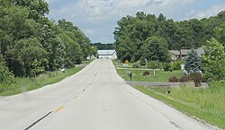
Red Banks Wisconsin Looking East.jpg
Looking east in Red Banks
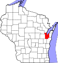
USA Wisconsin location map.svg
Red pog.svg
Red
Banks
Usa edcp location map.svg
Red pog.svg
Red
Banks
Coordinates: 44°36′40″N87°51′47″W / 44.61111°N 87.86306°W / 44.61111; -87.86306
Country Flag of the United States.svg  United States
State Flag of Wisconsin.svg  Wisconsin
County Brown
Town Scott
Elevation
190 m (630 ft)
Time zone UTC-6 (Central (CST))
  Summer (DST) UTC-5 (CDT)
Area code 920
GNIS feature ID1572129 [1]
Looking south in Red Banks Red Banks Wisconsin Looking south.jpg
Looking south in Red Banks

Red Banks is an unincorporated community located in the town of Scott, Brown County, Wisconsin, United States. [1]

History

Nicolet plaque near Red Bank Jean Nicolet commerative plaque at Red Banks WI from 1909.jpg
Nicolet plaque near Red Bank

In 1634, Jean Nicolet landed at Red Banks becoming the first European to explore the present state of Wisconsin. [2]

Notes

  1. 1 2 "Red Banks, Wisconsin". Geographic Names Information System . United States Geological Survey, United States Department of the Interior.
  2. Jean Nicolet at Red Banks, Wisconsin


Related Research Articles

<span class="mw-page-title-main">Vilas County, Wisconsin</span> County in Wisconsin, United States

Vilas County is a county in the state of Wisconsin, United States. As of the 2020 census, the population was 23,047. Its county seat is Eagle River. The county partly overlaps the reservation of the Lac du Flambeau Band of Lake Superior Chippewa.

<span class="mw-page-title-main">De Pere, Wisconsin</span> City in Wisconsin, United States

De Pere is a city in Brown County, Wisconsin, United States. The population was 25,410 at the 2020 census. De Pere is part of the Green Bay Metropolitan Statistical Area.

<span class="mw-page-title-main">Scott, Brown County, Wisconsin</span> Town in Wisconsin, United States

Scott is a town in Brown County in the U.S. state of Wisconsin. As of the 2020 census, the population was 3,636.

<span class="mw-page-title-main">Rhinelander, Wisconsin</span> City in Wisconsin, United States

Rhinelander is a city in and the county seat of Oneida County, Wisconsin, United States. The population was 8,285 at the 2020 census.

<span class="mw-page-title-main">Green Bay, Wisconsin</span> City in Wisconsin, United States

Green Bay is a city in the U.S. state of Wisconsin. The county seat of Brown County, it is at the head of Green Bay, a sub-basin of Lake Michigan, at the mouth of the Fox River. As of the 2020 Census, Green Bay had a population of 107,395, making it the third-largest in the state of Wisconsin, after Milwaukee and Madison, and the third-largest city on Lake Michigan, after Chicago and Milwaukee.

<span class="mw-page-title-main">Chequamegon–Nicolet National Forest</span> Nature preserve in northern Wisconsin, U.S.

The Chequamegon–Nicolet National Forest is a 1,530,647-acre (6,194.31 km2) U.S. National Forest in northern Wisconsin in the United States. Due to logging in the early part of the 20th century, very little old growth forest remains. Some of the trees there were planted by the Civilian Conservation Corps in the 1930s. The national forest land trees and vegetation are part of the North Woods Ecoregion that prevails throughout the upper Great Lakes region.

<span class="mw-page-title-main">Jean Nicolet</span>

Jean Nicolet (Nicollet), Sieur de Belleborne was a French coureur des bois noted for exploring Lake Michigan, Mackinac Island, Green Bay, and being the first European to set foot in what is now the U.S. state of Wisconsin.

<span class="mw-page-title-main">Menominee</span> Federally-recognized indigenous people of the United States

The Menominee are a federally recognized tribe of Native Americans officially known as the Menominee Indian Tribe of Wisconsin. Their land base is the Menominee Indian Reservation in Wisconsin. Their historic territory originally included an estimated 10 million acres (40,000 km2) in present-day Wisconsin and the Upper Peninsula of Michigan. The tribe currently has about 8,700 members.

<span class="mw-page-title-main">Northern Highland</span> Geographical region of Wisconsin

The Northern Highland is a geographical region in the north central United States covering much of the northern territory of the state of Wisconsin.

Nicollet or Nicolet may refer to:

<span class="mw-page-title-main">Wisconsin Highway 55</span>

State Trunk Highway 55 is a state highway in Wisconsin, United States. It travels south-to-north in the northeastern part of Wisconsin from an intersection with U.S. Route 151 (US 151) approximately 1.5 miles (2.4 km) north of Brothertown, near the eastern shore of Lake Winnebago in Calumet County, to the Michigan state line at the Brule River approximately one mile (1.6 km) northeast of Nelma in Forest County, where it connects to M-73.

<span class="mw-page-title-main">Nicolet High School</span> Public school in Glendale, Wisconsin, United States

Nicolet High School is a public secondary school located in Glendale, Wisconsin. It is the only school in the Nicolet Unified School District, which serves Glendale, Fox Point, Bayside, and River Hills. Primary schooling is administered by three feeder districts. The Nicolet Unified School district is one of the few school districts in Wisconsin to be made up of only one school. Its main feeder schools are Milwaukee Jewish Day School, Glen Hills Middle School, Maple Dale Middle School, and Bayside Middle School.

<span class="mw-page-title-main">Nicolet, Quebec</span> City in Quebec, Canada

Nicolet is the county seat of Nicolet-Yamaska Regional County Municipality, Quebec, Canada. The population as of the Canada 2016 Census was 8,169. It is the seat of the Roman Catholic Diocese of Nicolet.

WBDK is a radio station broadcasting an adult contemporary format. Licensed to Algoma, Wisconsin, United States, the station serves Brown, Door and Kewaunee counties. The station is currently owned by Bryan Mazur, through licensee Mazur, LLC.

<span class="mw-page-title-main">Blackjack Springs Wilderness</span>

The Blackjack Springs Wilderness is a 5,800-acre (23 km2) wilderness area northeast of Eagle River, Wisconsin. It is located within the Nicolet unit of the Chequamegon-Nicolet National Forest and is administered by the US Forest Service. The area protects four large, crystal-clear springs at the headwaters of Blackjack Creek, part of the Eagle River and Wisconsin River drainage. The area was added to the National Wilderness Preservation System by Congress in 1978 as part of the Wisconsin Wilderness Act following an effort spearheaded by Sen. William Proxmire and Rep. Robert John Cornell.

<span class="mw-page-title-main">Headwaters Wilderness</span> Wilderness area in Wisconsin, U.S.

The Headwaters Wilderness is a 22,033-acre (89 km2) wilderness area located within the Nicolet unit of the Chequamegon–Nicolet National Forest in northeastern Wisconsin. It is the largest federally designated wilderness area on Wisconsin's mainland.

<span class="mw-page-title-main">Nicolet Bankshares</span>

Nicolet Bankshares is a U.S. regional bank holding company based in Green Bay, Wisconsin. They are the parent company of Nicolet National Bank, the second largest Wisconsin-based bank.

The Rainbow Lake Wilderness is a 7,135-acre (29 km2) wilderness area located within the Chequamegon unit of the Chequamegon-Nicolet National Forest. The land is in northern Wisconsin and entirely in Bayfield County. The wilderness area is operated by the United States Forest Service.

The Whisker Lake Wilderness is a 7,270-acre (2,940 ha) tract of protected land in Florence County, Wisconsin, managed by the United States Forest Service. The wilderness is within the boundaries of the Chequamegon–Nicolet National Forest, and is on the border of Michigan and Wisconsin.