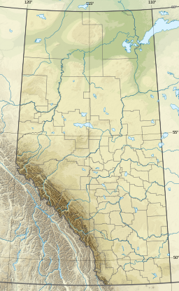
Alberta is one of the thirteen provinces and territories of Canada. It is a part of Western Canada and is one of the three prairie provinces. Alberta is bordered by British Columbia to the west, Saskatchewan to the east, the Northwest Territories to the north, and the U.S. state of Montana to the south. It is one of the only two landlocked provinces in Canada, with Saskatchewan being the other. The eastern part of the province is occupied by the Great Plains, while the western part borders the Rocky Mountains. The province has a predominantly continental climate but experiences quick temperature changes due to air aridity. Seasonal temperature swings are less pronounced in western Alberta due to occasional Chinook winds.
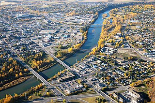
Red Deer is a city in Alberta, Canada, located midway on the Calgary–Edmonton Corridor. Red Deer serves central Alberta, and its key industries include health care, retail trade, construction, oil and gas, hospitality, manufacturing and education. It is surrounded by Red Deer County and borders on Lacombe County. The city is in aspen parkland, a region of rolling hills, alongside the Red Deer River.

Sylvan Lake is a town in central Alberta, Canada. It is located approximately 25 kilometres (16 mi) west of the City of Red Deer along Highway 11 or Highway 11A. It is on the southeast edge of Sylvan Lake, a 15-kilometre-long (9.3 mi) freshwater lake that straddles the boundary between Red Deer County and Lacombe County.
Shasta Lake, also popularly known as Lake Shasta, is a reservoir in Shasta County, California, United States. It began to store water in 1944 due to the impounding of the Sacramento River by Shasta Dam, the ninth tallest dam in the United States.
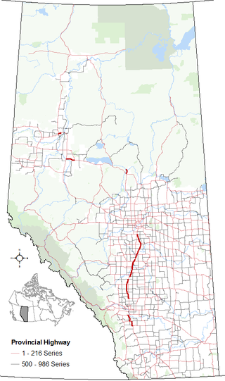
Alberta Provincial Highway No. 2, commonly referred to as Highway 2 or the Queen Elizabeth II Highway, is a major highway in Alberta that stretches from the Canada–United States border through Calgary and Edmonton to Grande Prairie. Running primarily north to south for approximately 1,273 kilometres (791 mi), it is the longest and busiest highway in the province carrying more than 170,000 vehicles per day near Downtown Calgary. The Fort Macleod—Edmonton section forms a portion of the CANAMEX Corridor that links Alaska to Mexico. More than half of Alberta's 4 million residents live in the Calgary–Edmonton Corridor created by Highway 2.
Alberta Provincial Highway No. 2A is the designation of six alternate routes off Highway 2 in Alberta, Canada. In general, these are original sections of Highway 2, such as the southern portion of Macleod Trail in Calgary. They passed through communities before limited-access freeways were built to shorten driving distance, accommodate heavier volumes and to bypass city traffic. Portions of the alignment of Highway 2A follow the route of the former Calgary and Edmonton Trail.

The Red Deer River is a river in Alberta and a small portion of Saskatchewan, Canada. It is a major tributary of the South Saskatchewan River and is part of the larger Saskatchewan / Nelson system that empties into Hudson Bay.

William A. Switzer Provincial Park is a provincial park in Alberta, Canada.
Buffalo Lake is a large lake in central Alberta. It is located in at the limit between Camrose County, the County of Stettler No. 6 and Lacombe County, approximately 40 km (25 mi) east of Red Deer.

Alberta Provincial Highway No. 11, commonly referred to as Highway 11 and officially named the David Thompson Highway, is a provincial highway in central Alberta, Canada. It runs for 318 km (198 mi) from Highway 93 at Saskatchewan River Crossing near Mount Sarbach in Banff National Park east to Highway 12 near Nevis. It passes by Nordegg and through Rocky Mountain House, Sylvan Lake and Red Deer along its course. The highway is named after David Thompson, a British-Canadian fur trader, surveyor, and map-maker who explored the area between Rocky Mountain House and Kootenae House through Howse Pass.
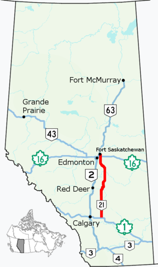
Alberta Provincial Highway No. 21, commonly referred to as Highway 21, is a north–south highway in Alberta, Canada that parallels Highway 2 between Calgary and Edmonton. It is approximately 328 kilometres (204 mi) in length. It begins at the Trans-Canada Highway (Highway 1) east of Strathmore, and ends at Fort Saskatchewan where it is succeeded by Highway 15. The northernmost 25 kilometres (16 mi) of the highway are twinned. Highway 21 runs roughly parallel to the main north–south CN rail line between Calgary and Edmonton between Three Hills and Looma.

Alberta Provincial Highway No. 11A is the designation of two routes that connect to Highway 11 in Alberta, Canada. The Rocky Mountain House section is referred to as 11A:02 by Alberta Transportation, while 11A:06 runs from Sylvan Lake to Red Deer.

Abraham Lake, also known as Lake Abraham, is an artificial lake and Alberta's largest reservoir. It is located in the "Kootenay Plains area of the Canadian Rockies' front range", on the North Saskatchewan River in western Alberta, Canada.

Southern Alberta is a region located in the Canadian province of Alberta. In 2016, the region's population was approximately 291,112. The primary cities are Lethbridge and Medicine Hat. The region is known mostly for agricultural production, but other sectors, such as alternative energy, film production and tourism, are emerging.
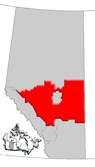
Central Alberta is a region located in the Canadian province of Alberta.

Gull Lake is a large lake in central Alberta, Canada. It is a popular recreational lake with its southern shores boasting large sandy beaches. Gull Lake is centrally located between Edmonton and Calgary and lies in two counties, Ponoka County and Lacombe County. The lake is accessed west of Ponoka on Highway 53 to get to the north side, or west of Lacombe on Highway 12 to reach the southern shores.
Jarvis Bay Provincial Park is a provincial park in Alberta, Canada, located 4 km (2.5 mi) north from Sylvan Lake and 35 km (22 mi) west from Red Deer, along Highway 20.
Gleniffer Lake also known as Gleniffer Reservoir or originally Lake Gleniffer is an artificial lake in central Alberta, Canada created in 1983 by the construction of the Dickson Dam which impounded the Red Deer River, a major tributary of the South Saskatchewan River which flows into the Saskatchewan River Basin.

Waconda Lake, also known as Glen Elder Reservoir, is a reservoir in Mitchell County and Osborne County, Kansas, United States. Built and managed by the U.S. Bureau of Reclamation for flood control and irrigation, it is also used for recreation. Glen Elder State Park is located on its north shore.
Gasoline Alley or Gasoline Alley West is a hamlet in the Canadian province of Alberta within Red Deer County. It is within the west portion of Gasoline Alley between Highway 2 and Highway 2A, 7 km (4.3 mi) south of downtown Red Deer.