Retrogressive thaw slumps

Last updated

Retrogressive thaw slumps (RTS), are a type of landslide that occur in the terrestrial Arctic's permafrost region of the circumpolar Northern Hemisphere when an ice-rich section thaws. RTSs develop quickly and can extend across several hectares modifying Arctic coastlines and permafrost terrain. [1] They are the most active and dynamic feature of thermokarst the collapse of the land surface as ground ice melts. [2] [3] They are thermokarst slope failures due to abrupt thawing of ice-rich permafrost or glaciated terrains. [4] [5] These horseshoe-shaped landslides contribute to the thawing of hectares of permafrost annually and are considered to be one of the most active and dynamic features of thermokarst the "processes and landforms that involve collapse of the land surface as a result of the melting of ground ice." [2] [3] They are found in permafrost or glaciated regions of the Northern Hemisphere the Tibetan Plateau, Siberia, from the Himalayas to northern Greenland, and in northern Canada's Northwest Territories (NWT), the Yukon Territories, Nunavut, and Nunavik and in the American state of Alaska. The largest RTS in the world is in Siberiathe Batagaika Crater, also called a "megaslump", is one-kilometre-long and 100 metres (330 ft) deep and it grows a 100 feet (30 m) annually. The land began to sink, and the Batagaika Crater began to form in the 1960s, following clear-cutting of a section of forested area.

Contents

Development and formation

Massive ice - retrogressive thaw slump - Herschel Island.png
"Several types of massive ground ice, including ice wedges and intrasedimental ice, observable within the cliff wall of a retrogressive thaw slump located on the southern coast of Herschel Island. This exposure has a headwall that measures in excess of 22 m high and is over 1.3 km long. This cliff exposure has been increasing in size on a yearly basis since it was first measured in 1950 from air photographs". Credit Dave Fox

As ice-rich permafrost and glacial terrain thaws, the melting ground ice causes the land surface to collapse through a series of processes resulting in the formation of an irregular land surface, called thermokarst, composed of hummocks and hollows. [6]

Retrogressive thaw slumps are the "most active geomorphic features" of thermokarst permafrost terrain". [7] Permafrost dates back hundreds of thousands of years; thermokarst and its featuressuch as retrogressive thaw slumpswhich are slope failures, have been initiated by terrain disturbance associated with clear-cutting forests, the construction of seismic lines and roads. [8]

The retrogressive thaw slump forms on massive ice or ice-rich permafrost, which is often covered in a layer of tundra vegetation under which a layer of peat may lie. [9] The RTS surface is convex and is located on the shoulder of the hillslope. [10]

The most thawing occurs on south- and west-facing slopes. [11] Ballantyne describes how, as scarp ice thaws it causes rapidly-evolving retrogressive slope failure or slumping. This landslide "exposes a fresh face" of ice-rich permafrost. [11] As thawing takes place, the ice-rich, steep, erosional headscarp retreats as it collapses. An active layer of basal sediment accumulates [9] flowing down a low-gradient slump floor. This flows downslope as it "collapses to the base of the exposure". [12] The floor or base of the retrogressive thaw slump is covered in then sediment—mudflows and braided hills. [9] As the headscarp progressively retreats, the slump floor extends. [9]

As the slopes thaw, the ice-rich permafrost is exposed and turns into a mud slurry. [12] Thermokarst processes may cause lakes to enlarge, peatlands to collapse and landslides or thaw slumps to develop." [12] [lower-alpha 1] "Retrogressive thaw slumps are among the most active geomorphological features in permafrost terrain." [13]

A 2009 study classified slumps as active, stable, and ancient. An active slump is one that has a clearly-defined headwall and bare areas; and a stable slump is one that has clearly-defined boundaries and is completely covered in vegetation. The headwall relief of an ancient slump is a subdued scar on the terrain that is covered in tundra vegetation. [14]

Geomorphic terminology

RTS morphology comprises a vertical headwall, an inclined headscarp, a floor filled with flow deposits, and a lobe that conveys thawed sediments downslope. [1] RTS morphology comprises the headwall, headscarp; a floor, and a lobe. [15] [1] The vertical headwall is steep and ice-rich; the downsloped headscarp is a "low-angled scar zone" composed of thawed slurry; the lobe is a tongue of debris in active slumps which is composed of saturated materials that flowed downslope. [15]

Retrogressive thaw slumps are slope failures due to abrupt thawing of ice-rich permafrost. [16] They have also been called ground-ice slumps, [17] thermocirques, [18] tundra mudflows, [19] retrogressive flow slides, [20] and bi-modal flows. [21] [13] These terms are no longer recommended by the National Snow and Ice Data Center (NSIDC). [21]

Yedoma are deposits of highly organic-rich [22] and ice-rich permafrost with ice content representing from 50 to 90% of its volume. [23] Much of the yedoma deposits have been frozen since 10,000 years ago, in the Pleistocene age. [22] As of 2011, the Yedoma domain covered 1,000,000 square kilometres (390,000 sq mi; 100,000,000 ha; 250,000,000 acres) of the northern permafrost zone, [24] mostly in Siberia, including northern Yakutia, and also in Alaska, and in the north of Canada, including the Yukon Territories. [25] [22] [lower-alpha 2]

A retrogressive thaw slump is a slow landslide caused by thawing yedoma. [26] [27] Because yedoma deposits are ice-rich, they are "especially prone to rapid-thaw processes" and "highly vulnerable to disturbances such as thermokarst and thermo-erosion processes". [28] [lower-alpha 3]

According to the definition of the Multi-Language Glossary of Permafrost and Related Ground-Ice Terms compiled by the International Permafrost Association (IPA)'s Terminology Working Group, "retrogressive thaw slumps consist of a steep headwall that retreats in a retrogressive fashion due to thawing, and a debris flow formed by the mixture of thawed sediment and meltwater that slides down the face of the headwall and flows away." [29]

Geographic distribution

Retrogressive thaw slumps are forms of the permafrost or glaciated regions and may be found in the Northern Hemisphere and the Tibetan Plateau, from the Himalayas to northern Greenland, in northern Canada and Alaska. [16] [30] [31] RTSs "are commonly found on the banks of northern rivers and lakes and along the arctic coast, especially where undercutting is active." [13]

Alaska

Arctic Coastal Plain, Teshekpuk Lake, Alaska by Brandt Meixell, USGS Permafrost (12116729705).jpg
Arctic Coastal Plain, Teshekpuk Lake, Alaska by Brandt Meixell, USGS

Canada

There are thousands of RTSs have been inventoried in the north of Canada. [32] [33] [34] [3] There were 212 RTS, varying in size "from 0.4 to 52 ha, with 10 slumps exceeding 20 ha", identified in the westward extent of the Laurentide Ice Sheet in northwestern Canada's Richardson Mountains and Peel Plateau regionof these "189 have been active since at least 1985". [10] These thaw slumps affect permafrost terrain in northwestern Canada, where thousands of them have been identified. [32] [33] [34] [3]

Multi-year studies have mapped and monitored of RTSs in the Mackenzie River Delta since 1950. Researchers found a "significantly higher growth rates" of RTSs from 1973 to 2004 than from 1950 to 1973, which suggested that a "regional driver of slump growth has subsumed site specific controls." [35]

China

Across the Tibetan Plateau also known as the Qinghai–Tibet Plateau (QTP)the 632 kilometres (393 mi)-long narrow engineering corridor on permafrostthe Qinghai-Tibet Engineering Corridor links Lhasa in inland China to the Golmud in the Tibet Autonomous Region. A 2022 inventory identified 875 widely distributed RTSs, [36] along the highly developed corridor with significant infrastructures, including the Qinghai–Tibet Railway and the Qinghai–Tibet Highway, "as well as power and communication towers". [37]

Russia

Batagaika Crater Batagaika crater NASA.jpg
Batagaika Crater

Two-thirds of Russia's territory consists of permafrost terrain—which represents that largest share in the world. [26] It is here in central Yakutia in the East Siberian taiga in Verkhoyansky District of the Sakha Republic that the largest retrogressive thaw slump, the Batagaika Crater is located. [26] Because of its massive size—it is one-kilometre-long and 100 metres (330 ft) deep and growing annually [38] —the Batagaika Crater, has been called a "megaslump"a large retrogressive thaw slump. [39] [38] The crater is a feature of a 'thermokarst depression'; in contrast to other thermokarst depressions in permafrost terrainincluding those found in the north of Canadathe Batagaika Crater is much deeper—from "two-to-three times deeper". [27]

In 2016, University of Sussex's scientist and professor, Julian Murton, led an expedition to undertake a pilot study of the Batagaika Crater—"one of 'most important' sites in the world for the study of permafrost". [27] The local residents living near the crater refer to it as a "gateway to Hell." [26] The Yakutian people, believe that the crater is the door way to under world, one of three worlds, which include the upper and middle worlds. [27]

The bottom layer of permafrost sediment has been estimated to be "at least six hundred and fifty thousand years old", based on luminescence dating of drill bores extracted by Murton and his team. [26] Murton said that this means that the permafrost "survived the previous interglacial period, which began some hundred and thirty thousand years ago...The oldest permafrost in Eurasia has been kicking around for over half a million years...Seeing as it survived intense global-warming events in the past, it must be pretty resilient." [26]

While permafrost is resilient, it is not invulnerable. Batagaika Crater began to form in the 1960s, following clear-cutting of a large forested area. It has been growing 100 feet (30 m) a year since then. [26] In 2008, there was major flooding in the area which accelerated to growth of the depression. [27]

In 2016 and 2017, a group of researchers studied retrogressive thaw slumps in Northeast Siberia: one at Kurungnakh Island in the Lena River Delta and the second in Duvanny Yar near the Kolyma River. In 2018, an international team of scientists, found a nematode in a Pleistocene squirrel burrow in the Duvanny Yar outcrop that was estimated to be about 32,000 years old. The scientists thawed the nematodes; it revived and began moving and eating, making it one of the oldest living multicellular animals on Earth. [40] [41]

Mongolia

There is a pingo retrogressive thaw slump in the Akkol Valley, one of three U-shaped valleys—including Taldura and Karaoyuk—that comprise the Altai Mountains South Chuyskiy Range in Mongolia. During the Holocene, these three valleys were occupied by ice at various times. [42] The Akkol valley permafrost-indicator features include rock glaciers, pingos. [42]

Climate change

As the climate warms, "terrain-altering thermokarst" retrogressive thaw slumps represent the "most rapid and dramatic changes" in permafrost regions. [43]

Permafrost in the Northern Hemisphere, which covered approximately 23,000,000 square kilometres (8,900,000 sq mi; 2.3×10⁹ ha; 5.7×10⁹ acres), representing 24% of the terrestrial area, as of 1997 [44] is vulnerable to climate warming. [28] Of the estimated 950 billion tonnes of carbon in permafrost, the yedoma domain stores just a little less than 50% of this carbon. [22]

RTS "represent a particularly dramatic landscape response that is expected to intensify in magnitude and frequency with future climate change." [4] They "contribute large volumes of materials downslope to lakes, drainage networks and coastal zones." [4]

Retrogressive thaw slumps development is one result of global warming as Arctic temperatures rise rapidly rise and permafrost thaws. [45] For this reason, permafrost environments are extremely vulnerable to climate change in the Arctic. [46] [lower-alpha 4] [lower-alpha 5] [lower-alpha 6]

Impact

RSTs thaw "hectares of permafrost annually." [3] [15] RTSs "typically retreat and expand at high rates". [16] RTSs damage "infrastructure, and releas[e] carbon preserved in frozen ground." [16]

Modification of streams and rivers

Thaw slumps "have been shown to modify the discharge of streams and rivers (Kokelj et al. 2013) and the geochemical composition and sediment loads of streams and lakes (Kokelj et al. 2009; Malone et al. 2013; Rudy et al. 2017; Tanski et al. 2017) [3]

"This has negatively affected aquatic ecosystems, including benthic macroinvertebrates communities (Chin et al. 2016). [3]

Potential consequences

Retrogressive thaw slumps threaten Canada's infrastructure and contributes to mercury contamination in the water. [47]

in the western Canadian Arctic, Inuvialuit residents of the hamlet of Sachs Harbour, Banks Island reported seeing an increase in the number of slumps, which had affected "travel for traditional hunting and fishing activities." [48] [5]

RTS monitoring

"Advances in remote sensing techniques, and their application in a broad suite of change detection studies, indicate recent increases in the rates and magnitude of thermokarst including retrogressive thaw slumping, lake expansion and the transformation of frozen peatlands to collapsed wetlands." [2]

In Canada, computerized alert systems are being installed to monitor humidity, temperature and other factors at RTSs that threaten infrastructure, such as the Alaska Highway. One of the first of these alert systems includes several in northern Quebec and one at the Takhini Slump. There are plans in place to set up systems along the Dempster Highway, in the Yukon Territories and the Northwest Territories. [49] The Takhini Slump, located 30 kilometres (30,000 m) north of Whitehorse is "thawing at faster rates than ever before", according to Fabrice Calmels and his research team who came to the area in 2019, when the Takhini Slump was 95 metres (312 ft) from the Alaska Highway; in 2021 it was 40 metres (130 ft) away. [49]

A 2022 Earth System Science Data report described the implementation of a number of sensors and integrated observation dataset used to monitor the RSSs "hydrological and thermal deformation" to mitigate infrastructure damage to the Qinghai-Tibet Engineering Corridor engineering projects. [37]

Mitigation

"[I]ncreased knowledge on the dynamics of thaw slump activity is required to better characterize their impact on the environment." [3] According to a 1990 study, woodchip insulation on ice-rich slopes were used to slow down slumping along the "pipeline route from Norman Wells, NWT, to Zama, Alberta." [15] [15]

Notes

  1. "The term thermokarst describes the processes and landforms that involve collapse of the land surface as a result of the melting of ground ice." (Kokelj and Jorgenson 2013)
  2. The National Snow and Ice Data Center (NSIDC) defines yedoma as a "type of Pleistocene-age (formed 1.8 million to 10,000 years before present) permafrost that contains a significant amount of organic material with ice content of 50– to 90 percent by volume. Thawing yedoma is a significant source of atmospheric methane."
  3. A geological slump is a common form of mass wasting, when a mass of material moves downward along a curved surface, usually neither fast of very far. The surface of the rupture is spoon-shaped and concave upward or outward. The slump creates a crescent-shaped scarp at the head and the block's upper surface is tilted backwards. When the slope is over-steeped, a slump commonly occurs. A slump can occur when the river edge becomes over-steeped or on a coastal cliff undercut by wave action."(Tarbuck and Lutgens 1999)
  4. "Radiocarbon dating showed that RTS were likely to have been active around 300 a BP and are undergoing a similar period of increased activity now." (Lantuit et al 2012)
  5. "The warmer and wetter northern climate during recent decades has led to increased thermokarst activity in permafrost terrain."(Armstrong et al 2018, (Kokelj and Jorgenson 2013)
  6. "Our observation that the most rapid intensification of slump activity occurred in the coldest environment (the Jesse Moraine on Banks Island) indicates that ice-cored landscapes in cold permafrost environments are highly vulnerable to climate change" (Segal, Lantz and Kokelj 2016)

Related Research Articles

<span class="mw-page-title-main">Tundra</span> Biome where plant growth is hindered by frigid temperatures

In physical geography, tundra is a type of biome where tree growth is hindered by frigid temperatures and short growing seasons. The term is a Russian word adapted from Sámi languages. There are three regions and associated types of tundra: Arctic tundra, alpine tundra, and Antarctic tundra.

<span class="mw-page-title-main">Permafrost</span> Soil frozen for a duration of at least two years

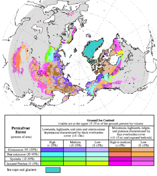
Permafrost is soil or underwater sediment which continuously remains below 0 °C (32 °F) for two years or more: the oldest permafrost had been continuously frozen for around 700,000 years. Whilst the shallowest permafrost has a vertical extent of below a meter (3 ft), the deepest is greater than 1,500 m (4,900 ft). Similarly, the area of individual permafrost zones may be limited to narrow mountain summits or extend across vast Arctic regions. The ground beneath glaciers and ice sheets is not usually defined as permafrost, so on land, permafrost is generally located beneath a so-called active layer of soil which freezes and thaws depending on the season.

<span class="mw-page-title-main">Utopia Planitia</span> Impact basin on Mars

Utopia Planitia is a large plain within Utopia, the largest recognized impact basin on Mars and in the Solar System with an estimated diameter of 3,300 km (2,100 mi). It is the Martian region where the Viking 2 lander touched down and began exploring on September 3, 1976, and the Zhurong rover touched down on May 14, 2021, as a part of the Tianwen-1 mission. It is located at the antipode of Argyre Planitia, centered at 46.7°N 117.5°E. It is also in the Casius quadrangle, Amenthes quadrangle, and the Cebrenia quadrangle of Mars.

<span class="mw-page-title-main">Tibetan Plateau</span> Plateau in Central, South and East Asia

The Tibetan Plateau, also known as Qinghai–Tibet Plateau and Qing–Zang Plateau, is a vast elevated plateau located at the intersection of Central, South, and East Asia covering most of the Tibet Autonomous Region, most of Qinghai, western half of Sichuan, Southern Gansu provinces in Western China, southern Xinjiang, Bhutan, the Indian regions of Ladakh and Lahaul and Spiti as well as Gilgit-Baltistan in Pakistan, northwestern Nepal, eastern Tajikistan and southern Kyrgyzstan. It stretches approximately 1,000 kilometres (620 mi) north to south and 2,500 kilometres (1,600 mi) east to west. It is the world's highest and largest plateau above sea level, with an area of 2,500,000 square kilometres (970,000 sq mi). With an average elevation exceeding 4,500 metres (14,800 ft) and being surrounded by imposing mountain ranges that harbor the world's two highest summits, Mount Everest and K2, the Tibetan Plateau is often referred to as "the Roof of the World".

<span class="mw-page-title-main">Talik</span>

A talik is a layer of year-round unfrozen ground that lies in permafrost areas. In regions of continuous permafrost, taliks often occur underneath shallow thermokarst lakes and rivers, where the deep water does not freeze in winter and thus the soil underneath does not freeze either. Sometimes closed, open, and through taliks are distinguished. These terms refer to whether the talik is surrounded by permafrost, open at the top, or open both at the top and above an unfrozen layer beneath the permafrost.

<span class="mw-page-title-main">Yamal Peninsula</span> Peninsula located in the Yamalo-Nenets Autonomous Okrug of Siberia, Russia

The Yamal Peninsula is located in the Yamalo-Nenets Autonomous Okrug of northwest Siberia, Russia. It extends roughly 700 km (435 mi) and is bordered principally by the Kara Sea, Baydaratskaya Bay on the west, and by the Gulf of Ob on the east. At the northern end of this peninsula lie the Malygina Strait and, beyond it, Bely Island. Across the river lies the Gyda Peninsula. In the language of its indigenous inhabitants, the Nenets, "Yamal" means "End of the Land".

<span class="mw-page-title-main">Thermokarst</span> Irregular land surface of marshy hollows and small hummocks formed when permafrost thaws

Thermokarst is a type of terrain characterised by very irregular surfaces of marshy hollows and small hummocks formed when ice-rich permafrost thaws. The land surface type occurs in Arctic areas, and on a smaller scale in mountainous areas such as the Himalayas and the Swiss Alps.

<span class="mw-page-title-main">Pingo</span> Mound of earth-covered ice

Pingos are intrapermafrost ice-cored hills, 3–70 m (10–230 ft) high and 30–1,000 m (98–3,281 ft) in diameter. They are typically conical in shape and grow and persist only in permafrost environments, such as the Arctic and subarctic. A pingo is a periglacial landform, which is defined as a non-glacial landform or process linked to colder climates. It is estimated that there are more than 11,000 pingos on Earth, with the Tuktoyaktuk peninsula area having the greatest concentration at a total of 1,350. There is currently remarkably limited data on pingos.

Aufeis is a sheet-like mass of layered ice that forms from successive flows of ground or river water during freezing temperatures. This form of ice is also called overflow, icings, or the Russian term, naled. The term "Aufeis" was first used in 1859 by Alexander von Middendorff following his observations of the phenomenon in northern Siberia.

Yedoma is an organic-rich Pleistocene-age permafrost with ice content of 50–90% by volume. Yedoma are abundant in the cold regions of eastern Siberia, such as northern Yakutia, as well as in Alaska and the Yukon.

<span class="mw-page-title-main">Drunken trees</span> Stand of trees displaced from their normal vertical alignment

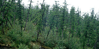
Drunken trees, tilted trees, or a drunken forest, is a stand of trees rotated from their normal vertical alignment.

<span class="mw-page-title-main">Climate change in the Arctic</span> Impacts of climate change on the Arctic

Due to climate change in the Arctic, this polar region is expected to become "profoundly different" by 2050. The speed of change is "among the highest in the world", with the rate of warming being 3-4 times faster than the global average. This warming has already resulted in the profound Arctic sea ice decline, the accelerating melting of the Greenland ice sheet and the thawing of the permafrost landscape. These ongoing transformations are expected to be irreversible for centuries or even millennia.

<span class="mw-page-title-main">Arctic methane emissions</span> Release of methane from seas and soils in permafrost regions of the Arctic

Arctic methane release is the release of methane from Arctic ocean waters as well as from soils in permafrost regions of the Arctic. While it is a long-term natural process, methane release is exacerbated by global warming. This results in a positive climate change feedback, as methane is a powerful greenhouse gas. The Arctic region is one of many natural sources of methane. Climate change could accelerate methane release in the Arctic, due to the release of methane from existing stores, and from methanogenesis in rotting biomass. When permafrost thaws as a consequence of warming, large amounts of organic material can become available for methanogenesis and may ultimately be released as methane.

<span class="mw-page-title-main">Katey Walter Anthony</span> American ecologist

Katey M. Walter Anthony is an Alaskan aquatic ecologist and biogeochemist researching carbon and nutrient cycling between terrestrial and aquatic systems, and the cryosphere and atmosphere.

<span class="mw-page-title-main">Sergey Zimov</span>

Sergey Aphanasievich Zimov is a Russian geophysicist who specialises in arctic and subarctic ecology. He is the Director of Northeast Scientific Station, a senior research fellow of the Pacific Institute for Geography, and one of the founders of Pleistocene Park. He is best known for his work in advocating the theory that human overhunting of large herbivores during the Pleistocene caused Siberia's grassland-steppe ecosystem to disappear and for raising awareness as to the important roles permafrost and thermokarst lakes play in the global carbon cycle.

Scalloped topography is common in the mid-latitudes of Mars, between 45° and 60° north and south. It is particularly prominent in the region of Utopia Planitia, in the northern hemisphere, and in the region of Peneus and Amphitrites Paterae in the southern hemisphere. Such topography consists of shallow, rimless depressions with scalloped edges, commonly referred to as "scalloped depressions" or simply "scallops". Scalloped depressions can be isolated or clustered and sometimes seem to coalesce. A typical scalloped depression displays a gentle equator-facing slope and a steeper pole-facing scarp. This topographic asymmetry is probably due to differences in insolation. Scalloped depressions are believed to form from the removal of subsurface material, possibly interstitial ice, by sublimation. This process may still be happening at present. This topography may be of great importance for future colonization of Mars because it may point to deposits of pure ice.

<span class="mw-page-title-main">Permafrost carbon cycle</span> Sub-cycle of the larger global carbon cycle

The permafrost carbon cycle or Arctic carbon cycle is a sub-cycle of the larger global carbon cycle. Permafrost is defined as subsurface material that remains below 0o C for at least two consecutive years. Because permafrost soils remain frozen for long periods of time, they store large amounts of carbon and other nutrients within their frozen framework during that time. Permafrost represents a large carbon reservoir, one which was often neglected in the initial research determining global terrestrial carbon reservoirs. Since the start of the 2000s, however, far more attention has been paid to the subject, with an enormous growth both in general attention and in the scientific research output.

<i>Silene stenophylla</i> Species of flowering plant

Silene stenophylla is a species of flowering plant in the family Caryophyllaceae. Commonly called narrow-leafed campion, it is a species in the genus Silene. It grows in the Arctic tundra of far eastern Siberia and the mountains of northern Japan. Frozen samples, estimated via radiocarbon dating to be around 32,000 years old, were discovered in the same area as current living specimens, and in 2012, a team of scientists successfully regenerated a plant from the samples.

<span class="mw-page-title-main">Batagaika crater</span> Thermokarst crater in Siberia, Russia

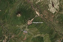
The Batagaika crater is a thermokarst depression in the Chersky Range area. The biggest permafrost crater in the world, it administratively belongs to the Sakha Republic, Russia, and is in its Verkhoyansky District.

<span class="mw-page-title-main">Espenberg volcanic field</span> Historical volcanic area in Alaska, United States

Espenberg is a volcanic field in Alaska that contains the largest maars on Earth. It was active during the Pleistocene until 17,500 years BP, when a large eruption formed the 8 by 6 kilometres wide Devil Mountain Maar and deposited tephra over 2,500 square kilometres (970 sq mi), burying vegetation and forming the largest maar on Earth. Other maars in the field are the North and South Killeak Maars and Whitefish Maar, and Devil Mountain is a shield volcano.

References

  1. 1 2 3 Ramage et al. 2017, p. 1619.
  2. 1 2 3 Kokelj & Jorgenson 2013.
  3. 1 2 3 4 5 6 7 8 Armstrong et al. 2018.
  4. 1 2 3 Turner, Pearce & Hughes 2021.
  5. 1 2 Lewkowicz 2019.
  6. Armstrong et al. 2018
    Environment and Natural Resources 2014
    Kokelj & Jorgenson 2013
    Kokelj & Jorgenson 2013
  7. Armstrong et al. 2018
    Burn & Lewkowicz 1990
    Kokelj & Jorgenson 2013
  8. Bliss & Wein 1971
    Lambert 1972
    Burn & Friele 1989 , p. 31
    Yaffa 2022
  9. 1 2 3 4 Ballantyne 2018, p. 133,134.
  10. 1 2 Lacelle et al. 2015, p. 40.
  11. 1 2 Ballantyne 2018, p. 135.
  12. 1 2 3 Environment and Natural Resources 2014.
  13. 1 2 3 Burn & Friele 1989, p. 31.
  14. Kokelj et al. 2009, p. 177.
  15. 1 2 3 4 5 Burn & Lewkowicz 1990.
  16. 1 2 3 4 Xia et al. 2022, p. 1.
  17. MacKay 1966.
  18. Czudek & Demek 1970.
  19. Lamothe & St. Onge 1961.
  20. Hughes 1972.
  21. 1 2 McRoberts & Morgenstern 1973.
  22. 1 2 3 4 Mascarelli 2009.
  23. Walter et al. 2006.
  24. Grosse et al. 2011.
  25. Strauss et al. 2017.
  26. 1 2 3 4 5 6 7 Yaffa 2022.
  27. 1 2 3 4 5 The Siberian Times 2016.
  28. 1 2 Strauss et al. 2017, p. 75.
  29. Everdingen 2002.
  30. Wang et al. 2018.
  31. Zhang et al. 1999.
  32. 1 2 Lantuit et al. 2012.
  33. 1 2 Lacelle et al. 2015.
  34. 1 2 Segal, Lantz & Kokelj 2016.
  35. Lantz & Kokelj 2008.
  36. Xia et al. 2022, p. 1,9.
  37. 1 2 Luo et al. 2021.
  38. 1 2 Struzik 2020.
  39. Colucci 2021.
  40. Shatilovich et al. 2018.
  41. The Siberian Times 2018.
  42. 1 2 Fukui et al. 2007.
  43. Bernhard, Zwieback & Hajnsek 2021.
  44. Brown, Sidlauskas & Delinski 1997.
  45. Schuur & Abbott 2011.
  46. Cheng & Wu 2007.
  47. McKinley 2021.
  48. Riedlinger & Berkes 2001.
  49. 1 2 Desmarais 2021.

Sources