Rhinebeck (town), New York

Last updated

Rhinebeck, New York
Rhinebeck, NY, town hall.jpg
Rhinebeck Town Hall
Town Seal of Rhinebeck, New York.jpg
Dutchess County New York incorporated areas Rhinebeck highlighted.svg
Location of Rhinebeck, New York
Coordinates: 41°55′39″N73°54′32″W / 41.92750°N 73.90889°W / 41.92750; -73.90889
Country United States
State New York
County Dutchess
Government
  Type Town Council
   Town Supervisor Elizabeth Spinzia (D)
   Town Council
Members' List
Area
[1]
  Total39.8 sq mi (103.1 km2)
  Land35.7 sq mi (92.5 km2)
  Water4.1 sq mi (10.6 km2)
Elevation
200 ft (61 m)
Population
 (2020) [2]
  Total7,596
  Density213/sq mi (82.1/km2)
Time zone UTC-5 (Eastern (EST))
  Summer (DST) UTC-4 (EDT)
ZIP code
12572
Area code 845
FIPS code 36-61357
GNIS feature ID0962436
Website www.rhinebeckny.gov

Rhinebeck is a town in Dutchess County, New York, United States. The population was 7,596 at the 2020 census. [2] It is part of the Poughkeepsie-Newburgh-Middletown metropolitan area as well as the larger New York metropolitan area.

Contents

The town of Rhinebeck is in the northwestern part of Dutchess County in the Hudson Valley. "Rhinebeck" also refers to the village of Rhinebeck, located within the town. Rhinebeck residents living within the village are citizens of the town as well, but town residents living outside of the village line are not citizens of the village.

U.S. Route 9 passes through the town. It also includes the hamlet of Rhinecliff, which has an Amtrak station with service to Burlington, Montreal, Toronto, Chicago, Cleveland, Buffalo, Albany, and New York City.

Rhinebeck is home of the Dutchess County Fair.

Geography

According to the United States Census Bureau, the town has a total area of 39.8 square miles (103.1 km2), of which 35.7 square miles (92.5 km2) is land and 4.1 square miles (10.6 km2), or 10.24%, is water. [1]

The western town line, marked by the Hudson River, is the border of Ulster County. Neighboring Dutchess County towns are Red Hook to the north, Milan and Clinton to the east, and Hyde Park to the south.

Demographics

Historical population
CensusPop.Note
2000 7,762
2010 7,548−2.8%
2020 7,5960.6%
[3] [2]

As of the census [4] of 2000, there were 7,762 people, 3,001 households, and 1,797 families residing in the town. The population density was 214.1 inhabitants per square mile (82.7/km2). There were 3,255 housing units at an average density of 89.8 per square mile (34.7/km2). The racial makeup of the town was 92.5% white, 3.61% African American, .09% Native American, 1.37% Asian, 1.17% from other races, and 1.26% from two or more races. Hispanic or Latino of any race were 3.94% of the population.

There were 3,001 households, out of which 25.9% had children under the age of 18 living with them, 50.2% were married couples living together, 7.1% had a female householder with no husband present, and 40.1% were non-families. 34% of all households were made up of individuals, and 15.2% had someone living alone who was 65 years of age or older. The average household size was 2.22 and the average family size was 2.87.

In the town, the population was spread out, with 20.3% under the age of 18, 5.8% from 18 to 24, 25.4% from 25 to 44, 25.7% from 45 to 64, and 22.8% who were 65 years of age or older. The median age was 44 years. For every 100 females, there were 91.5 males. For every 100 females age 18 and over, there were 84.1 males.

The median income for a household in the town was $52,679, and the median income for a family was $67,837. Males had a median income of $49,028 versus $31,995 for females. The per capita income for the town was $29,069. About 3.1% of families and 9.7% of the population were below the poverty line, including 6.9% of those under age 18 and 5.6% of those age 65 or over.

The Methodist Church and Academy at Rhinebeck, N.Y. (circa 1856-1860) by John Warner Barber BarberJohnWarnerMethodistRhinebeck.jpg
The Methodist Church and Academy at Rhinebeck, N.Y. (circa 1856-1860) by John Warner Barber

In 1941, in Rhinebeck, a set of four historic panoramas of London, dating from about 1810, were found lining a barrel of pistols. [5] The Rhinebeck panorama was acquired by the Museum of London in 1998.

Notable people

Communities and locations in the town of Rhinebeck

Related Research Articles

<span class="mw-page-title-main">Dutchess County, New York</span> County in New York, United States

Dutchess County is a county in the U.S. state of New York. As of the 2020 census, the population was 295,911. The county seat is the city of Poughkeepsie. The county was created in 1683, one of New York's first twelve counties, and later organized in 1713. It is located in the Mid-Hudson Region of the Hudson Valley, north of New York City.

<span class="mw-page-title-main">Ancram, New York</span> Town in New York, United States

Ancram is a town in Columbia County, New York, United States. The population was 1,440 at the 2020 census, down from 1,573 at the 2010 census. The town was named after Ancram, Scotland.

<span class="mw-page-title-main">Beekman, New York</span> Town in New York, United States

Beekman is a town in Dutchess County, New York, United States. It is part of the Poughkeepsie–Newburgh–Middletown, NY Metropolitan Statistical Area as well as the larger New York–Newark–Bridgeport, NY-NJ-CT-PA Combined Statistical Area. The population was 14,172 at the 2020 census. The town was named after Henry Beekman, a 17th-century land owner.

<span class="mw-page-title-main">Brinckerhoff, New York</span> Census-designated place in New York, United States

Brinckerhoff is a hamlet and census-designated place (CDP) in Dutchess County, New York, United States. The population was 2,900 at the 2010 census. It is part of the Poughkeepsie–Newburgh–Middletown, NY Metropolitan Statistical Area as well as the larger New York–Newark–Bridgeport, NY-NJ-CT-PA Combined Statistical Area.

<span class="mw-page-title-main">Clinton, Dutchess County, New York</span> Town in New York, United States

Clinton is a town in Dutchess County, New York, United States. The population was 4,037 in the 2020 census, down from 4,312 in the 2010 census.

<span class="mw-page-title-main">East Fishkill, New York</span> Town in New York, United States

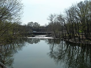
East Fishkill is a town on the southern border of Dutchess County, New York, United States. The population was 29,707 at the 2020 census. Until its creation in 1849, the town was the eastern portion of the town of Fishkill.

<span class="mw-page-title-main">Milan, New York</span> Town in New York, United States

Milan is a town in Dutchess County, New York, United States. The town is in the northern part of the county and is very rural. As of the 2020 census it had a population of 2,245, slightly down from 2,370 in 2010. Milan is located approximately 90 miles (140 km) north of New York City, 60 miles (97 km) south of Albany, and 150 miles (240 km) west of Boston. It is bordered by Rhinebeck and Red Hook to the west, Pine Plains to the east, Stanford to the southeast, Clinton to the south, and Gallatin to the north by Columbia County. The only major route in the town is the historic Taconic State Parkway, though NY 199 serves as the main local thoroughfare.

<span class="mw-page-title-main">North East, New York</span> Town in New York, United States

North East is a town in Dutchess County, New York, United States. The population was 3,031 at the 2020 census. The town is in the northeastern corner of the county. U.S. Route 44 crosses the town.

<span class="mw-page-title-main">Red Oaks Mill, New York</span> Census-designated place in New York, United States

Red Oaks Mill is a hamlet and census-designated place (CDP) in Dutchess County, in the U.S. state of New York. It lies within the limits of the towns of Poughkeepsie and LaGrange. The population was 3,613 at the 2010 census.

<span class="mw-page-title-main">Stanford, New York</span> Town in New York, United States

Stanford is a town in the north-central part of Dutchess County, New York, United States. The population was 3,628 at the 2020 census, down from 3,823 at the 2010 census.

<span class="mw-page-title-main">Union Vale, New York</span> Town in New York, United States

Union Vale is a town in Dutchess County, New York, United States. The population was 4,558 at the 2020 census.

<span class="mw-page-title-main">Washington, New York</span> Town in Dutchess County, New York, US

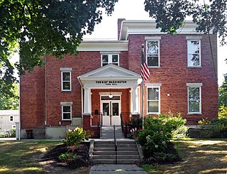
Washington is a town in Dutchess County, New York, United States. The population was 4,522 at the 2020 census. The town is named after George Washington, who passed through the town during the Revolution.

<span class="mw-page-title-main">Philipstown, New York</span> Town in New York, United States

Philipstown is a town located in the western part of Putnam County, New York, United States. The population was 9,831 at the 2020 census.

<span class="mw-page-title-main">Cortlandt, New York</span> Town in New York, United States

Cortlandt is a town in Westchester County, New York, United States, located at the northwestern edge of the county, at the eastern terminus of the Bear Mountain Bridge. The town includes the villages of Buchanan and Croton-on-Hudson.

<span class="mw-page-title-main">Pine Plains (town), New York</span> Town in New York, United States

Pine Plains is a town in Dutchess County, New York, United States. The population was 2,218 at the 2020 census.

<span class="mw-page-title-main">Poughkeepsie (town), New York</span> Town in New York, United States

Poughkeepsie, officially the Town of Poughkeepsie, is a town in Dutchess County, New York, United States. As of the 2020 United States Census, the population was 45,471. The name is derived from the native term Uppuqui meaning "lodge-covered", plus ipis meaning "little water", plus ing meaning "place", all of which translates to "the reed-covered lodge by the little water place", or Uppuqui-ipis-ing. This later evolved into Apokeepsing, then into Poughkeepsing, and finally Poughkeepsie.

<span class="mw-page-title-main">Red Hook (village), New York</span> Village in New York, United States

Red Hook is a village in Dutchess County, New York, United States. The population was 1,975 at the 2020 census. It is part of the Poughkeepsie–Newburgh–Middletown, NY Metropolitan Statistical Area as well as the larger New York–Newark–Bridgeport, NY-NJ-CT-PA Combined Statistical Area. The name is derived from the Dutch "Roode Hoeck" – hoeck meaning peninsula, and roode meaning red – a reference to the vibrant reds in the area's fall foliage.

<span class="mw-page-title-main">Red Hook, New York</span> Town in New York, United States

Red Hook is a town in Dutchess County, New York, United States. The population was 9,953 at the time of the 2020 census, down from 11,319 in 2010. The name is supposedly derived from the red foliage on trees on a small strip of land on the Hudson River The town contains two villages, Red Hook and Tivoli. The town is in the northwest part of Dutchess County.

<span class="mw-page-title-main">Rhinebeck (village), New York</span> Village in New York, United States

Rhinebeck is a village in the town of Rhinebeck in Dutchess County, New York, United States. The population was 2,657 at the 2010 census. It is part of the Poughkeepsie–Newburgh–Middletown, NY Metropolitan Statistical Area as well as the larger New York–Newark–Connecticut.

<span class="mw-page-title-main">Rhinecliff, New York</span> Census-designated place in New York, United States

Rhinecliff is a hamlet and census-designated place (CDP) located along the Hudson River in the town of Rhinebeck in northern Dutchess County, New York, United States. As of the 2010 census, the population of Rhinecliff was 425.

References

  1. 1 2 "2020 U.S. Gazetteer Files". United States Census Bureau. Retrieved March 8, 2024.
  2. 1 2 3 "QuickFacts: Rhinebeck town, Dutchess County, New York". United States Census Bureau . Retrieved March 8, 2024.
  3. "Geographic Identifiers: 2010 Demographic Profile Data (G001): Rhinebeck town, Dutchess County, New York". U.S. Census Bureau, American Factfinder. Archived from the original on February 13, 2020. Retrieved November 16, 2015.
  4. "U.S. Census website". United States Census Bureau . Retrieved January 31, 2008.
  5. Weekend (Guardian Magazine), London, p.65, 24 Nov 2007
  6. Retrieved from The New York Times on July 9, 2023

41°55′39″N73°54′31″W / 41.92750°N 73.90861°W / 41.92750; -73.90861