Robinson, North Dakota

Last updated

Robinson, North Dakota
Robinson, North Dakota 6-13-2008.jpg
Street in Robinson
ND Kidder County Robinson.svg
Location of Robinson, North Dakota
Coordinates: 47°08′31″N99°46′53″W / 47.14194°N 99.78139°W / 47.14194; -99.78139
CountryUnited States
State North Dakota
County Kidder
Government
  TypeCity Council
  MayorDel Jasper
Area
[1]
  Total0.17 sq mi (0.45 km2)
  Land0.17 sq mi (0.45 km2)
  Water0.00 sq mi (0.00 km2)
Elevation
[2]
1,788 ft (545 m)
Population
 (2020)
  Total36
  Density209.30/sq mi (80.72/km2)
Time zone UTC-6 (CST)
  Summer (DST) UTC-5 (CDT)
ZIP code
58478
Area code 701
FIPS code 38-67180
GNIS feature ID1036240 [2]

Robinson is a city in Kidder County, North Dakota, United States. The population was 36 at the 2020 census. [3] Robinson was founded in 1911.

Contents

Geography

According to the United States Census Bureau, the city has a total area of 0.17 square miles (0.44 km2), all land. [4]

In 2016, Hanson's bar, located in Robinson, registered a trademark in the phrase "Geographical Center of North America", [5] despite Rugby, North Dakota having previously made that claim and establishing a monument to that effect based on a determination made by the United States Geological Survey in 1931. [6]

Demographics

Historical population
CensusPop.Note
1930 185
1940 160−13.5%
1950 1663.8%
1960 155−6.6%
1970 125−19.4%
1980 1293.2%
1990 87−32.6%
2000 71−18.4%
2010 37−47.9%
2020 36−2.7%
2021 (est.)31 [7] −13.9%
U.S. Decennial Census [8]
2020 Census [3]

2010 census

As of the census [9] of 2010, there were 37 people, 19 households, and 10 families residing in the city. The population density was 217.6 inhabitants per square mile (84.0/km2). There were 56 housing units at an average density of 329.4 per square mile (127.2/km2). The racial makeup of the city was 100.0% White.

There were 19 households, of which 26.3% had children under the age of 18 living with them, 36.8% were married couples living together, 15.8% had a female householder with no husband present, and 47.4% were non-families. 42.1% of all households were made up of individuals, and 21.1% had someone living alone who was 65 years of age or older. The average household size was 1.95 and the average family size was 2.70.

The median age in the city was 49.3 years. 18.9% of residents were under the age of 18; 5.4% were between the ages of 18 and 24; 16.2% were from 25 to 44; 32.4% were from 45 to 64; and 27% were 65 years of age or older. The gender makeup of the city was 54.1% male and 45.9% female.

2000 census

As of the census of 2000, there were 71 people, 40 households, and 21 families residing in the city. The population density was 432.2 inhabitants per square mile (166.9/km2). There were 56 housing units at an average density of 340.9 per square mile (131.6/km2). The racial makeup of the city was 100.00% White.

There were 40 households, out of which 10.0% had children under the age of 18 living with them, 45.0% were married couples living together, 2.5% had a female householder with no husband present, and 47.5% were non-families. 47.5% of all households were made up of individuals, and 30.0% had someone living alone who was 65 years of age or older. The average household size was 1.78 and the average family size was 2.43.

In the city, the population was spread out, with 11.3% under the age of 18, 5.6% from 18 to 24, 14.1% from 25 to 44, 23.9% from 45 to 64, and 45.1% who were 65 years of age or older. The median age was 59 years. For every 100 females, there were 91.9 males. For every 100 females age 18 and over, there were 85.3 males.

The median income for a household in the city was $30,625, and the median income for a family was $33,333. Males had a median income of $25,625 versus $21,875 for females. The per capita income for the city was $15,712. There were 8.3% of families and 7.8% of the population living below the poverty line, including no under eighteens and 20.0% of those over 64.

See also

Related Research Articles

<span class="mw-page-title-main">Brinsmade, North Dakota</span> City in North Dakota, United States

For people with the surname, see Brinsmade (surname).

<span class="mw-page-title-main">Minnewaukan, North Dakota</span> City in North Dakota, United States

Minnewaukan is a city in Benson County, North Dakota, United States. It serves as the county seat and is fourth largest city in the county, after Fort Totten, Leeds, and Maddock. The population was 199 at the 2020 census. Minnewaukan was founded in 1884.

<span class="mw-page-title-main">Warwick, North Dakota</span> City in North Dakota, United States

Warwick is a city in Benson County, North Dakota, United States. The population was 55 at the 2020 census. Warwick was founded in 1907.

<span class="mw-page-title-main">Landa, North Dakota</span> City in North Dakota, United States

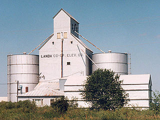
Landa is a city in Bottineau County, North Dakota, United States. The population was 41 at the 2020 census. Landa was founded in 1904.

<span class="mw-page-title-main">Alice, North Dakota</span> City in North Dakota, United States

Alice is a city in Cass County, North Dakota, United States. The population was 41 at the 2020 census.

<span class="mw-page-title-main">Argusville, North Dakota</span> City in North Dakota, United States

Argusville is a city in Cass County, North Dakota, United States. The population was 480 at the 2020 census. Increasing from 147 a decade earlier due to a huge housing boom from 2004 to 2008. Argusville was founded in 1881.

<span class="mw-page-title-main">Ayr, North Dakota</span> City in North Dakota, United States

Ayr is a city in Cass County, North Dakota, United States. The population was 11 at the 2020 census. Ayr was founded in 1883.

<span class="mw-page-title-main">Gardner, North Dakota</span> City in North Dakota, United States

Gardner is a city in Cass County, North Dakota, United States. The population was 129 at the 2020 census.

<span class="mw-page-title-main">Leonard, North Dakota</span> City in North Dakota, United States

Leonard is a city in Cass County, North Dakota, United States. The population was 248 at the 2020 census. Leonard was founded in 1881.

<span class="mw-page-title-main">North River, North Dakota</span> City in North Dakota, United States

North River is a city in Cass County, North Dakota, United States. The population was 55 at the 2020 census. North River was founded in 1973. It is a suburb/bedroom community directly adjacent to the city of Fargo.

<span class="mw-page-title-main">Wishek, North Dakota</span> City in North Dakota, United States

Wishek is a city in McIntosh County, North Dakota, United States. The population was 864 at the 2020 census.

<span class="mw-page-title-main">Dwight, North Dakota</span> City in North Dakota, United States

Dwight is a city in Richland County, North Dakota, United States. The population was 80 at the 2020 census. Dwight was founded in 1881. It is part of the Wahpeton, ND–MN Micropolitan Statistical Area.

<span class="mw-page-title-main">Woodworth, North Dakota</span> City in North Dakota, United States

Woodworth is a city in Stutsman County, North Dakota, United States. The population was 44 at the 2020 census.

<span class="mw-page-title-main">Ardoch, North Dakota</span> City in North Dakota, United States

Ardoch is a city in Walsh County, North Dakota, United States. The population was 31 at the 2020 census. Ardoch, named for the community of Ardoch, Ontario, was founded in 1881.

<span class="mw-page-title-main">Hoople, North Dakota</span> City in North Dakota, United States

Hoople is a city in Walsh County, North Dakota, United States. The population was 247 at the 2020 census. Hoople, named for early settler Alan Hoople, was founded in 1889. Hoople's nickname is "Tatertown."

<span class="mw-page-title-main">Park River, North Dakota</span> City in North Dakota, United States

Park River is a city in Walsh County, North Dakota, United States. The population was 1,424 at the 2020 census. Park River was founded in 1884.

<span class="mw-page-title-main">Groton, South Dakota</span> City in South Dakota, United States

Groton is a city in southeastern Brown County, South Dakota, United States. The population was 1,380 at the 2020 census.

<span class="mw-page-title-main">Whitewood, South Dakota</span> City in South Dakota, United States

Whitewood is a city in Lawrence County, South Dakota, United States. The population was 879 at the 2020 census.

<span class="mw-page-title-main">Carthage, South Dakota</span> City in South Dakota, United States

Carthage is a city in Miner County, South Dakota, United States. The population was 127 at the 2020 census.

<span class="mw-page-title-main">Hartford, South Dakota</span> City in South Dakota, United States

Hartford is a suburban American city in Minnehaha County, South Dakota, a few miles northwest of Sioux Falls. Its population was 3,354 at the 2020 census.

References

  1. "ArcGIS REST Services Directory". United States Census Bureau. Retrieved September 20, 2022.
  2. 1 2 U.S. Geological Survey Geographic Names Information System: Robinson, North Dakota
  3. 1 2 "Explore Census Data". United States Census Bureau . Retrieved April 25, 2022.
  4. "US Gazetteer files 2010". United States Census Bureau. Archived from the original on January 25, 2012. Retrieved June 14, 2012.
  5. GEOGRAPHICAL CENTER OF NORTH AMERICA, ser. no. 86/710,334 (filed July 30, 2015), reg. no. 5,033,374 (August 30, 2016). United States Patent and Trademark Office. Accessed January 4, 2017.
  6. Connors, Will (December 16, 2016). "North Dakota Bar Owner Pulls Off a Monumental Coup - WSJ". Wall Street Journal.
  7. "City and Town Population Totals: 2020-2021". United States Census Bureau. June 27, 2022. Retrieved June 27, 2022.
  8. United States Census Bureau. "Census of Population and Housing" . Retrieved October 30, 2013.
  9. "U.S. Census website". United States Census Bureau . Retrieved June 14, 2012.