Tappen, North Dakota

Last updated

Tappen, North Dakota
Tappen Oil Company - Tappen, North Dakota 6-10-2008.jpg
Tappen Oil Company - Tappen
ND Kidder County Tappen.svg
Location of Tappen, North Dakota
Coordinates: 46°52′33″N99°37′55″W / 46.87583°N 99.63194°W / 46.87583; -99.63194
CountryUnited States
State North Dakota
County Kidder
Founded1882
Area
[1]
  Total1.05 sq mi (2.72 km2)
  Land1.05 sq mi (2.72 km2)
  Water0.00 sq mi (0.00 km2)
Elevation
[2]
1,772 ft (540 m)
Population
 (2020) [3]
  Total217
  Estimate 
(2022) [4]
216
  Density206.86/sq mi (79.89/km2)
Time zone UTC-6 (Central (CST))
  Summer (DST) UTC-5 (CDT)
ZIP code
58487
Area code 701
FIPS code 38-77980
GNIS feature ID1036292 [2]

Tappen is a city in Kidder County, North Dakota, United States. The population was 217 at the 2020 census. [3]

Contents

History

Tappen was founded in 1882. The city was named for Sheppard Tappen, a local landowner. [5] A post office has been in operation at Tappen since 1882. [6]

Geography

According to the United States Census Bureau, the city has a total area of 1.05 square miles (2.72 km2), all land. [7]

Demographics

Historical population
CensusPop.Note
1920 182
1930 20814.3%
1940 32355.3%
1950 37917.3%
1960 326−14.0%
1970 294−9.8%
1980 271−7.8%
1990 239−11.8%
2000 210−12.1%
2010 197−6.2%
2020 21710.2%
2022 (est.)216 [4] −0.5%
U.S. Decennial Census [8]
2020 Census [3]

2010 census

As of the census of 2010, there were 197 people, 89 households, and 52 families residing in the city. The population density was 187.6 inhabitants per square mile (72.4/km2). There were 106 housing units at an average density of 101.0 per square mile (39.0/km2). The racial makeup of the city was 97.0% White, 0.5% African American, 1.5% from other races, and 1.0% from two or more races. Hispanic or Latino of any race were 2.5% of the population.

There were 89 households, of which 28.1% had children under the age of 18 living with them, 42.7% were married couples living together, 5.6% had a female householder with no husband present, 10.1% had a male householder with no wife present, and 41.6% were non-families. 34.8% of all households were made up of individuals, and 8.9% had someone living alone who was 65 years of age or older. The average household size was 2.21 and the average family size was 2.81.

The median age in the city was 40.3 years. 23.4% of residents were under the age of 18; 9.1% were between the ages of 18 and 24; 25.4% were from 25 to 44; 27.4% were from 45 to 64; and 14.7% were 65 years of age or older. The gender makeup of the city was 52.8% male and 47.2% female.

2000 census

As of the census of 2000, there were 210 people, 88 households, and 54 families residing in the city. The population density was 167.7 inhabitants per square mile (64.7/km2). There were 100 housing units at an average density of 79.9 per square mile (30.8/km2). The racial makeup of the city was 99.52% White and 0.48% African American. Hispanic or Latino of any race were 0.48% of the population.

There were 88 households, out of which 29.5% had children under the age of 18 living with them, 52.3% were married couples living together, 6.8% had a female householder with no husband present, and 38.6% were non-families. 35.2% of all households were made up of individuals, and 13.6% had someone living alone who was 65 years of age or older. The average household size was 2.39 and the average family size was 3.15.

In the city, the population was spread out, with 29.5% under the age of 18, 6.2% from 18 to 24, 24.8% from 25 to 44, 23.8% from 45 to 64, and 15.7% who were 65 years of age or older. The median age was 38 years. For every 100 females, there were 107.9 males. For every 100 females age 18 and over, there were 114.5 males.

The median income for a household in the city was $31,625, and the median income for a family was $34,444. Males had a median income of $30,250 versus $15,000 for females. The per capita income for the city was $14,453. About 5.2% of families and 10.1% of the population were below the poverty line, including 6.8% of those under the age of eighteen and 11.4% of those 65 or over.

Climate

This climatic region is typified by large seasonal temperature differences, with warm to hot (and often humid) summers and cold (sometimes severely cold) winters. According to the Köppen Climate Classification system, Tappen has a humid continental climate, abbreviated "Dfb" on climate maps. [9]

Related Research Articles

<span class="mw-page-title-main">Rogers, North Dakota</span> City in North Dakota, United States

Rogers is a city in Barnes County, North Dakota, United States. The population was 49 at the 2020 census. Rogers was founded in 1897.

<span class="mw-page-title-main">Warwick, North Dakota</span> City in North Dakota, United States

Warwick is a city in Benson County, North Dakota, United States. The population was 55 at the 2020 census. Warwick was founded in 1907.

<span class="mw-page-title-main">Newburg, North Dakota</span> City in North Dakota, United States

Newburg is a city in Bottineau County, North Dakota, United States. The population was 96 at the 2020 census. Newburg was founded in 1906.

<span class="mw-page-title-main">Willow City, North Dakota</span> City in North Dakota, United States

Willow City is a city in Bottineau County, North Dakota, United States. The population was 149 at the 2020 census. Willow City was founded in 1887.

<span class="mw-page-title-main">Bowman, North Dakota</span> City in North Dakota, United States

Bowman is a city and county seat of Bowman County, North Dakota, United States. The population was 1,470 at the 2020 census.

<span class="mw-page-title-main">Scranton, North Dakota</span> City in North Dakota, United States

Scranton is a small town in Bowman County, North Dakota, United States. The population was 258 at the 2020 census.

<span class="mw-page-title-main">Lincoln, North Dakota</span> City in North Dakota, United States

Lincoln is a city in Burleigh County, North Dakota, United States. It is a suburb of adjacent Bismarck, and also a core city of the Bismarck-Mandan Metropolitan Statistical Area. The population was 4,257 at the 2020 census, making it the 14th most populous city in North Dakota. Lincoln was founded in 1977.

<span class="mw-page-title-main">Sentinel Butte, North Dakota</span> City in North Dakota, United States

Sentinel Butte is a city in Golden Valley County, North Dakota, United States. The population was 61 at the 2020 census.

<span class="mw-page-title-main">Pettibone, North Dakota</span> City in North Dakota, United States

Pettibone is a small town in Kidder County, North Dakota, United States. The population was 60 at the 2020 census.

<span class="mw-page-title-main">Venturia, North Dakota</span> City in North Dakota, United States

Venturia is a city in McIntosh County, North Dakota, United States. The population was 21 at the 2020 census. Venturia was founded in 1901.

<span class="mw-page-title-main">Wishek, North Dakota</span> City in North Dakota, United States

Wishek is a city in McIntosh County, North Dakota, United States. The population was 864 at the 2020 census.

<span class="mw-page-title-main">McClusky, North Dakota</span> City in North Dakota, United States

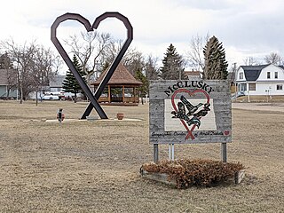
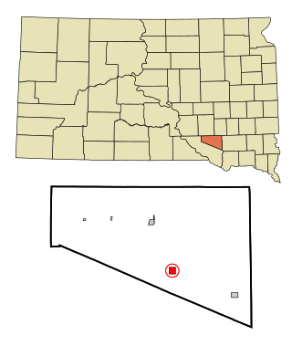
McClusky is a city in Sheridan County, North Dakota, United States. It is the county seat of Sheridan County. The population was 322 at the 2020 census. McClusky was founded in 1905. It is the closest town to the geographical center of North Dakota, which lies approximately five miles to the southwest.

<span class="mw-page-title-main">Park River, North Dakota</span> City in North Dakota, United States

Park River is a city in Walsh County, North Dakota, United States. The population was 1,424 at the 2020 census. Park River was founded in 1884.

<span class="mw-page-title-main">Kenmare, North Dakota</span> City in North Dakota, United States

Kenmare is a city in Ward County, North Dakota, United States. The population was 961 at the 2020 census. Kenmare is part of the Minot Micropolitan Statistical Area.

<span class="mw-page-title-main">Hurdsfield, North Dakota</span> City in North Dakota, United States

Hurdsfield is a city in Wells County, North Dakota, United States. The population was 64 at the 2020 census. Hurdsfield was founded in 1903.

<span class="mw-page-title-main">Armour, South Dakota</span> City in South Dakota, United States

Armour is a city in county seat of Douglas County, South Dakota, United States. The population was 698 at the 2020 census.

<span class="mw-page-title-main">Ipswich, South Dakota</span> City in South Dakota, United States

Ipswich is a city in and county seat of Edmunds County, South Dakota, United States. The population was 928 at the 2020 census.

<span class="mw-page-title-main">Miller, South Dakota</span> City in South Dakota, United States

Miller is a city in and county seat of Hand County, South Dakota, United States. The population was 1,349 at the 2020 census.

<span class="mw-page-title-main">Parkston, South Dakota</span> City in South Dakota, United States

Parkston is a city in Hutchinson County, South Dakota, United States. The population was 1,567 at the 2020 census.

<span class="mw-page-title-main">Crooks, South Dakota</span> City in South Dakota, United States

Crooks is a city in Minnehaha County, South Dakota, United States and is a suburb of Sioux Falls. The population was 1,362 at the 2020 census. Crooks was named New Hope until 1904. The town's present name honors W. A. Crooks, a local politician.

References

  1. "ArcGIS REST Services Directory". United States Census Bureau. Retrieved September 20, 2022.
  2. 1 2 U.S. Geological Survey Geographic Names Information System: Tappen, North Dakota
  3. 1 2 3 "Explore Census Data". United States Census Bureau . Retrieved November 28, 2023.
  4. 1 2 "City and Town Population Totals: 2020-2022". United States Census Bureau. November 28, 2023. Retrieved November 28, 2023.
  5. North Dakota: Counties, Towns & People. Watchmaker Publishing, Ltd. 2008. p. 107. ISBN   978-1-60386-191-5.
  6. "Kidder County". Jim Forte Postal History. Retrieved October 22, 2015.
  7. "US Gazetteer files 2010". United States Census Bureau. Archived from the original on January 12, 2012. Retrieved June 14, 2012.
  8. United States Census Bureau. "Census of Population and Housing" . Retrieved October 30, 2013.
  9. Climate Summary for Tappen, North Dakota