
The Gulf of St. Lawrence fringes the shores of the provinces of Quebec, New Brunswick, Nova Scotia, Prince Edward Island, Newfoundland and Labrador, in Canada, plus the islands Saint-Pierre and Miquelon, possessions of France, in North America.

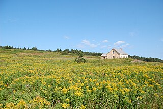
The Magdalen Islands are an archipelago in the Gulf of St. Lawrence. Since 2005, the 12-island archipelago is divided into two municipalities: the majority-francophone Municipality of Îles-de-la-Madeleine and the majority-anglophone Municipality of Grosse-Île, in the Gaspésie–Îles-de-la-Madeleine region, Quebec, Canada.

Les Îles-de-la-Madeleine is a municipality located in Gaspésie-Îles-de-la-Madeleine region, in Quebec, Canada. It is located on the islands of the Magdalen Islands archipelago, in the Gulf of St. Lawrence, 250 km (160 mi) from Gaspé, 120 km (75 mi) from Prince Edward Island, 90 km (56 mi) from Cape Breton Island, and 150 km (93 mi) from Newfoundland.
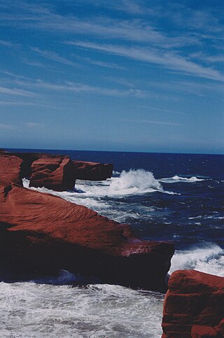
Bonaventure Island is a Canadian island in the Gulf of St. Lawrence located 3.5 km (2.2 mi) off the southern coast of Quebec's Gaspé Peninsula, 5 km (3.1 mi) southeast of the village of Percé. Roughly circular in shape, it has an area measuring 4.16 km2 (1.61 sq mi).

Percé is a city located on the shores of the Gulf of St. Lawrence, near the tip of the Gaspé Peninsula, in Gaspésie-Îles-de-la-Madeleine, Quebec, Canada.
Gaspésie–Îles-de-la-Madeleine is an administrative region of Quebec consisting of the Gaspé Peninsula (Gaspésie) and the Îles-de-la-Madeleine. It lies in the Gulf of Saint Lawrence at the eastern extreme of southern Quebec. The predominant economic activities are fishing, forestry and tourism.

Havre-Saint-Pierre is a municipality located on the north shore of the Gulf of St. Lawrence, in Côte-Nord region, Minganie RCM, Quebec, Canada.

For the city in Quebec, see Sept-Îles, Quebec
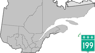
Route 199 is an 84.7 km (52.6 mi) north–south highway located on the Magdalen Islands, in the Gulf of Saint Lawrence. Stretching from Les Îles-de-la-Madeleine's communities of L'Île-du-Havre-Aubert to Grande-Entrée, the route is the main artery of the archipelago and is the only Quebec numbered highway that is detached from the rest of the network.

Cap-aux-Meules (Grindstone) is a former village, now a sector of the municipality of Les Îles-de-la-Madeleine, Quebec. It is located on Cap aux Meules Island, part of the Magdalen Islands archipelago, in the Gulf of St. Lawrence, Quebec, Canada.
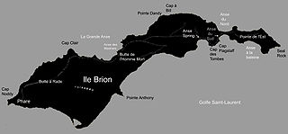
Brion Island is a currently uninhabited island in the Magdalen Islands archipelago in the middle of the Gulf of Saint Lawrence and part of the municipality of Grosse-Île, Gaspésie–Îles-de-la-Madeleine, Quebec, Canada. It is the most northeast of the islands in the Magdalen archipelago, apart from the Bird Rocks twenty kilometres east-north-east.

Île-Bonaventure-et-du-Rocher-Percé National Park is a provincial park of Quebec.
The Communauté maritime des Îles-de-la-Madeleine, commonly designated as the Agglomeration of Les Îles-de-la-Madeleine, is located on the islands of the Magdalen Islands archipelago, that bathes in the waters of the Gulf of St. Lawrence, 250 km from Gaspé, 120 km from Prince Edward Island, 90 km from Cape Breton Island and 150 km from Newfoundland. the municipality of Les Îles-de-la-Madeleine

Placide Vigneau (29 August 1842 − 1 March 1926 was a French Canadian author. He was keeper of the Île aux Perroquets Lighthouse from 1892 to 1912. He kept a journal that is preserved by the Bibliothèque et Archives nationales du Québec.

The Sept Îles Archipelago Regional Park is a proposed protected area in the Côte-Nord region of Quebec, Canada. The islands are important to migratory sea birds, and are also of interest to tourists. The management plan was prepared in 2008.
The Gros-Mécatina Migratory Bird Sanctuary is a protected area in Quebec, Canada. It consists of four islands and a reef in the Gulf of Saint Lawrence that are used as nesting sites by seabirds.

The Île-aux-Perroquets lighthouse is a lighthouse on the Île aux Perroquets in the Mingan Archipelago, Gulf of St. Lawrence, Quebec, Canada. It was built in 1951, replacing an 1888 wooden lighthouse. It received heritage designation in 2014.

Maritime Quebec is a geographic region in eastern Quebec that borders the Gulf of St. Lawrence. It’s made of Gaspesia, Côte-Nord, the Magdalen Islands and Bas-Saint-Laurent.

Havre-Aubert located on Île du Havre Aubert is a village in the municipality of Les Îles-de-la-Madeleine. It is part of the Magdalen Islands archipelago, in the Gulf of St. Lawrence, Quebec, Canada.


 Lighthouse, keepers' house and outbuildings
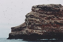 Red sandnestone citadel
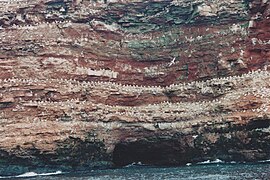 Support one of the six Northern Gannet Colonies in North America [2]


