Rondo, Arkansas

Last updated

Rondo, Arkansas
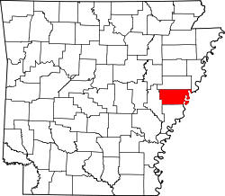
Lee County Arkansas Incorporated and Unincorporated areas Rondo Highlighted 0560590.svg
Location in Lee County, Arkansas
Coordinates: 34°39′27″N90°49′15″W / 34.65750°N 90.82083°W / 34.65750; -90.82083
Country United States
State Arkansas
County Lee
Area
[1]
  Total1.01 sq mi (2.61 km2)
  Land1.01 sq mi (2.61 km2)
  Water0.00 sq mi (0.00 km2)
Elevation
[2]
213 ft (65 m)
Population
 (2020)
  Total163
  Density161.71/sq mi (62.43/km2)
Time zone UTC-6 (Central (CST))
  Summer (DST) UTC-5 (CDT)
FIPS code 05-60590
GNIS feature ID2407239 [2]

Rondo is a town in Lee County, Arkansas, United States. The population was 198 at the 2010 census, [3] down from 237 at the 2000 census.

Contents

Geography

Rondo City Hall building. Rondo City Hall.jpg
Rondo City Hall building.

Rondo is located in southern Lee County 11 miles (18 km) southwest of Marianna, the county seat, via state highways 1 and 121.

According to the United States Census Bureau, the town has a total area of 1.0 square mile (2.6 km2), all land. [3]

Demographics

Historical population
CensusPop.Note
1930 274
1940 201−26.6%
1950 194−3.5%
1960 21912.9%
1970 37973.1%
1980 330−12.9%
1990 283−14.2%
2000 237−16.3%
2010 198−16.5%
2020 163−17.7%
U.S. Decennial Census [4]

2020 census

Rondo, Arkansas – Racial and ethnic composition
Note: the US Census treats Hispanic/Latino as an ethnic category. This table excludes Latinos from the racial categories and assigns them to a separate category. Hispanics/Latinos may be of any race.
Race / Ethnicity (NH = Non-Hispanic)Pop 2000 [5] Pop 2010 [6] Pop 2020 [7] % 20010% 2010% 2020
White alone (NH)59535824.89%26.77%35.58%
Black or African American alone (NH)1661409570.04%70.71%58.28%
Native American or Alaska Native alone (NH)0000.00%0.00%0.00%
Asian alone (NH)0000.00%0.00%0.00%
Pacific Islander alone (NH)0000.00%0.00%0.00%
Some Other Race alone (NH)0000.00%0.00%0.00%
Mixed Race or Multi-Racial (NH)8483.38%2.02%4.91%
Hispanic or Latino (any race)4121.69%0.51%1.23%
Total237198163100.00%100.00%100.00%

As of the census [8] of 2000, there were 237 people, 99 households, and 69 families residing in the town. The population density was 90.6/km2 (235.6/mi2). There were 113 housing units at an average density of 43.2/km2 (112.4/mi2). The racial makeup of the town was 26.16% White, 70.04% Black or African American, and 3.80% from two or more races. 1.69% of the population were Hispanic or Latino of any race.

There were 99 households, out of which 24.2% had children under the age of 18 living with them, 36.4% were married couples living together, 32.3% had a female householder with no husband present, and 30.3% were non-families. 28.3% of all households were made up of individuals, and 15.2% had someone living alone who was 65 years of age or older. The average household size was 2.39 and the average family size was 2.90.

In the town, the population was spread out, with 25.7% under the age of 18, 6.8% from 18 to 24, 22.4% from 25 to 44, 27.4% from 45 to 64, and 17.7% who were 65 years of age or older. The median age was 42 years. For every 100 females, there were 76.9 males. For every 100 females age 18 and over, there were 69.2 males.

The median income for a household in the town was $15,000, and the median income for a family was $26,250. Males had a median income of $25,000 versus $16,667 for females. The per capita income for the town was $13,601. About 32.7% of families and 38.7% of the population were below the poverty line, including 48.6% of those under the age of eighteen and 46.7% of those 65 or over.

Education

It is in the Lee County School District, based in Marianna. [9] The local high school is Lee High School.

See also

Related Research Articles

<span class="mw-page-title-main">Lee County, Arkansas</span> County in Arkansas, United States

Lee County is a county located in the U.S. state of Arkansas. With its eastern border formed by the Mississippi River, it is considered to be part of the Arkansas Delta. As of the 2020 census, the population was 8,600. The county seat is Marianna.

<span class="mw-page-title-main">West Crossett, Arkansas</span> CDP in Arkansas, United States

West Crossett is a census-designated place (CDP) in Ashley County, Arkansas, United States. Per the 2020 census, the population was 1,144.

<span class="mw-page-title-main">Harrell, Arkansas</span> Town in Arkansas, United States

Harrell is a town in Calhoun County, Arkansas, United States. The population was 254 at the 2010 census. It is part of the Camden Micropolitan Statistical Area.

<span class="mw-page-title-main">Anthonyville, Arkansas</span> Town in Arkansas, United States

Anthonyville is a town in Crittenden County, Arkansas, United States. The population was 161 at the 2010 census, down from 250 in 2000.

<span class="mw-page-title-main">Edmondson, Arkansas</span> Town in Arkansas, United States

Edmondson is a town in Crittenden County, Arkansas, United States. The population was 427 at the 2010 census.

<span class="mw-page-title-main">Gilmore, Arkansas</span> City in Arkansas, United States

Gilmore is a city in Crittenden County, Arkansas, United States. Per the 2020 census, the population was 176.

<span class="mw-page-title-main">Aubrey, Arkansas</span> Town in Arkansas, United States

Aubrey is a town in Lee County, Arkansas, United States. The population was 108 at the 2020 census.

<span class="mw-page-title-main">Haynes, Arkansas</span> Town in Arkansas, United States

Haynes is a town in Lee County, Arkansas, United States. The population was 150 at the 2010 census, down from 214 at the 2000 census.

<span class="mw-page-title-main">Victoria, Arkansas</span> Town in Arkansas, United States

Victoria is a town in Mississippi County, Arkansas, United States. The population was 20 as of the 2020 census, down from 37 in 2010. It is named after a sister of the town's founder, Robert E. Lee Wilson.

<span class="mw-page-title-main">Bluff City, Arkansas</span> Town in Arkansas, United States

Bluff City is an unincorporated town in Nevada County, Arkansas, United States. The population was 158 at the 2000 census. It is part of the Hope Micropolitan Statistical Area.

<span class="mw-page-title-main">Reader, Arkansas</span> Census-designated place in Arkansas, United States

Reader is an unincorporated census-designated place in Nevada and Ouachita counties in the U.S. state of Arkansas. As of the 2010 census, its population is 66. Per the 2020 census, the population was 40.

<span class="mw-page-title-main">Fredonia (Biscoe), Arkansas</span> City in Arkansas, United States

Fredonia (Biscoe) is a city in Prairie County, Arkansas, United States. The population was 363 at the 2010 census.

<span class="mw-page-title-main">Greenwood, Florida</span> Town in Florida, United States

Greenwood is a town in Jackson County, Florida, United States. It is part of the Florida Panhandle and located in North Florida, specifically Northwest Florida. The population was 539 at the 2020 census.

<span class="mw-page-title-main">Malone, Florida</span> Town in the state of Florida, United States

Malone is a town in Jackson County, Florida, United States. The population was 1,959 at the 2020 census.

<span class="mw-page-title-main">Tangelo Park, Florida</span> Census-designated place in Florida, United States

Tangelo Park is a census-designated place and an unincorporated area in Orange County, Florida, United States. The population was 2,231 at the 2010 census. It is part of the Orlando–Kissimmee Metropolitan Statistical Area.

<span class="mw-page-title-main">Tildenville, Florida</span> Census-designated place in Florida, United States

Tildenville is a census-designated place (CDP) and an unincorporated area in Orange County, Florida, United States. The population was 511 at the 2010 census, most of them African American. It is part of the Orlando–Kissimmee Metropolitan Statistical Area. Generally speaking, Tildenville is a narrow area alongside Orange County Road 545, south of Florida State Road 50 and north of the Stoneybrook West planned unit development. Residents utilize Winter Garden, Florida for mail delivery. The CDP takes its name from Luther F. Tilden, a prominent pioneer and citrus magnate who greatly contributed to the community. Historically, Tildenville referred to an area larger than the modern CDP. Landmarks such as Tildenville Elementary School, Tildenville Marketplace, and Meadow Marsh are now located within the city limits of Winter Garden.

Limestone Creek is a census-designated place (CDP) in Palm Beach County, Florida, United States. It is part of the Miami metropolitan area of South Florida. The population was 1,316 at the 2020 US census.

<span class="mw-page-title-main">Midway, Seminole County, Florida</span> Place in Florida, United States

Midway is an unincorporated community and census designated place (CDP) in Seminole County, Florida, United States. The population was 1,524 at the 2020 census. It is part of the Orlando–Kissimmee–Sanford Metropolitan Statistical Area.

<span class="mw-page-title-main">Pierson, Florida</span> Town in the state of Florida, United States

Pierson is a town in Volusia County, Florida, United States. The town is part of the Deltona–Daytona Beach–Ormond Beach, Florida Metropolitan Statistical Area. The population was 1,542 as of the 2020 census.

Sulphur Springs, also known as White Sulphur Springs, is a census-designated place (CDP) in Spring Township, Jefferson County, Arkansas, United States. Per the 2020 census, the population was 1,032.

References

  1. "2020 U.S. Gazetteer Files". United States Census Bureau. Retrieved October 29, 2021.
  2. 1 2 U.S. Geological Survey Geographic Names Information System: Rondo, Arkansas
  3. 1 2 "Geographic Identifiers: 2010 Census Summary File 1 (G001), Rondo town, Arkansas". American FactFinder. U.S. Census Bureau. Archived from the original on February 13, 2020. Retrieved August 23, 2019.
  4. "Census of Population and Housing". Census.gov. Retrieved June 4, 2015.
  5. "P004 Hispanic or Latino, and Not Hispanic or Latino by Race – 2000: DEC Summary File 1 – Rondo town, Arkansas". United States Census Bureau .
  6. "P2 Hispanic or Latino, and Not Hispanic or Latino by Race – 2010: DEC Redistricting Data (PL 94-171) – Rondo town, Arkansas". United States Census Bureau .
  7. "P2 Hispanic or Latino, and Not Hispanic or Latino by Race – 2020: DEC Redistricting Data (PL 94-171) – Rondo town, Arkansas". United States Census Bureau .
  8. "U.S. Census website". United States Census Bureau . Retrieved January 31, 2008.
  9. "SCHOOL DISTRICT REFERENCE MAP (2010 CENSUS): Lee County, AR" (PDF). U.S. Census Bureau . Retrieved February 27, 2021.