Rosendale, Missouri

Last updated

Rosendale, Missouri
Rosendale-limits.jpg
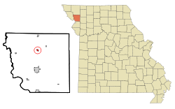
Andrew County Missouri Incorporated and Unincorporated areas Rosendale Highlighted.svg
Location of Rosendale, Missouri
Coordinates: 40°02′27″N94°49′24″W / 40.04083°N 94.82333°W / 40.04083; -94.82333
Country United States
State Missouri
County Andrew
Area
[1]
  Total
0.30 sq mi (0.79 km2)
  Land0.29 sq mi (0.76 km2)
  Water0.01 sq mi (0.03 km2)
Elevation
[2]
919 ft (280 m)
Population
 (2020)
  Total
119
  Density406.14/sq mi (156.86/km2)
Time zone UTC-6 (Central (CST))
  Summer (DST) UTC-5 (CDT)
ZIP code
64483
Area code 816
FIPS code 29-63200 [3]
GNIS feature ID2396434 [2]

Rosendale is a city in Andrew County, Missouri, United States. The population was 119 at the 2020 census.

Contents

Rosendale is part of the St. Joseph, MO KS Metropolitan Statistical Area.

History

A post office called Rosendale has been in operation since 1869. [4] The city was named for the abundance of wild roses near the original town site. [5]

Geography

Rosendale is located on the east bank of the One Hundred and Two River.

According to the United States Census Bureau, the city has a total area of 0.30 square miles (0.78 km2), of which 0.29 square miles (0.75 km2) is land and 0.01 square miles (0.03 km2) is water. [6]

Demographics

Historical population
CensusPop.Note
1880 128
1890 288125.0%
1900 44855.6%
1910 359−19.9%
1920 329−8.4%
1930 322−2.1%
1940 300−6.8%
1950 245−18.3%
1960 234−4.5%
1970 2454.7%
1980 223−9.0%
1990 186−16.6%
2000 180−3.2%
2010 143−20.6%
2020 119−16.8%
U.S. Decennial Census [7]

2010 census

At the 2010 census there were 143 people in 50 households, including 38 families, in the city. The population density was 493.1 inhabitants per square mile (190.4/km2). There were 74 housing units at an average density of 255.2 per square mile (98.5/km2). The racial makup of the city was 98.6% White, 0.7% Native American, and 0.7% from other races. Hispanic or Latino of any race were 0.7%. [8]

Of the 50 households, 38.0% had children under the age of 18 living with them, 62.0% were married couples living together, 12.0% had a female householder with no husband present, 2.0% had a male householder with no wife present, and 24.0% were non-families. 22.0% of households were one person, and 2% were one person aged 65 or older. The average household size was 2.86 and the average family size was 3.37.

The median age was 32.8 years. 31.5% of residents were under the age of 18; 8.4% were between the ages of 18 and 24; 23.8% were from 25 to 44; 24.5% were from 45 to 64; and 11.9% were 65 or older. The gender makeup of the city was 54.5% male and 45.5% female.

2000 census

At the 2000 census there were 180 people in 69 households, including 50 families, in the city. The population density was 578.4 inhabitants per square mile (223.3/km2). There were 76 housing units at an average density of 244.2 per square mile (94.3/km2). The demographics of the city were 99.44% white, 0.56% Hispanic and 0.56% of two or more races. [3]

Of the 69 households, 37.7% had children under the age of 18 living with them, 52.2% were married couples living together, 15.9% had a female householder with no husband present, and 27.5% were non-families. 18.8% of households were one person, and 5.8% were one person aged 65 or older. The average household size was 2.61 and the average family size was 3.06.

In the city the population was spread out, with 30.0% under the age of 18, 9.4% from 18 to 24, 30.6% from 25 to 44, 18.3% from 45 to 64, and 11.7% 65 or older. The median age was 31 years. For every 100 females, there were 97.8 males. For every 100 females age 18 and over, there were 103.2 males.

The median household income was $26,731 and the median family income was $30,313. Males had a median income of $25,179 versus $18,750 for females. The per capita income for the city was $12,847. About 10.2% of families and 11.9% of the population were below the poverty line, including 10.9% of those under the age of eighteen and 20.0% of those 65 or over.

Related Research Articles

<span class="mw-page-title-main">Wheaton, Missouri</span> City in Missouri, United States

Wheaton is a city in Wheaton Township, Barry County, Missouri, United States. The population was 696 at the 2010 census.

<span class="mw-page-title-main">Lamar Heights, Missouri</span> City in Missouri, United States

Lamar Heights is a city in Barton County, Missouri, United States. The population was 170 at the 2020 census.

<span class="mw-page-title-main">Belton, Missouri</span> City in Missouri, US

Belton is a city in northwestern Cass County, Missouri, United States. The population was 23,953 at the 2020 census. It is a part of the Kansas City metropolitan area.

<span class="mw-page-title-main">Freeman, Missouri</span> City in Missouri, United States

Freeman is a city in Cass County, Missouri, United States. The population was 482 at the 2010 census. It is part of the Kansas City metropolitan area.

<span class="mw-page-title-main">Tallapoosa, Missouri</span> City in Missouri, United States

Tallapoosa is a city in New Madrid County, Missouri, United States. The population was 78 at the 2020 census.

<span class="mw-page-title-main">Tracy, Missouri</span> City in Missouri, United States

Tracy is a city in Platte County, Missouri within the United States, located along the Platte River. The population was 269 at the 2020 census. The city is part of the Kansas City metropolitan area.

<span class="mw-page-title-main">Pleasant Hope, Missouri</span> City in Missouri, United States

Pleasant Hope is a city in Polk County, Missouri, United States. The population was 614 at the 2010 census. It is part of the Springfield, Missouri Metropolitan Statistical Area.

<span class="mw-page-title-main">Bella Villa, Missouri</span> City in Missouri, United States

Bella Villa is a city in St. Louis County, Missouri, in the United States. As of the 2010 census, the city population was 729.

<span class="mw-page-title-main">Country Club Hills, Missouri</span> City in Missouri, United States

Country Club Hills is a city in St. Louis County, Missouri, United States. The population was 1,274 at the 2010 census.

<span class="mw-page-title-main">Flordell Hills, Missouri</span> City in Missouri, United States

Flordell Hills is a city in St. Louis County, Missouri, United States. The population was 822 at the 2010 census.

<span class="mw-page-title-main">Jennings, Missouri</span> City in Missouri, United States

Jennings is a city in St. Louis County, Missouri, United States. Per the 2020 census, the population was 12,895.

<span class="mw-page-title-main">Lakeshire, Missouri</span> City in Missouri, United States

Lakeshire is a city in St. Louis County, Missouri, United States. The population was 1,432 at the 2010 census.

<span class="mw-page-title-main">Manchester, Missouri</span> City in Missouri, United States

Manchester is a city in St. Louis County, Missouri, United States. The population was 18,333 at the 2020 census.

<span class="mw-page-title-main">Velda City, Missouri</span> City in Missouri, United States

Velda City is a city in St. Louis County, Missouri, United States. The population was 1,420 at the 2010 census.

<span class="mw-page-title-main">Wildwood, Missouri</span> City in Missouri, United States

Wildwood is a city in St. Louis County, Missouri, United States. It is located in the far western portion of the county. As of the 2020 census, the population was 35,417. Wildwood is the home of the Al Foster Trail, and numerous other trails, parks, and reserves such as Rockwoods Reservation and Babler State Park.

<span class="mw-page-title-main">Woodson Terrace, Missouri</span> City in Missouri, United States

Woodson Terrace is a city in St. Louis County, Missouri, United States. The population was 4,063 at the 2010 census.

<span class="mw-page-title-main">Clarkson Valley, Missouri</span> City in Missouri, United States

Clarkson Valley is a city in St. Louis County, Missouri, United States. The population was 2,609 at the 2020 census.

<span class="mw-page-title-main">Moline Acres, Missouri</span> City in Missouri, United States

Moline Acres is a city in St. Louis County, Missouri, United States. The population was 2,442 at the 2010 census.

<span class="mw-page-title-main">Warson Woods, Missouri</span> City in Missouri, United States

Warson Woods is a city in St. Louis County, Missouri, United States. The population was 1,962 at the 2010 census.

<span class="mw-page-title-main">Rosendale (town), Wisconsin</span>

Rosendale is a town in Fond du Lac County, Wisconsin, United States. The population was 783 at the 2000 census. The village of Rosendale is located partially within the town. The unincorporated communities of Rosendale Center and West Rosendale are also located in the town.

References

  1. "ArcGIS REST Services Directory". United States Census Bureau. Retrieved August 28, 2022.
  2. 1 2 U.S. Geological Survey Geographic Names Information System: Rosendale, Missouri
  3. 1 2 "U.S. Census website". United States Census Bureau . Retrieved January 31, 2008.
  4. "Post Offices". Jim Forte Postal History. Retrieved August 30, 2016.
  5. "Andrew County Place Names, 1928-1945 (archived)". The State Historical Society of Missouri. Archived from the original on June 24, 2016. Retrieved August 30, 2016.{{cite web}}: CS1 maint: bot: original URL status unknown (link)
  6. "US Gazetteer files 2010". United States Census Bureau. Archived from the original on January 25, 2012. Retrieved July 8, 2012.
  7. "Census of Population and Housing". Census.gov. Retrieved June 4, 2015.
  8. "U.S. Census website". United States Census Bureau . Retrieved July 8, 2012.