Sabang, Indonesia

Last updated
Sabang
City
Other transcription(s)
   Jawoë سابڠ
Rubiah Island Aceh.jpg
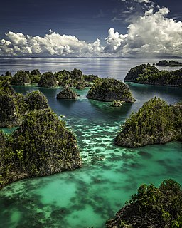
Rubiah Island, Sabang
Lambang Kota Sabang.png
Seal
Lokasi Aceh Kota Sabang.svg
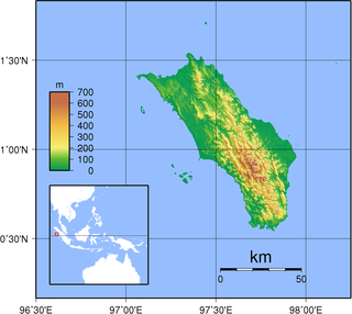
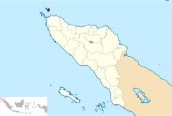
Location within Aceh
Location map Northern Sumatra.png
Red pog.svg
Sabang
Location in Northern Sumatra, Sumatra and Indonesia
Indonesia Sumatra location map.svg
Red pog.svg
Sabang
Sabang (Sumatra)
Indonesia location map.svg
Red pog.svg
Sabang
Sabang (Indonesia)
Coordinates: 5°53′39″N95°19′9″E / 5.89417°N 95.31917°E / 5.89417; 95.31917 Coordinates: 5°53′39″N95°19′9″E / 5.89417°N 95.31917°E / 5.89417; 95.31917
Country Flag of Indonesia.svg  Indonesia
Province Aceh Indonesia Flag.png  Aceh
Government
  Mayor Nazaruddin
  Vice Mayor Suradji
Area[ citation needed ]
  Total 153.00 km2 (59.07 sq mi)
Population (2014 Estimate)
  Total 32,271 [1]
Time zone UTC+7 (Indonesia Western Time)
Area code (+62) 652
Website sabangkota.go.id

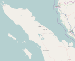
Sabang is a city consisting of a main island (Weh Island) and several smaller islands off the northern tip of Sumatra. The islands form a city within Aceh Special Region, Indonesia. The administrative centre is located on Weh Island, 17 km north of Banda Aceh. The city covers an area of 153.0 square kilometres and according to the 2010 census had a population of 30,653 people; [2] the latest estimate (for January 2014) is 32,271. [1] Sabang is also known as the northernmost and westernmost city of Indonesia.

Sumatra island in western Indonesia, westernmost of the Sunda Islands

Sumatra is a large island in western Indonesia that is part of the Sunda Islands. It is the largest island that is located entirely in Indonesia and the sixth-largest island in the world at 473,481 km2.

Aceh Province in Indonesia

Aceh is a province of Indonesia, located at the northern end of Sumatra. Its capital and largest city is Banda Aceh. It is close to the Andaman and Nicobar Islands of India and separated from them by the Andaman Sea. Granted a special autonomous status, Aceh is a religiously conservative territory and the only Indonesian province practicing Sharia law officially. There are ten indigenous ethnic groups in this region, the largest being the Acehnese people, accounting for approximately 80% to 90% of the region's population.

Indonesia Republic in Southeast Asia

Indonesia, officially the Republic of Indonesia, is a country in Southeast Asia, between the Indian and Pacific oceans. It is the world's largest island country, with more than seventeen thousand islands, and at 1,904,569 square kilometres, the 14th largest by land area and the 7th largest in combined sea and land area. With over 261 million people, it is the world's 4th most populous country as well as the most populous Muslim-majority country. Java, the world's most populous island, contains more than half of the country's population.

Contents

The Japanese occupied the island and installed numerous bunkers, fortifications and gun emplacements. Their remnants can still be seen, though most have been re-purposed or removed. On 6 May 1943, the Imperial Japanese Navy's submarine, the I-29, tasked with a Yanagi mission, landed the Indian leader and freedom fighter, Netaji Subhash Chandra Bose and his lieutenant, Abid Hasan at Sabang on Weh Island, instead of the Penang, to avoid detection by British spies.

I-29, code-named Matsu, was a B1 type submarine of the Imperial Japanese Navy used during World War II on two secret missions with Germany. She was sunk while coming back from the second mission.

The Yanagi missions were a series of submarine voyages undertaken by the Imperial Japanese Navy during the Second World War, to exchange technology, skills and materials with Japan's Axis partners, principally Nazi Germany. These voyages had to run the gauntlet of the western allies naval superiority in the Indian and Atlantic oceans; of the five westbound voyages, three arrived safely, with two submarines sunk en route, while of the three successful vessels only one completed her return voyage, with two sunk before reaching home.

Abid Hasan Safrani, IFS, born Zain-al-Abdin Hasan, was an officer of the Indian National Army and later, after 1947, an Indian diplomat.

Islands

  1. Klah Island (0.186 km²)
  2. Rondo Island (0.650 km²)
  3. Rubiah Island (0.357 km²)
  4. Seulako Island (0.055 km²)
  5. Weh Island (121 km²)

Administrative districts

The city is divided into two districts (kecamatan), listed below with their populations at the 2010 Census:

KecamatanPopulation
at 2010
Census [3]
No. of
Villages
Sukajaya15,54210
Sukakarya15,1118

Villages

Sabang has 18 villages in two districts (Sukajaya and Sukakarya). With the details, Sukajaya has 10 villages and Sukakarya has 8 villages. Listed below with the name of all villages in Sabang with 2016 data:

VillagesKecamatan
PayaSukajaya
KeunekaiSukajaya
BeurawanSukajaya
JaboiSukajaya
BalohanSukajaya
Cot AbeukSukajaya
Cot Ba'uSukajaya
Anoi ItamSukajaya
Ujong KareungSukajaya
Ie MeuleSukajaya
IboihSukakarya
Batee ShokSukakarya
Paya SeunaraSukakarya
Krueng RayaSukakarya
Aneuk LaotSukakarya
Kota Bawah TimurSukakarya
Kota Bawah BaratSukakarya
Kota AtasSukakarya
Gapang Beach, Sabang Gapang Beach, Sabang, Aceh.jpg
Gapang Beach, Sabang

Airport

Sabang is served by the Maimun Saleh Airport. The airport is located southeast of the central city on Weh Island.

Maimun Saleh Airport

Maimun Saleh Airport is a small airport with a runway length of 1,844 m (6,050 ft) and altitude of 120 m (390 ft) in Sabang, Pulau Weh, Indonesia. It is situated on the island right above the northern tip of Sumatra in the Andaman Sea. It is part of the Sabang city in Aceh province. This airport was named after one of Indonesian Air Force pilot, Maimun Saleh, who died in plane crash at Bogor on August, 1952. The airport is considered to be Indonesia's westernmost airport.

International sail tourism event

The City hosted an international sail tourism event in September 2011. The sail race was participated in by around 50 ships with 15 crew members each. Besides sailing they visited interesting places packed in a 'tsunami' tourism, visit Gapang Beach and Iboih Beach with enchanting underwater scenery. [4]

<i>Tsunami</i> Series of water waves caused by the displacement of a large volume of a body of water

A tsunami or tidal wave,, also known as a seismic sea wave, is a series of waves in a water body caused by the displacement of a large volume of water, generally in an ocean or a large lake. Earthquakes, volcanic eruptions and other underwater explosions (including detonations, landslides, glacier calvings, meteorite impacts and other disturbances above or below water all have the potential to generate a tsunami. Unlike normal ocean waves, which are generated by wind, or tides, which are generated by the gravitational pull of the Moon and the Sun, a tsunami is generated by the displacement of water.

Weh Island island in Aceh, Indonesia

Weh Island, often known as Sabang after the largest city, is a small active volcanic island to the northwest of Sumatra, 45 minutes by fast regular ship or 2 hours by ferry from mainland, Banda Aceh. It was originally connected to the Sumatran mainland and became separated by sea after the volcano's last eruption in the Pleistocene era. The island is situated in the Andaman Sea. The largest city on the island, Sabang, is the northernmost outpost of Indonesia.

Sail Sabang 2017 will held from Nov. 28 until Dec. 5 in Sabang. The event is the ninth installment of Sail Indonesia, an annual yacht rally that was first launched in 2009 on Bunaken Island, North Sulawesi. [5]

Sail Indonesia

Sail Indonesia is a series of sailing and other events for yachts conducted each year in Indonesia. The events are organised by Yayasan Cinta Bahari Indonesia (YCBI) and supported by the high-profile tourist destinations to international yachtsmen and women with a view to expanding the tourism potential and raising awareness of the region as well as introducing visitors to natural and cultural features of the Indonesian archipelago that they might otherwise not visit.

North Sulawesi Province in Indonesia

North Sulawesi is a province of Indonesia. It is located on the northern peninsula of the island of Sulawesi, on the Minahasa Peninsula, lies south of Philippines and southeast of Malaysia. It borders Philippines to the north, the Maluku Sea to the east, Gorontalo to the west and the Gulf of Tomini to the south. The province's capital and largest city is Manado, and its population was 4,135,526 according to the 2010 census; the latest official estimate is 4,353,540. Manado is also the main gateway and the economic center of the province. Other major towns includes Tomohon and Bitung. There are 41 mountains with an altitude ranging from 1,112–1,995 metres (3,648–6,545 ft). Most geologic conditions are the young volcanic region, a large number of eruptions and the active cone shape of the active volcanoes that adorn the central Minahasa, Bolaang Mongondow and Sangihe Islands.

See also

Related Research Articles

Madura Island island in Indonesia

Madura is an Indonesian island off the northeastern coast of Java. The island comprises an area of approximately 4,078.67 km². Madura is administered as part of the East Java province. It is separated from Java by the narrow Strait of Madura. The administered area has a density of 702 people per km², while that of the island itself is higher at 817/km².

North Sumatra Province in Indonesia

North Sumatra is a province of Indonesia. It is located in the northwest of the island of Sumatra, and its capital is Medan. North Sumatra is the fourth most populous province in Indonesia after West Java, East Java and Central Java and the most populous Indonesian province outside Java, with over 13.5 million inhabitants in 2014.

Tourism in Indonesia

Tourism in Indonesia is an important component of the Indonesian economy as well as a significant source of its foreign exchange revenues. Indonesia was ranked at 20th in the world tourist Industry in 2017, also ranked as the ninth-fastest growing tourist sector in the world, the third-fastest growing in Asia and fastest-growing in Southeast Asia.The country has planned to achieve 8 percent of GDP from tourism sector and targeted to attract about 20 million of visitors by 2019. The tourism sector ranked as the 4th largest among goods and services export sectors.

Banda Aceh City in Aceh, Indonesia

Banda Aceh is the capital and largest city in the province of Aceh, Indonesia. It is located on the island of Sumatra and has an elevation of 35 meters. The city covers an area of 64 square kilometres and had a population of 219,070 people, according to the 2000 census. Banda Aceh is located on the northwestern tip of Indonesia at the mouth of the Aceh River.

Jabodetabek Place in Indonesia

Jabodetabek or Greater Jakarta is an official and administrative definition of the urban area or megacity surrounding the Indonesia capital city, Jakarta. The original term "Jabotabek" dated from the late 1970s and was revised to "Jabodetabek" in 1999 when "De" was inserted into the name following its formation. It finally included DKI Jakarta, five cities and three regencies.

Nias island in Indonesia

Nīas is an island located off the western coast of Sumatra, Indonesia. Nias is also the name of the archipelago of which the island is the centre, but also includes the Batu Islands to the south-east and the small Hinako Islands to the west. Nias Island covers an area of 5,121.3 km2 (1,977.3 sq mi). It is mostly a lowland area rising to around 800 m (2,600 ft) above sea level. There were 756,338 inhabitants on the island at the 2010 Census. The latest estimate for January 2014 is 788,132.

Great Nicobar Island island in India

Great Nicobar is the southernmost and largest of the Nicobar Islands of India, north of Sumatra.

Tangerang City in Banten, Indonesia

Tangerang is a city in the province of Banten, Indonesia. Located on the western border of Jakarta, it is the third largest urban centre in the Greater Jakarta metropolitan area after Jakarta and Bekasi; the sixth largest city proper in the nation; and the largest city in Banten province. It has an area of 164.54 square kilometres and an official 2010 Census population of 1,797,715, increasing to 2,001,925 as at 2014 — making it the eighth most populated suburb in the world at the latter date.

Aceh Besar Regency Regency in Sumatra, Indonesia

Aceh Besar Regency is a regency of Aceh Special Territory, Indonesia. The Regency covers an area of 2,969 square kilometres and according to the 2010 census had a population of 351,418; the latest official estimate is 369,972. The Regency is located at the northwest tip of Sumatra island and surrounds the provincial capital of Banda Aceh. The seat of the Regency government is Jantho. The regency is divided into 23 districts with 618 villages.

Samarinda City in East Kalimantan, Indonesia

Samarinda is the capital of the Indonesian province of East Kalimantan on the island of Borneo. The city lies on the banks of the Mahakam River. It is the most populous city on the entire Borneo island, with an estimated population of 842,691, up from 726,223 at the 2010 Census. Although it is the capital of East Kalimantan, some government institutions such as the Police, Indonesian Army District VI Of Tanjung Pura, and Pelabuhan Indonesia are located on the island. Samarinda is known for its traditional food amplang, as well as the cloth sarung samarinda. The city also has a bridge connecting its river banks, Mahakam Bridge. The city center is on one side and the other side is named Samarinda Seberang.

Indira Point Village in Andaman and Nicobar Islands, India

Indira Point is a village in the Nicobar district at Great Nicobar Island of Andaman and Nicobar Islands in India. It is located in the Great Nicobar tehsil. It was the location of the southernmost point of India's territory.

Dumai City in Riau

Dumai, is a city in Riau province on the island of Sumatra, Indonesia. The city has an area of 2,039.35 km² and has 316,668 inhabitants in 2014. Dumai has a domestic airport, that is Pinang Kampai Airport. Dumai is an important transport and trade centre, both regionally and internationally, especially to Malaysia. Dumai is rich in oil.

Bogor Regency Regency in West Java, Indonesia

Bogor Regency is a regency (kabupaten) of West Java, Indonesia, south of DKI Jakarta. It is considered a bedroom community for Jakarta, and is home to over five million people. Its administration is located in Cibinong.

Lhokseumawe City in Sumatra, Indonesia

Lhokseumawe, is the second largest city in Aceh Special District, in the north of Sumatra, Indonesia. The city covers an area of 181.06 square kilometres, and had a population of 171,163 at the 2010 Census; the latest official estimate is 180,200. Being between Banda Aceh and the large southern city of Medan, the town is a key regional centre important for the economy of Aceh.

Rondo Island is an outlying island of Indonesia and the country's northernmost island. It has an area of 0.650 km². It is part of the Aceh province of Sumatra. Administratively this island is part of the city of Sabang, located on Weh Island south of Rondo. It borders India's Great Nicobar Island of the Nicobar Islands approximately 163 km to the north. Indira Point on Great Nicobar Island is India's southernmost land border and Rondo Island is Indonesia's

References

  1. 1 2 http://www.depkes.go.id/downloads/Penduduk%20Kab%20Kota%20Umur%20Tunggal%202014.pdf Estimasi Penduduk Menurut Umur Tunggal Dan Jenis Kelamin 2014 Kementerian Kesehatan
  2. Seta,William J. Atlas Lengkap Indonesia dan Dunia (untuk SD, SMP, SMU, dan Umum). Pustaka Widyatama. p. 7. ISBN   979-610-232-3.
  3. Biro Pusat Statistik, Jakarta, 2011.
  4. RH, Priyambodo (28 May 2011). "Sabang to host sail tourism event in September". antaranews.com. Retrieved 13 December 2013.
  5. "Sail Sabang 2017 aims to put Aceh on global tourism map". The Jakarta Post. Retrieved 22 November 2017.