Saint-Louis-de-Kent, New Brunswick

Last updated

Saint-Louis-de-Kent
Saint-Louis de Kent
St-Louis-de-Kent NB.JPG
A huge Acadian flag dominates St-Louis' skyline
Saint-Louis-de-Kent NB logo.png
Motto: 
Le berceau du drapeau acadien
Canada New Brunswick location map 2.svg
Red pog.svg
Saint-Louis-de-Kent
Location within New Brunswick
Coordinates: 46°44′17″N64°58′26″W / 46.738°N 64.974°W / 46.738; -64.974
CountryCanada
Province New Brunswick
County Kent County
Town Beaurivage
Founded1797
VillageNovember 9, 1966
Area
[1]
  Land1.98 km2 (0.76 sq mi)
Population
 (2021) [1]
  Total981
  Density494.6/km2 (1,281/sq mi)
  Change (2016–21)
Increase2.svg 14.6%
Time zone UTC−4 (AST)
  Summer (DST) UTC−3 (ADT)
Area code 506

Saint-Louis-de-Kent [lower-alpha 1] is a former village in Kent County, New Brunswick, Canada. It held village status prior to 2023 and is now part of the town of Beaurivage.

Contents

Often shortened to simply Saint-Louis, the village is situated on the Kouchibouguacis River at the main entrance to Kouchibouguac National Park. It is considered as the birthplace of the Acadian Flag. A local park, parc des forgeron, celebrates the birth of this flag in 1884.

History

Saint-Louis-de-Kent was founded by Joseph Babineau in 1797. [2] L'Académie Saint-Louis was founded in 1874 by Father Marcel-François Richard. The Congregation of Notre-Dame of Montréal founded a convent in 1879. The academy became a college in 1876, but it was closed in 1882 by Bishop James Rogers. Additional facilities included a telephone line between Quebec and Halifax.

A religious Grotto and Calvary was erected next to the Kouchibouguacis River between 1878 and 1882, and remains an important Acadian pilgrimage site. It was declared a Heritage Site in 2005. [3]

The Saint-Louis Caisse Populaire was founded in 1938. L'École Mgr-Marcel-François-Richard was opened in 1978.

On 1 January 2023, Saint-Louis-de-Kent amalgamated with the town of Richibucto and all or part of for local service districts to form the new town of Beaurivage. [4] [5] The community's name remains in official use. [6]

Demographics

The Kouchibouguacis River flows through St. Louis de Kent. This bridge was replaced with a modern structure over a 3-year construction period, and opened in 2016. KouchibouguacisAtBridge.jpg
The Kouchibouguacis River flows through St. Louis de Kent. This bridge was replaced with a modern structure over a 3-year construction period, and opened in 2016.

In the 2021 Census of Population conducted by Statistics Canada, Saint-Louis de Kent had a population of 981 living in 424 of its 452 total private dwellings, a change of

Population trend [9] [10]

CensusPopulationChange (%)
2021981Increase2.svg14.6%
2016856Decrease2.svg8.0%
2011930Decrease2.svg3.1%
2006960Decrease2.svg3.2%
2001991Decrease2.svg2.4%
19961,015Decrease2.svg0.6%
19911,009Decrease2.svg8.4%
19861,101Decrease2.svg5.9%
19811,166N/A

Notable people

See also

Notes

  1. Written Saint-Louis de Kent in successive regulations defining the province's municipalities, the common form with three hyphens was normally used even by other provincial government departments.

Related Research Articles

<span class="mw-page-title-main">Dieppe, New Brunswick</span> City in New Brunswick, Canada

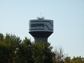
Dieppe is a city in the Canadian maritime province of New Brunswick. Statistics Canada counted the population at 28,114 in 2021, making it the fourth-largest city in the province. On 1 January 2023, Dieppe annexed parts of two neighbouring local service districts; revised census figures have not been released.

<span class="mw-page-title-main">Gagetown, New Brunswick</span> Place in New Brunswick, Canada

Gagetown is a former village in Queens County, New Brunswick, Canada. It held village status prior to 2023 and is now part of the village of Arcadia. It is on the west bank of the Saint John River and is the county's shire town.

<span class="mw-page-title-main">Rexton, New Brunswick</span> Place in New Brunswick, Canada

Rexton is a former village in Kent County, New Brunswick, Canada. It was a village in its own right until the end of 2022 and is now part of the village of Five Rivers.

<span class="mw-page-title-main">Shippagan</span> Town in New Brunswick, Canada

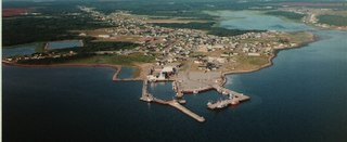
Shippagan is a Canadian town within Shippegan Parish, Gloucester County, New Brunswick.

<span class="mw-page-title-main">Saint-Quentin, New Brunswick</span> Town in New Brunswick, Canada

Saint-Quentin is a town in northern New Brunswick, Canada.

<span class="mw-page-title-main">Rogersville, New Brunswick</span> Place in New Brunswick, Canada

Rogersville is a former village in Northumberland County, New Brunswick, built around the Intersection of New Brunswick Route 126 and New Brunswick Route 440. It was an incorporated village until the end of 2022 and is now part of the village of Nouvelle-Arcadie.

<span class="mw-page-title-main">Saint-Antoine, New Brunswick</span> Place in New Brunswick, Canada

Saint-Antoine is a former village in Kent County, New Brunswick, Canada. It is 35 km north of Moncton and 18 km Southwest of Bouctouche. Saint-Antoine is on Route 115 and Route 525. It is now part of the town of Champdoré.

<span class="mw-page-title-main">Richibucto Parish, New Brunswick</span> Parish in New Brunswick, Canada

Richibucto is a geographic parish in Kent County, New Brunswick, Canada.

<span class="mw-page-title-main">Lamèque</span> Place in New Brunswick, Canada

Lamèque is a former town in Gloucester County, New Brunswick, Canada. It held town status prior to 2023 and is now part of the town of Île-de-Lamèque.

Maisonnette is a former village in Gloucester County, New Brunswick, Canada. It held village status prior to 2023 but is now part of the town of Rivière-du-Nord.

<span class="mw-page-title-main">Grande-Anse, New Brunswick</span> Place in New Brunswick, Canada

Grande-Anse is a former village in Gloucester County, New Brunswick, Canada. It held village status prior to 2023 and is now part of the town of Rivière-du-Nord.

<span class="mw-page-title-main">Saint-Isidore, New Brunswick</span> Place in New Brunswick, Canada

Saint-Isidore is a former village in Gloucester County, New Brunswick, Canada. It held village status prior to 2023 and is now part of the town of Hautes-Terres. It is adjacent to the communities of Pont-Landry, Hacheyville, Bois-Gagnon and Tilley Road. The community is situated on the Acadian Peninsula.

Saint-Léolin is a former village on the Acadian Peninsula in Gloucester County, New Brunswick, Canada. It held village status prior to 2023 and is now part of the town of Rivière-du-Nord.

Sainte-Marie-Saint-Raphaël is a former village in Gloucester County, New Brunswick, Canada. It held village status prior to 2023 and is now part of the town of Île-de-Lamèque.

<span class="mw-page-title-main">Saint-Louis Parish, New Brunswick</span> Parish in New Brunswick, Canada

Saint-Louis is a geographic parish in Kent County, New Brunswick, Canada.

<span class="mw-page-title-main">Saint-Charles Parish, New Brunswick</span> Parish in New Brunswick, Canada

Saint-Charles is a geographic parish in Kent County, New Brunswick, Canada.

<span class="mw-page-title-main">Caraquet</span> Town in New Brunswick, Canada

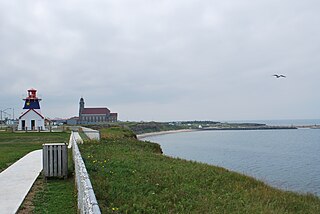
Caraquet is a town in Gloucester County, New Brunswick, Canada.

<span class="mw-page-title-main">Grand-Bouctouche</span> Place in New Brunswick, Canada

Grand-Bouctouche is a Canadian town in Kent County, New Brunswick.

<span class="mw-page-title-main">Richibucto</span> Place in New Brunswick, Canada

Richibucto is a former town in Kent County, New Brunswick, Canada. It held town status prior to 2023 and is now part of the town of Beaurivage.

Haut-Madawaska is a town in the New Brunswick Panhandle, Canada, formed by amalgamating the previous incorporated rural community of the same name with the village of Lac Baker. The town includes the former incorporated villages of Lac Baker, Baker-Brook, Clair, Saint-François de Madawaska and Saint-Hilaire.

References

  1. 1 2 3 "Census Profile of Saint-Louis-de-Kent, Village (VL)". Statistics Canada. 6 December 2022. Retrieved 21 January 2023.
  2. "The Village's Foundation". Saint-Louis-de-. Archived from the original on 2011-07-06. Retrieved 2009-09-28.
  3. Historica.ca Grotto and Calvary. Accessed July 15, 2019.
  4. "Local Governments Establishment Regulation – Local Governance Act". Government of New Brunswick. 12 October 2022. Retrieved 21 January 2023.
  5. "RSC 6 Kent Regional Service Commission". Government of New Brunswick. Retrieved 21 January 2023.
  6. "Proposed entity names reflect strong ties to nature and history" (Press release). Irishtown, New Brunswick: Government of New Brunswick. 25 May 2022. Retrieved 21 January 2023.
  7. CBC News (23 November 2012). Saint-Louis-de-Kent bridge to be replaced. Accessed July 15, 2019.
  8. News Release (1 September 2016). "New bridge open on Route 134". Government of New Brunswick. Retrieved 1 August 2019.
  9. Statistics Canada: 1996, 2001, 2006 census
  10. "Census Profile, 2016 Census Saint-Louis de Kent, Village [Census subdivision], New Brunswick". Statistics Canada. Retrieved September 13, 2019.