
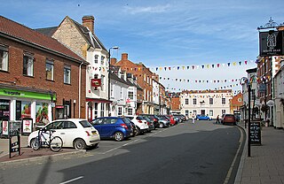
Alcester is a market town and civil parish in the Stratford-on-Avon District in Warwickshire, England. It is 8 mi (13 km) west of Stratford-upon-Avon, and 7 miles south of Redditch. The town dates back to the times of Roman Britain and is located at the junction of the River Alne and River Arrow.
Shipston-on-Stour is a town and civil parish in the Stratford-on-Avon District in southern Warwickshire, England. It is located on the banks of the River Stour, 9 miles (15 km) south-southeast of Stratford-upon-Avon, 10 miles north-northwest of Chipping Norton, 14 miles (22 km) south of Warwick and 14.5 miles west of Banbury. In the 2021 census, Shipston-on-Stour had a population of 5,849.

Bidford-on-Avon is a large village and civil parish in the English county of Warwickshire, very close to the border with Worcestershire. In the 2001 census it had a population of 4,830, increasing to 5,350 at the 2011 census, increasing again to 6,818 in the 2021 census.
Abbot's Salford is the name of a village in the English county of Warwickshire. It is found six miles south of Alcester, about the same distance from Evesham, very close to the Worcestershire border, and is within the parish of Salford Priors. The River Avon runs close by the eastern side of the village. As well as the hotel the modest modern attractions of the village seem to be Abbot's Salford Lake, which is an excellent fishing spot, and a caravan park.

Barford is a village and civil parish in the Warwick district of Warwickshire, England, about three miles south of Warwick. As at the 2001 census the parish had a population of 1,171, that increased to 1,336 at the 2011 census. The Joint parish council also runs the villages of Sherbourne and Wasperton. In March 2014 "The Sunday Times" listed the village as one of the Top 10 places to live in The Midlands. In the village there are two pubs, a hotel with swimming pool, and a village shop owned and run by the community.
Binton is a village and civil parish in the Stratford district of Warwickshire, England. It is about five miles (8.0 km) west of Stratford-upon-Avon. According to the 2001 census it had a population of 272, increasing to 311 at the 2011 census.

Mickleton is a village and civil parish in the Cotswold District of Gloucestershire, England. The village is the northernmost settlement in Gloucestershire, lying close to the borders with Worcestershire and Warwickshire, 3 miles (4.8 km) north of Chipping Campden, 8 miles (13 km) east of Evesham and 8 miles (13 km) south of Stratford-upon-Avon. The population of the parish was 1,677 at the 2011 Census.

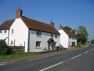
Kinwarton is a village in the valley of the River Alne, Warwickshire, to the north-east of the market town of Alcester. The population of the civil parish at the 2011 Census was 1,082. The ground is mostly low-lying, with a maximum altitude of 206 ft. and some of the fields near the river are liable to floods. The road from Alcester to Henley-in-Arden runs through the middle of the parish. A branch road leads off to the church and rectory about a quarter of a mile to the south and thence continues as a field-path down to a ford across the River Alne below Hoo Mill. From the north side of the main road a by-road branches off to Coughton.

Sambourne, formerly spelled Sambourn, is a village and civil parish 1.5 miles (2.4 km) north-west of Coughton, 4.5 miles (7.2 km) south of Redditch, 12 miles (19 km) north-west of Stratford-upon-Avon and 20 miles (32 km) west of Warwick in the county of Warwickshire, England. It is situated on sloping ground rising westwards to about 500 feet near the ancient Ridge Way, and forms part of the county boundary with Worcestershire. The village itself is centred round a small triangular green at the junction of four roads and contains several timber-framed buildings of 17th century date. By a designation of 22 July 1991 much of the central area became a conservation area.

Temple Grafton is a village and civil parish in the Stratford-on-Avon district of Warwickshire, England, situated about 4 miles (6.4 km) east of Alcester and 14 miles (23 km) west of the county town of Warwick. The place name is misleading, the Knights Templar never having any association with the place but owing to a naming error made in the time of Henry VIII the mistake has been perpetuated. During the reign of Richard I the estate in fact belonged to the Knights Hospitaller. During the reign of Edward III in 1347 the village was recorded as Grafton Superior while neighbouring Ardens Grafton was named Inferior.

Wixford is a hamlet and civil parish in the Stratford-on-Avon District of Warwickshire, England, situated 1.5 miles (2.4 km) south of Alcester. The population at the 2011 census was 155. The area is largely agricultural with no large employers in the area, most residents commuting to larger towns nearby.
Luddington is a small village and civil parish in the English county of Warwickshire and is part of Stratford-on-Avon district. The community is a conservation area due to its historic aspects. In 2001, the population was 457, increasing to 515 at the 2021 census. It is located about 5 kilometres outside the town of Stratford-upon-Avon on the banks of the river Avon and has views south over the Cotswolds. Facilities and communications include a phone box, a 19th-century church, a post box, a marina with a 17th-century lock, a village green and a recently refurbished village hall originally built in 1953. The parish encompasses Dodwell Caravan Park to the north of the village. The village is reputed to be the meeting place of Anne Hathaway and William Shakespeare, as Anne was from the parish, and local lore states that they probably conducted their courtship in the area.

Church Lench is a village and former civil parish, now in the parish of South Lenches, in the Wychavon district, in the county of Worcestershire, England, approximately 5.5 miles due north of Evesham and 13 miles due west of Stratford-upon-Avon. It is the largest of the surrounding Lenches, accommodating the Lenches Sports Club, the Lenches Members' Club, Church Lench First School, Church Lench preschool and the Church Lench Village Hall.

Harvington is a village near Evesham in Worcestershire, England. Bounded by the River Avon to the south and the Lench Hills to the north, three miles northeast of Evesham and now on the Worcestershire/Warwickshire border. The village today is an amalgamation of two smaller villages, Harvington and Harvington Cross, and has a population of around 1,750.
Ardens Grafton is a hamlet or small village in the Stratford-on-Avon District of Warwickshire, England, situated about 4 miles (6.4 km) east of Alcester and 14 miles (23 km) west of the county town of Warwick. It has a main street and consists mostly of houses constructed of local stone with tiled roofs, with the exception of two properties, 'Manor Cottage' and 'Chapel House' both of which have timber-framed walls and a thatched roof. Two other buildings retain fragments of ancient framing. During the reign of Edward III in 1347 the village was recorded as Grafton Inferior while neighbouring Temple Grafton, 0.50 miles (0.80 km) to the East, was named Superior Other designations used during the Middle Ages were Nether Grafton, Grafton Inferior or Grafton Minor whilst the larger village of Temple Grafton was distinguished as Over Grafton, Grafton Superior, Church Grafton, or Grafton Major. A reference to 'Temple Grafton alias Ardens Grafton' occurs in 1650.

Moreton Morrell is a village and civil parish in the county of Warwickshire, England. It is part of the historic hundred of Kington and is located about three and a half miles north west of the village of Kineton. The settlement was first mentioned in the Domesday Book as Moreton. From at least Norman times, it has consisted of the village of Moreton and the hamlet of Morrell. The parish of Moreton Morrell is bounded on the east and south east by the Fosse Way, and consists of Little Morrell in the north, the village of Moreton Morrell, and Moreton Paddox in the south.

Exhall is a village and civil parish about 1+1⁄4 miles (2 km) south-south-east of Alcester in the Stratford-on-Avon district of Warwickshire, England. Its parish includes the hamlet of Little Britain and part of Ardens Grafton, the greater part of which is in the neighbouring civil parish of Temple Grafton. The 2011 Census recorded Exhall parish's population as 203. Exhall is on Hay Brook, a tributary of the River Arrow. The civil parish neighbours those of Alcester and Wixford, with which it shares both an ecclesiastical parish and a cricket club.
Broom is a village in the civil parish of Bidford-on-Avon in the Stratford-on-Avon district of Warwickshire, England, about 1.7 miles (2.7 km) north-west of Bidford. The village lies in the north-west corner of the parish between the River Avon, which forms its western boundary, and the road from Bidford to Alcester. Broom formerly consisted of two hamlets known as King's Broom and Burnell's Broom. Burnell's Broom, the southern portion, was said to have been depopulated by Sir Rice Griffin of Broom Court during the reign of Elizabeth I. At the 2011 census Broom has a population of 550

Milcote is a village and former civil parish, now in the parish of Clifford Chambers and Milcote, in the Stratford-on-Avon district, in Warwickshire, England. It falls within the ecclesiastical parish of All Saints Church. It was made up of Upper Milcote or Milcote-on-Stour, site of Mount Grevill manor, and Lower Milcote or Milcote-on-Avon. Milcote was one of the estates which Ceolred of Mercia is said to have granted to Evesham Abbey in 710. It was then appropriated by the bishop of Worcester, recovered by abbot Aethelwig, seized again by bishop Odo of Bayeux and never returned to the Abbey. Much later it passed to the Greville family. In 2001 it had a population of 55.
Pillerton Priors or Over Pillerton is a settlement and civil parish 11 miles (18 km) south of Warwick, in the Stratford-on-Avon district, in the county of Warwickshire, England. In 2011 the parish had a population of 294. The parish touches Ettington, Oxhill and Pillerton Hersey. Pillerton Priors and Pillerton Hersey are jointly known as "The Pillertons".


