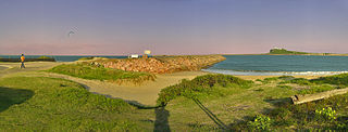
Stockton is a suburb of Newcastle, New South Wales, Australia, located 600 m (0.4 mi) from Newcastle's central business district. It is the only residential suburb of the City of Newcastle that lies north of the Hunter River.

RAAF Base Williamtown is a Royal Australian Air Force (RAAF) military air base located 8 nautical miles north of Newcastle in the local government area of Port Stephens, in New South Wales, Australia. The base serves as the headquarters to both the Air Combat Group and the Surveillance and Response Group of the RAAF. The military base shares its runway facilities with Newcastle Airport. The nearest towns are Raymond Terrace, located 8 km (5 mi) west of the base and Medowie, 6.8 km (4.2 mi), north of the base, which is home to many of the base's staff.
Medowie is a suburb of the Port Stephens local government area in the Hunter Region of New South Wales, Australia. It is located approximately 34 km (21 mi) by road north of Newcastle, not far from RAAF Base Williamtown and is home to many of the personnel stationed there. The Worimi people are the traditional owners of the Port Stephens area.

Salamander Bay is a suburb of the Port Stephens local government area in the Hunter Region of New South Wales, Australia. The Worimi people are the traditional owners of the Port Stephens area. Named after the adjacent shallow bay, itself named after Salamander, a convict ship from the Third Fleet, which was the first European vessel to enter Port Stephens (1791), it is a mainly residential suburb with a large shopping centre. At the 2021 census, Salamander Bay had a population of 4,991. It is home to Tomaree High School, a TAFE facility and St Phillips Christian College.
Nelson Bay is a significant township of the Port Stephens local government area in the Hunter Region of New South Wales, Australia. It is located on a bay of the same name on the southern shore of Port Stephens about 60 kilometres (37 mi) by road north-east of Newcastle, its nearest rail link. At the 2021 census, Nelson Bay had a population of 6,141.

Woodville is a rural suburb in the Hunter Region of New South Wales, Australia that is shared between the Port Stephens and Maitland local government areas (LGA). Most of the suburb lies to the east of the Paterson River in the Port Stephens LGA while a small area of approximately 1.3 square kilometres (0.5 sq mi), to the west of the Paterson, is within the boundaries of the Maitland LGA.

Bobs Farm is a sparsely populated rural suburb of the Port Stephens local government area in the Hunter Region of New South Wales, Australia. It is on the main road between Newcastle and Nelson Bay and is home to a number of small, boutique style vineyards and wineries and a thriving aquaculture industry. Bobs Farm Public School on Marsh Road is a co-educational government primary school which was established in 1918.

Williamtown is a rural suburb of the Port Stephens local government area in the Hunter Region of New South Wales, Australia. It is located on the main road between Newcastle and Nelson Bay.

Tomago is a combined industrial/semi-rural suburb of the Port Stephens local government area in the Hunter Region of New South Wales, Australia. It is located just north of the Hunter River and west of the body of water known as Fullerton Cove. Tomago means "sweet water" in the local Aboriginal language. In 2016 277 lived in Tomago with a median age of 55, 72.7% born in Australia and 80.4% only speaking English at home.

Fullerton Cove is a rural suburb of the Port Stephens local government area in the Hunter Region of New South Wales, Australia, located just north of Fern Bay and adjacent to Fullerton Cove, from which the suburb gets its name. The Worimi people are the traditional owners of the Port Stephens area. At the 2021 Australian census the population of Fullerton Cove was 745.

Tanilba Bay is a suburb of the Port Stephens local government area in the Hunter Region of New South Wales, Australia. It is located on the Tilligerry Peninsula adjacent to the bay from which it got its name. "Tanilba" is said to mean "place of white flowers" in a local Indigenous language, presumably a reference to the flannel flowers which formerly thrived in the area. At the 2021 census Tanilba Bay had a population of 3,237. Tanilba Bay Public School is a co-ed government primary school located at 1A King Albert Avenue.

Mallabula is a primarily residential suburb of the Port Stephens local government area in the Hunter Region of New South Wales, Australia. It is located on the Tilligerry Peninsula between Lemon Tree Passage and Tanilba Bay. The origin of the name may mean "three swamps" in the local Aboriginal language.
Duns Creek is a rural residential suburb in the Hunter Region of New South Wales, Australia, located near the historic village of Paterson in the north-western corner of the Port Stephens Council local government area.
Hinton is a suburb of the Port Stephens local government area in the Hunter Region of New South Wales, Australia. Primarily rural, the largest population centre is the township of Hinton, which is situated on the Paterson River, near to the confluence of the Hunter and Paterson rivers. In 1835 the post office requested a name for the town and the surveyor general suggested Hinton prior to this it was known as the second arm of the Hunter river. The first European settlers were 12 ex convicts in 1818.
Osterley is a small rural suburb of the Port Stephens local government area in the Hunter Region of New South Wales, Australia. Most of the small population lives in the elevated part of the suburb along Hinton Road, east of Barties Creek which is a tributary of the Hunter River. The area to the west of Barties creek is low-lying and subject to periodic flooding. .In 2016 117 people live there with a median age of 46.

Nelsons Plains is a primarily rural suburb of the Port Stephens local government area in the Hunter Region of New South Wales, Australia. It is situated on Seaham Road between the Hunter and Williams rivers. At the 2016 census the suburb had a population of 362.

East Seaham is a primarily rural suburb of the Port Stephens local government area in the Hunter Region of New South Wales, Australia. It is situated on the east bank of the Williams River, opposite Glen Oak and Seaham. At the 2011 census, the population of East Seaham and the adjacent suburb of Balickera was 359, with the two suburbs having an average population density of 5.5/km2 (14/sq mi).

Heatherbrae is a suburb of the Port Stephens local government area in the Hunter Region of New South Wales, Australia. The suburb lies to the east of the Hunter River and to the south of the town of Raymond Terrace. It is bisected by the Pacific Highway. At the 2016 census it had a population of 512. Most of the population lives to the west of the Pacific Highway in a housing subdivision while some residents live to the east of the highway in a semi-industrial area. Remaining residents live in rural and semi-rural areas adjacent to the highway and throughout the rest of the suburb. The Worimi people are the traditional owners of the Port Stephens area. In 2016 the median age of the population was 54. 80% were born in Australia, 2.6% New Zealand, 2.2% Pakistan, 2.0% England, 1% Germany and 0.8% China. In terms of religion, 26.1% were Anglican, 21.4% No Religion, 19.0% Catholic, 12.0% Not Stated and 4.5% Uniting Church. In terms of languages spoken other than English, 2.2% speak Urdu, 0.8% Tagalog, 0.6% Italian, 0.6% Serbo-Croatian/Yugoslavian and 0.6% Bengali.

Campvale is a sparsely populated rural suburb of the Port Stephens local government area in the Hunter Region of New South Wales, Australia.
Ferodale is a sparsely populated rural suburb of the Port Stephens local government area in the Hunter Region of New South Wales, Australia. A large portion of the suburb is occupied by Grahamstown Dam, the lower Hunter Region's main water storage reservoir.


