San Fernando | |
---|---|
Municipality of San Fernando | |
San Fernando Municipal Hall | |
Nickname: The Land of Heroic Waves | |
Motto: On the Go San Fernando | |
Anthem: San Fernando,Cebu hymn | |
![]() Map of Cebu with San Fernando highlighted | |
Location within the Philippines | |
Coordinates: 10°10′N123°42′E / 10.17°N 123.7°E | |
Country | Philippines |
Region | Central Visayas |
Province | Cebu |
District | 1st district |
Founded | 1858 |
Barangays | 21 (see Barangays) |
Government | |
• Type | Sangguniang Bayan |
• Mayor | Mytha Ann B. Canoy (NP) |
• Vice Mayor | Eugema V. Bacalla (NP) |
• Representative | Rhea Mae A. Gullas |
• Municipal Council | Members |
• Electorate | 51,416 voters (2025) |
Area | |
• Total | 69.39 km2 (26.79 sq mi) |
Elevation | 85 m (279 ft) |
Highest elevation | 401 m (1,316 ft) |
Lowest elevation | 0 m (0 ft) |
Population (2024 census) [3] | |
• Total | 76,110 |
• Density | 1,100/km2 (2,800/sq mi) |
• Households | 16,555 |
Economy | |
• Income class | 2nd municipal income class |
• Poverty incidence | 28.2 |
• Revenue | ₱ 244.9 million (2020) |
• Assets | ₱ 725.5 million (2020) |
• Expenditure | ₱ 257.5 million (2020) |
• Liabilities | ₱ 101.9 million (2020) |
Service provider | |
• Electricity | Visayan Electric Company (VECO) |
Time zone | UTC+8 (PST) |
ZIP code | 6018 |
PSGC | |
IDD : area code | +63 (0)32 |
Native languages | Cebuano Tagalog |
San Fernando, officially the Municipality of San Fernando (Cebuano : Lungsod sa San Fernando; Tagalog : Bayan ng San Fernando), is a municipality in the province of Cebu, Philippines. According to the 2024 census, it has a population of 76,110 people. [5]
The town was established in 1858 following the separation of the barrios of Magsico, Cabatbatan, Balungag, Sangat, Panadtaran, and Pitalo from Naga, with an initial population of nearly 3,000 people. The town was initially named San Isidro Labrador before changing to San Fernando in honor of a well-liked priest, Father Fernando Sanchez and his namesake saint. [6]
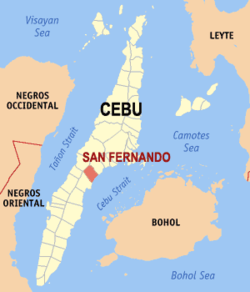
San Fernando is bordered to the north by the City of Naga, to the west is the town of Pinamungajan, to the east is the Cebu Strait, and to the south is the city of Carcar. It is 29 kilometres (18 mi) from Cebu City.
San Fernando lies within Metro Cebu. [7]
San Fernando is politically subdivided into 21 barangays. Each barangay consists of puroks and some have sitios.
PSGC | Barangay | Population | ±% p.a. | |||
---|---|---|---|---|---|---|
2024 [8] | 2010 [9] | |||||
072241002 | Balud | 5.4% | 4,135 | 3,525 | 1.12% | |
072241003 | Balungag | 2.8% | 2,116 | 1,855 | 0.93% | |
072241005 | Basak | 1.3% | 1,017 | 1,009 | 0.06% | |
072241007 | Bugho | 1.7% | 1,317 | 1,367 | −0.26% | |
072241008 | Cabatbatan | 2.5% | 1,933 | 1,875 | 0.21% | |
072241009 | Green Hills | 3.3% | 2,508 | 2,700 | −0.51% | |
072241024 | Ilaya | 2.6% | 1,975 | 1,918 | 0.21% | |
072241010 | Lantawan | 2.7% | 2,054 | 1,789 | 0.97% | |
072241011 | Liburon | 1.3% | 995 | 1,009 | −0.10% | |
072241012 | Magsico | 2.9% | 2,188 | 2,188 | 0.00% | |
072241014 | Panadtaran | 7.1% | 5,400 | 4,971 | 0.58% | |
072241015 | Pitalo | 10.5% | 7,962 | 7,311 | 0.60% | |
072241013 | Poblacion North | 5.8% | 4,444 | 4,205 | 0.39% | |
072241018 | Poblacion South | 10.9% | 8,294 | 7,352 | 0.85% | |
072241016 | San Isidro | 5.4% | 4,128 | 3,691 | 0.79% | |
072241017 | Sangat | 7.8% | 5,910 | 5,597 | 0.38% | |
072241019 | Tabionan | 2.8% | 2,147 | 1,873 | 0.96% | |
072241020 | Tananas | 2.2% | 1,706 | 1,345 | 1.68% | |
072241021 | Tinubdan | 2.9% | 2,215 | 1,994 | 0.74% | |
072241022 | Tonggo | 2.8% | 2,110 | 1,936 | 0.60% | |
072241023 | Tubod | 2.3% | 1,726 | 1,460 | 1.18% | |
Total | 76,110 | 60,970 | 1.56% |
Climate data for San Fernando, Cebu | |||||||||||||
---|---|---|---|---|---|---|---|---|---|---|---|---|---|
Month | Jan | Feb | Mar | Apr | May | Jun | Jul | Aug | Sep | Oct | Nov | Dec | Year |
Mean daily maximum °C (°F) | 28 (82) | 29 (84) | 30 (86) | 31 (88) | 31 (88) | 30 (86) | 30 (86) | 30 (86) | 30 (86) | 29 (84) | 29 (84) | 28 (82) | 30 (85) |
Mean daily minimum °C (°F) | 23 (73) | 23 (73) | 23 (73) | 24 (75) | 25 (77) | 25 (77) | 25 (77) | 25 (77) | 25 (77) | 25 (77) | 24 (75) | 23 (73) | 24 (75) |
Average precipitation mm (inches) | 70 (2.8) | 49 (1.9) | 62 (2.4) | 78 (3.1) | 138 (5.4) | 201 (7.9) | 192 (7.6) | 185 (7.3) | 192 (7.6) | 205 (8.1) | 156 (6.1) | 111 (4.4) | 1,639 (64.6) |
Average rainy days | 13.4 | 10.6 | 13.1 | 14.5 | 24.2 | 27.9 | 28.4 | 27.7 | 27.1 | 27.4 | 22.5 | 15.9 | 252.7 |
Source: Meteoblue [10] |
Year | Pop. | ±% p.a. |
---|---|---|
1903 | 15,451 | — |
1918 | 20,029 | +1.75% |
1939 | 17,562 | −0.62% |
1948 | 16,132 | −0.94% |
1960 | 19,061 | +1.40% |
1970 | 24,073 | +2.36% |
1975 | 25,877 | +1.46% |
1980 | 28,324 | +1.82% |
1990 | 35,051 | +2.15% |
1995 | 38,700 | +1.87% |
2000 | 48,235 | +4.83% |
2007 | 54,932 | +1.81% |
2010 | 60,970 | +3.87% |
2015 | 66,280 | +1.60% |
2020 | 72,224 | +1.82% |
2024 | 76,110 | +1.27% |
Source: Philippine Statistics Authority [11] [12] [9] [13] [14] |
San Fernando is home to the PHIVOLCS Visayas Cluster Monitoring Center for Earthquake and Tsunami located in Purok 11-Santan, Barangay North Poblacion. [15]
Poverty incidence of San Fernando
10 20 30 40 50 2000 45.30 2003 22.78 2006 31.00 2009 26.21 2012 20.65 2015 24.27 2018 15.00 2021 28.20 Source: Philippine Statistics Authority [16] [17] [18] [19] [20] [21] [22] [23] |
In July 2024, Secretary Alfredo Pascual and Mayor Mytha Ann B. Canoy graced Taiheiyo Cement Philippines, Inc.'s inauguration of a PHP12.8 billion (US$220) production line in San Fernando. It has a capacity of 3 Mt annually, or 6000 tons per day of cement clinker and features advanced cement kiln renewal technology. [24]
The public schools in the town of San Fernando are administered by one school district under the Schools Division of Cebu Province [ permanent dead link ].
Elementary schools:
High schools:
Integrated schools: