Daanbantayan

Last updated

Daanbantayan
Municipality of Daanbantayan
Maya Daanbantayan.jpg
Maya, Daanbantayan – northernmost point of Cebu island
DaanBantayanMunicipalitySeal.jpg
Ph locator cebu daanbantayan.png
Map of Cebu with Daanbantayan highlighted
OpenStreetMap
Daanbantayan
Philippines location map (square).svg
Red pog.svg
Daanbantayan
Location within the Philippines
Coordinates: 11°15′N124°00′E / 11.25°N 124°E / 11.25; 124
Country Philippines
Region Central Visayas
Province Cebu
District 4th district
Founded 1886
Barangays 20 (see Barangays)
Government
[1]
  Type Sangguniang Bayan
   Mayor Sun J. Shimura
   Vice Mayor Elver Ali B. Abucay
   Representative Janice Z. Salimbangon
   Municipal Council
Members
   Electorate 56,557 voters (2022)
Area
[2]
  Total92.27 km2 (35.63 sq mi)
Elevation
11 m (36 ft)
Highest elevation
120 m (390 ft)
Lowest elevation
0 m (0 ft)
Population
 (2020 census) [3]
  Total93,502
  Density1,000/km2 (2,600/sq mi)
   Households
22,289
Economy
   Income class 1st municipal income class
   Poverty incidence
17.80
% (2018) [4]
   Revenue 447.6 million (2020)
   Assets 979.6 million (2020)
   Expenditure 376.5 million (2020)
   Liabilities 329.4 million (2020)
Service provider
  ElectricityCebu 2 Electric Cooperative (CEBECO 2)
Time zone UTC+8 (PST)
ZIP code
6013
PSGC
IDD : area code +63(0)32
Native languages Cebuano
Tagalog

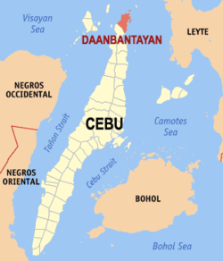
Daanbantayan, officially the Municipality of Daanbantayan (Cebuano : Lungsod sa Daanbantayan; Tagalog : Bayan ng Daanbantayan), is a 1st class municipality in the province of Cebu, Philippines. According to the 2020 census, it has a population of 93,502 people. [3]

Contents

Located at the northern tip of Cebu island, Daanbantayan celebrates its annual fiesta along with the Haladaya Festival which starts 21 August and ends with street-dancing on 30 August, in honor of Datu Daya, the legendary founder of the town.

Daanbantayan is bordered on the north by the Visayan Sea, to the west by Bantayan Island, on the east by the Camotes Sea, and on the south by the town of Medellin. It is 136 kilometres (85 mi) from Cebu City.

History

The name Daanbantayan was derived from two words: the word "daan", which means "old" in Cebuano, and the word "bantayan", which refers to a place that served as a look out for Moro raiders during the Pre-Hispanic Philippines. The original site of the town might have been at an elevated vantage point near Punta, in Tapilon.
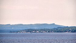
On 8 November 2013, 9 people were killed and 50 injured when Super Typhoon Haiyan (Yolanda in Philippines area of responsibility) passed over Daanbantayan. [5]

Geography

Islands and thalassic attractions

There are several small islands/islets and diving spots, with the list below arranged by latitude from nearest to farthest from Cebu island:

Barangays

Daanbantayan is politically subdivided into 20 barangays. Each barangay consists of puroks and some have sitios.

PSGC Barangay Population ±% p.a.
2020 [3] 2010 [6]
072221001 Aguho 6.1% 5,726 4,836 1.70%
072221002 Bagay 4.9% 4,549 4,015 1.26%
072221003 Bakhawan 2.7% 2,540 2,267 1.14%
072221004 Bateria 3.9% 3,664 3,252 1.20%
072221005 Bitoon 5.1% 4,753 4,350 0.89%
072221006 Calape 2.4% 2,233 2,518 −1.19%
072221007 Carnaza 2.4% 2,259 2,360 −0.44%
072221008 Dalingding 2.3% 2,137 2,069 0.32%
072221009 Lanao 3.5% 3,313 2,968 1.11%
072221010 Logon 6.1% 5,720 4,496 2.44%
072221011 Malbago 4.7% 4,408 3,311 2.90%
072221012 Malingin 1.7% 1,600 1,512 0.57%
072221013 Maya 9.4% 8,822 7,815 1.22%
072221014 Pajo 3.9% 3,634 2,970 2.04%
072221015 Paypay 3.1% 2,888 2,741 0.52%
072221016 Poblacion 8.3% 7,794 7,144 0.87%
072221017 Talisay 4.6% 4,297 3,802 1.23%
072221018 Tapilon 8.9% 8,323 7,281 1.35%
072221019 Tinubdan 2.1% 2,002 2,050 −0.24%
072221020 Tominjao 4.0% 3,768 3,149 1.81%
Total93,50274,8972.24%

Climate

Climate data for Daanbantayan, Cebu
MonthJanFebMarAprMayJunJulAugSepOctNovDecYear
Average high °C (°F)28
(82)
29
(84)
29
(84)
31
(88)
31
(88)
30
(86)
30
(86)
30
(86)
30
(86)
29
(84)
29
(84)
29
(84)
30
(85)
Average low °C (°F)22
(72)
22
(72)
22
(72)
23
(73)
24
(75)
25
(77)
25
(77)
25
(77)
25
(77)
24
(75)
24
(75)
23
(73)
24
(75)
Average precipitation mm (inches)73
(2.9)
56
(2.2)
75
(3.0)
71
(2.8)
114
(4.5)
174
(6.9)
172
(6.8)
163
(6.4)
167
(6.6)
161
(6.3)
158
(6.2)
125
(4.9)
1,509
(59.5)
Average rainy days15.212.516.217.323.927.328.426.926.927.123.819.3264.8
Source: Meteoblue (modeled/calculated data, not measured locally) [7]

Demographics

Population census of Daanbantayan
YearPop.±% p.a.
1903 14,735    
1918 21,334+2.50%
1939 24,198+0.60%
1948 29,484+2.22%
1960 34,599+1.34%
YearPop.±% p.a.
1970 40,649+1.62%
1975 43,228+1.24%
1980 45,926+1.22%
1990 58,771+2.50%
1995 64,845+1.86%
YearPop.±% p.a.
2000 69,336+1.45%
2007 73,254+0.76%
2010 74,897+0.81%
2015 84,430+2.31%
2020 93,502+2.03%
Source: Philippine Statistics Authority [8] [6] [9]

Economy

Transportation

Ceres Liner (And Sugbo Transit), White Stallion Express (Subsidiary Of Rough Riders) and Cebu Autobus are among the bus companies with regular service to and from Cebu city (North Bus Terminal). Jeepneys, tricycles, and trisikads are the main modes of transportation within the town.

Tourism

Daanbantayan is now known for its pristine, white powder-like sandy beaches – one of which is Malapascua Island. With its vast and rich marine resources, it hosts a long string of dive sites offering unique marine life and beauty.

As a tourist destination, Daanbantayan stages the Haladaya Festival every year as an added attraction to local vacationers, holidaymakers, Filipino expatriates, and foreign tourists from as far away as North America, South America, and Europe.

Attractions

Related Research Articles

<span class="mw-page-title-main">Alcoy, Cebu</span> Municipality in Cebu, Philippines

Alcoy, officially the Municipality of Alcoy, is a 5th class municipality in the province of Cebu, Philippines. According to the 2020 census, it has a population of 19,186 people.

<span class="mw-page-title-main">Bantayan, Cebu</span> Municipality in Cebu, Philippines

Bantayan, officially the Municipality of Bantayan, is a 1st class municipality in the province of Cebu, Philippines. According to the 2020 census, it has a population of 86,247 people, making it the island's most populous town as well as the largest.

<span class="mw-page-title-main">Alegria, Cebu</span> Municipality in Cebu, Philippines

Alegria, officially the Municipality of Alegria, is a 4th class municipality in the province of Cebu, Philippines. According to the 2020 census, it has a population of 25,620 people.

<span class="mw-page-title-main">Cordova, Cebu</span> Municipality in Cebu, Philippines

Cordova, officially the Municipality of Cordova, is a 3rd class municipality in the province of Cebu, Philippines. According to the 2020 census, it has a population of 70,595 people.

<span class="mw-page-title-main">Madridejos, Cebu</span> Municipality in Cebu, Philippines

Madridejos, officially the Municipality of Madridejos, is a 4th class municipality in the province of Cebu, Philippines. According to the 2020 census, it has a population of 42,039 people.

<span class="mw-page-title-main">Medellin, Cebu</span> Municipality in Cebu, Philippines

Medellin, officially the Municipality of Medellin, is a 2nd class municipality in the province of Cebu, Philippines. According to the 2020 census, it has a population of 59,605 people.

<span class="mw-page-title-main">Moalboal</span> Municipality in Cebu, Philippines

Moalboal, officially the Municipality of Moalboal, is a fourth class municipality in the province of Cebu, Philippines. According to the 2020 census, it has a population of 36,930.

<span class="mw-page-title-main">Pilar, Cebu</span> Municipality in Cebu, Philippines

Pilar, officially the Municipality of Pilar, is a 5th class municipality in the province of Cebu, Philippines. According to the 2020 census, it has a population of 12,506 people.

<span class="mw-page-title-main">Poro, Cebu</span> Municipality in Cebu, Philippines

Poro, officially the Municipality of Poro, is a 4th class municipality in the province of Cebu, Philippines. According to the 2020 census, it has a population of 26,232 people.

<span class="mw-page-title-main">San Fernando, Cebu</span> Municipality in Cebu, Philippines

San Fernando, officially the Municipality of San Fernando, is a second-class municipality in the province of Cebu, Philippines. According to the 2020 census, it has a population of 72,224 people.

<span class="mw-page-title-main">San Francisco, Cebu</span> Municipality in Cebu, Philippines

San Francisco, officially the Municipality of San Francisco, is a 3rd class municipality in the province of Cebu, Philippines. According to the 2020 census, it has a population of 59,236 people.

<span class="mw-page-title-main">San Remigio, Cebu</span> Municipality in Cebu, Philippines

San Remigio, officially called the Municipality of San Remigio, is a 3rd class municipality in the province of Cebu, Philippines. According to the 2020 census, it has a population of 65,744 people.

<span class="mw-page-title-main">Santa Fe, Cebu</span> Municipality in Cebu, Philippines

Santa Fe, officially the Municipality of Santa Fe, is a 5th class municipality in the province of Cebu, Philippines. According to the 2020 census, it has a population of 34,471 people.

<span class="mw-page-title-main">Tabuelan</span> Municipality in Cebu, Philippines

Tabuelan, officially the Municipality of Tabuelan, is a 4th class municipality in the province of Cebu, Philippines. According to the 2020 census, it has a population of 28,907 people.

<span class="mw-page-title-main">Tudela, Cebu</span> Municipality in Cebu, Philippines

Tudela, officially the Municipality of Tudela, is a 5th class municipality in the province of Cebu, Philippines. According to the 2020 census, it has a population of 11,304 people.

<span class="mw-page-title-main">Libacao</span> Municipality in Aklan, Philippines

Libacao, officially the Municipality of Libacao, is a 3rd class municipality in the province of Aklan, Philippines. According to the 2020 census, it has a population of 28,272 people.

<span class="mw-page-title-main">Siquijor, Siquijor</span> Capital of Siquijor, Philippines

Siquijor, officially the Municipality of Siquijor, is a 4th class municipality and capital of the province of Siquijor, Philippines. According to the 2020 census, it has a population of 28,915 people.

<span class="mw-page-title-main">Calape</span> Municipality in Bohol, Philippines

Calape, officially the Municipality of Calape, is a 3rd class municipality in the province of Bohol, Philippines. According to the 2020 census, it has a population of 33,079 people.

<span class="mw-page-title-main">Tubigon</span> Municipality in Bohol, Philippines

Tubigon, officially the Municipality of Tubigon, is a 1st class municipality in the province of Bohol, Philippines. According to the 2020 census, it has a population of 47,886 people.

<span class="mw-page-title-main">Malapascua</span> Island in the Philippines

Malapascua is a Philippine island situated in the Visayan Sea, 6.8 kilometres (4.2 mi) across a shallow strait from the northernmost tip of Cebu Island. Administratively, it is part of the peninsular barangay of Logon, Daanbantayan, Cebu. Malapascua is a small island, only about 2.5 by 1 kilometre, and has eight hamlets. According to the latest 2020 census, the island has an estimated population of 6,257.

References

  1. Municipality of Daanbantayan | (DILG)
  2. "2015 Census of Population, Report No. 3 – Population, Land Area, and Population Density" (PDF). Philippine Statistics Authority. Quezon City, Philippines. August 2016. ISSN   0117-1453. Archived (PDF) from the original on 25 May 2021. Retrieved 16 July 2021.
  3. 1 2 3 Census of Population (2020). "Region VII (Central Visayas)". Total Population by Province, City, Municipality and Barangay. Philippine Statistics Authority . Retrieved 8 July 2021.
  4. "PSA Releases the 2018 Municipal and City Level Poverty Estimates". Philippine Statistics Authority. 15 December 2021.
  5. The Economist (16 November 2013). "Typhoon Haiyan Damage Is 'Worse Than Hell'". Business Insider Australia. Archived from the original on 18 November 2013.
  6. 1 2 Census of Population and Housing (2010). "Region VII (Central Visayas)". Total Population by Province, City, Municipality and Barangay. National Statistics Office . Retrieved 29 June 2016.
  7. "Bantayan: Average Temperatures and Rainfall". Meteoblue. Retrieved 10 May 2020.
  8. Census of Population (2015). "Region VII (Central Visayas)". Total Population by Province, City, Municipality and Barangay. Philippine Statistics Authority . Retrieved 20 June 2016.
  9. Censuses of Population (1903–2007). "Region VII (Central Visayas)". Table 1. Population Enumerated in Various Censuses by Province/Highly Urbanized City: 1903 to 2007. National Statistics Office.
  10. "Poverty incidence (PI):". Philippine Statistics Authority.
  11. "Estimation of Local Poverty in the Philippines" (PDF). Philippine Statistics Authority. 29 November 2005.
  12. "2003 City and Municipal Level Poverty Estimates" (PDF). Philippine Statistics Authority. 23 March 2009.
  13. "City and Municipal Level Poverty Estimates; 2006 and 2009" (PDF). Philippine Statistics Authority. 3 August 2012.
  14. "City and Municipal Level Poverty Estimates; 2006 and 2009" (PDF). Philippine Statistics Authority. 3 August 2012.
  15. "Municipal and City Level Poverty Estimates; 2012" (PDF). Philippine Statistics Authority. 31 May 2016.
  16. "Municipal and City Level Small Area Poverty Estimates; 2009, 2012 and 2015". Philippine Statistics Authority. 10 July 2019.
  17. "PSA Releases the 2018 Municipal and City Level Poverty Estimates". Philippine Statistics Authority. 15 December 2021.
  18. 1 2 3 4 5 6 "Local Heritage". Municipality of Daanbantayan, Cebu. Archived from the original on 8 March 2016. Retrieved 5 April 2013.