San Francisco | |
---|---|
Municipality of San Francisco | |
Location within the Philippines | |
Coordinates: 10°39′N124°21′E / 10.65°N 124.35°E | |
Country | Philippines |
Region | Central Visayas |
Province | Cebu |
District | 5th district |
Named for | St. Francis of Assisi |
Barangays | 15 (see Barangays) |
Government | |
• Type | Sangguniang Bayan |
• Mayor | Alfredo A. Arquillano Jr. |
• Vice Mayor | Aly A. Arquillano |
• Representative | Vincent Franco D. Frasco |
• Municipal Council | Members |
• Electorate | 34,966 voters (2022) |
Area | |
• Total | 106.93 km2 (41.29 sq mi) |
Elevation | 29 m (95 ft) |
Highest elevation | 774 m (2,539 ft) |
Lowest elevation | 0 m (0 ft) |
Population (2020 census) [3] | |
• Total | 59,236 |
• Density | 550/km2 (1,400/sq mi) |
• Households | 13,957 |
Economy | |
• Income class | 3rd municipal income class |
• Poverty incidence | 54.32 |
• Revenue | ₱ 183.8 million (2020) |
• Assets | ₱ 492.8 million (2020) |
• Expenditure | ₱ 166.7 million (2020) |
• Liabilities | ₱ 227.2 million (2020) |
Service provider | |
• Electricity | Camotes Electric Cooperative (CELCO) |
Time zone | UTC+8 (PST) |
ZIP code | 6050 |
PSGC | |
IDD : area code | +63 (0)32 |
Native languages | Forohanon Cebuano Tagalog |
Website | sanfranciscocamotes |
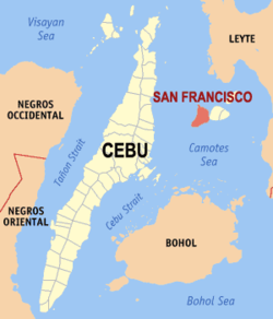
San Francisco, officially the Municipality of San Francisco (Cebuano : Lungsod sa San Francisco; Tagalog : Bayan ng San Francisco), is a 3rd class municipality in the province of Cebu, Philippines. According to the 2020 census, it has a population of 59,236 people. [3]
It is one of the municipalities that comprise the Camotes Islands.
San Francisco is bordered to the north by the Province of Leyte in the Camotes Sea, to the west is the Camotes Sea Facing Catmon, to the east is the island of Poro with town of Poro and to the south is the Camotes Sea.
Carl Guthe, director of the University of Michigan Anthropological Museum, during his 1923-25 collecting trip and explorations of archaeological sites in the Philippines, [5] conducted an archeological dig in a cave site on Tulang. Located on the southeastern coast of the island, the cave measures about 3.7 by 2.7 metres (12 by 9 feet). Guthe reported it to contain bone fragments and teeth of about 60 individuals. Associated grave goods included earthenware pottery, shell bracelets, bronze and iron artefacts (iron tang, bronze chisel, iron blade), glass and stone beads, hammerstone and pestle. Filed teeth were also recovered from this site. [lower-alpha 1]
Just before Typhoon Yolanda struck in November 2013, the mayor of San Francisco ordered the evacuation of all the residents (approximately 1,000) to the main island. This was credited with saving their lives as all houses on the island (about 500) were completely destroyed. [6]
San Francisco consists primarily of Pacijan (also known as Pajican [7] ) and Tulang (area less than 1 square kilometre (0.39 sq mi), just north of Pacijan) islands, which are part of the Camotes Islands (which also include Poro and Ponson islands). They are located east of the main island of Cebu, south and west of Leyte and north of Bohol.
Pacijan Island is about 14.75 kilometres (9.17 mi) long and 8.5 kilometres (5.3 mi) wide. A 1,400-metre (1,530 yd) causeway crosses the mangrove swamp to connect Pacijan and Poro islands. It was constructed during the Spanish era, to bridge the islands for easier trading and attending services in Poro church.[ citation needed ]
Tulang island (known locally as Tulang Diot) is a five-minute boat ride from Tulang Dako on the main island of Pacijan. Both Tulang Diot and Tulang Dako are part of Esperanza barangay. The islet is almost entirely covered with coconut palms and measures about 1.6 by 0.6 kilometres (1.0 by 0.4 mi): the residential area is confined to a small triangle at the southern end. Total area is less than 1 km2 (0.39 sq mi) or 40 ha (100 acres), of which only 3.5 ha (8.6 acres) (8.8%) is inhabited.[ citation needed ]
San Francisco is politically subdivided into 15 barangays. Each barangay consists of puroks and some have sitios.
PSGC | Barangay | Population | ±% p.a. | |||
---|---|---|---|---|---|---|
2020 [3] | 2010 [8] | |||||
0702242002 | Cabunga‑an | 3.8% | 2,226 | 1,764 | 2.35% | |
0702242003 | Campo | 5.3% | 3,123 | 2,517 | 2.18% | |
0702242004 | Consuelo | 9.7% | 5,750 | 4,827 | 1.76% | |
0702242006 | Esperanza | 10.8% | 6,370 | 5,629 | 1.24% | |
0702242007 | Himensulan | 3.9% | 2,331 | 2,169 | 0.72% | |
0702242001 | Montealegre | 2.9% | 1,735 | 1,288 | 3.02% | |
0702242008 | Northern Poblacion | 8.1% | 4,786 | 3,779 | 2.39% | |
0702242009 | San Isidro | 7.3% | 4,346 | 3,668 | 1.71% | |
0702242010 | Santa Cruz | 9.2% | 5,465 | 4,717 | 1.48% | |
0702242011 | Santiago | 4.1% | 2,412 | 2,132 | 1.24% | |
0702242012 | Sonog | 6.4% | 3,799 | 3,366 | 1.22% | |
0702242013 | Southern Poblacion | 7.0% | 4,143 | 3,453 | 1.84% | |
0702242014 | Unidos | 1.7% | 992 | 1,035 | −0.42% | |
0702242015 | Union | 8.5% | 5,023 | 4,721 | 0.62% | |
0702242016 | Western Poblacion | 4.5% | 2,679 | 2,292 | 1.57% | |
Total | 59,236 | 47,357 | 2.26% |
Climate data for San Francisco, Cebu | |||||||||||||
---|---|---|---|---|---|---|---|---|---|---|---|---|---|
Month | Jan | Feb | Mar | Apr | May | Jun | Jul | Aug | Sep | Oct | Nov | Dec | Year |
Mean daily maximum °C (°F) | 28 (82) | 29 (84) | 29 (84) | 30 (86) | 30 (86) | 30 (86) | 29 (84) | 29 (84) | 29 (84) | 29 (84) | 29 (84) | 29 (84) | 29 (84) |
Mean daily minimum °C (°F) | 22 (72) | 22 (72) | 22 (72) | 23 (73) | 25 (77) | 25 (77) | 25 (77) | 25 (77) | 25 (77) | 24 (75) | 24 (75) | 23 (73) | 24 (75) |
Average precipitation mm (inches) | 78 (3.1) | 57 (2.2) | 84 (3.3) | 79 (3.1) | 118 (4.6) | 181 (7.1) | 178 (7.0) | 169 (6.7) | 172 (6.8) | 180 (7.1) | 174 (6.9) | 128 (5.0) | 1,598 (62.9) |
Average rainy days | 16.7 | 13.8 | 17.3 | 18.5 | 23.2 | 26.5 | 27.1 | 26.0 | 26.4 | 27.5 | 24.6 | 21.0 | 268.6 |
Source: Meteoblue [9] |
Year | Pop. | ±% p.a. |
---|---|---|
1903 | 8,110 | — |
1918 | 10,772 | +1.91% |
1939 | 16,980 | +2.19% |
1948 | 19,286 | +1.42% |
1960 | 20,894 | +0.67% |
1970 | 23,028 | +0.98% |
1975 | 27,766 | +3.82% |
1980 | 28,806 | +0.74% |
1990 | 36,521 | +2.40% |
1995 | 39,115 | +1.29% |
2000 | 41,327 | +1.19% |
2007 | 44,588 | +1.05% |
2010 | 47,357 | +2.22% |
2015 | 55,180 | +2.95% |
2020 | 59,236 | +1.40% |
Source: Philippine Statistics Authority [10] [8] [11] |
The town is home to the Porohanon language, one of the most endangered languages in the Visayas. The language is only used in the Poro islands. The language is classified as distinct from Sebwano (Bisaya) by the Komisyon ng Wikang Filipino and is vital to the culture and arts of the Porohanon people.
Poverty incidence of San Francisco
10 20 30 40 50 60 70 2006 60.70 2009 59.49 2012 49.34 2015 44.13 2018 31.70 2021 54.32 Source: Philippine Statistics Authority [12] [13] [14] [15] [16] [17] [18] [19] |
Lapu-Lapu City, officially the City of Lapu-Lapu, is a 1st class highly urbanized city in the Central Visayas region of the Philippines. According to the 2020 census, it has a population of 497,604.
Catmon, officially the Municipality of Catmon, is a 4th class municipality in the province of Cebu, Philippines. According to the 2020 census, it has a population of 33,745 people.
The Camotes Islands are a group of islands in the Camotes Sea, Philippines. Combined area is 236.36 square kilometres (91.26 sq mi). The island group is located east of Cebu Island, southwest of Leyte Island, and north of Bohol Island. It is 34 nautical miles from Cebu City and is part of Cebu. According to the 2020 census, it has a population of 109,278. Population has grown 42.5% since 1990, equivalent to an annual growth rate of 1.19%.
Argao, officially the Municipality of Argao, is a 1st class municipality in the province of Cebu, Philippines. According to the 2020 census, it has a population of 78,187 people.
Asturias, officially the Municipality of Asturias, is a 3rd class municipality in the province of Cebu, Philippines. According to the 2020 census, it has a population of 55,397 people.
Compostela, officially the Municipality of Compostela, is a 3rd class municipality in the province of Cebu, Philippines. According to the 2020 census, it has a population of 55,874 people.
Cordova, officially the Municipality of Cordova, is a 1st class municipality in the province of Cebu, Philippines. According to the 2020 census, it has a population of 70,595 people.
Malabuyoc, officially the Municipality of Malabuyoc, is a 4th class municipality in the province of Cebu, Philippines. According to the 2020 census, it has a population of 19,770 people.
Medellin, officially the Municipality of Medellin, is a 1st class municipality in the province of Cebu, Philippines. According to the 2020 census, it has a population of 59,605 people.
Pilar, officially the Municipality of Pilar, is a 5th class municipality in the province of Cebu, Philippines. According to the 2020 census, it has a population of 12,506 people.
Poro, officially the Municipality of Poro, is a 4th class municipality in the province of Cebu, Philippines. According to the 2020 census, it has a population of 26,232 people.
Santa Fe, officially the Municipality of Santa Fe, is a 4th class municipality in the province of Cebu, Philippines. According to the 2020 census, it has a population of 34,471 people.
Tabogon, officially the Municipality of Tabogon, is a 3rd class municipality in the province of Cebu, Philippines. According to the 2020 census, it has a population of 41,432 people.
Tudela, officially the Municipality of Tudela, is a 5th class municipality in the province of Cebu, Philippines. According to the 2020 census, it has a population of 11,304 people, making it the least populated municipality in the province.
Calape, officially the Municipality of Calape, is a 3rd class municipality in the province of Bohol, Philippines. According to the 2020 census, it has a population of 33,079 people.
Getafe, officially the Municipality of Getafe and also spelled as Jetafe, is a 3rd class municipality in the province of Bohol, Philippines. According to the 2020 census, it has a population of 33,422 people.
Limasawa, officially the Municipality of Limasawa, is an island municipality in the province of Southern Leyte, Philippines. According to the 2020 census, it has a population of 6,191 people, making it the least populated town in the province.
Isabel, officially the Municipality of Isabel, is a 1st class municipality in the province of Leyte, Philippines. According to the 2020 census, it has a population of 46,781 people.
Poro Island is an island in the province of Cebu, located east of Cebu Island and west of Leyte Island. Two municipalities, Poro and Tudela, are located on Poro Island. It is one of the four Camotes Islands along with Pacijan Island, Ponson Island, and Tulang Island. The island is one of the early Pacific contact sites between the East and the West.
Central Visayas is an administrative region in the Philippines, numerically designated as Region VII. It consists of two provinces: Cebu and Bohol. The region also has three highly urbanized cities: Cebu City, Lapu-Lapu, and Mandaue.
{{cite encyclopedia}}
: CS1 maint: numeric names: authors list (link){{cite web}}
: CS1 maint: unfit URL (link)