San Pascual | |
---|---|
Municipality of San Pascual | |
Motto(s): "San Pascual, Bayan Nating Mahal" "San Pascual, Bayang Marangal" | |
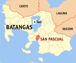
Location within the Philippines | |
Coordinates: 13°48′N121°02′E / 13.8°N 121.03°E | |
Country | Philippines |
Region | Calabarzon |
Province | Batangas |
District | 2nd district |
Founded | August 4, 1969 |
Named for | St. Paschal Baylón |
Barangays | 29 (see Barangays) |
Government | |
• Type | Sangguniang Bayan |
• Mayor | Antonio A. Dimayuga |
• Vice Mayor | Angelina D. Castillo |
• Representative | Gerville Luistro |
• Municipal Council | Members |
• Electorate | 41,762 voters (2022) |
Area | |
• Total | 50.70 km2 (19.58 sq mi) |
Elevation | 46 m (151 ft) |
Highest elevation | 155 m (509 ft) |
Lowest elevation | 0 m (0 ft) |
Population (2020 census) [3] | |
• Total | 69,009 |
• Density | 1,400/km2 (3,500/sq mi) |
• Households | 17,717 |
Economy | |
• Income class | 1st municipal income class |
• Poverty incidence | 11.37 |
• Revenue | ₱ 308.9 million (2020) |
• Assets | ₱ 863.9 million (2020) |
• Expenditure | ₱ 238.2 million (2020) |
• Liabilities | ₱ 85.09 million (2020) |
Service provider | |
• Electricity | Manila Electric Company (Meralco) |
Time zone | UTC+8 (PST) |
ZIP code | 4204 |
PSGC | |
IDD : area code | +63 (0)43 |
Native languages | Tagalog |
Major religions | Christianity |
Patron saint | St. Paschal Baylón |
San Pascual, officially the Municipality of San Pascual (Tagalog : Bayan ng San Pascual), is a 1st class municipality in the province of Batangas, Philippines. According to the 2020 census, it has a population of 69,009 making it as the 9th most populous municipality in the province.
The municipality borders Bauan on the west, Alitagtag and San Jose on the north, and Batangas City on the east.
Historically, San Pascual was a part of Bauan and was originally referred to as "Lagnas." The name "Lagnas", which refers to the municipality's location physically between the Lagnas and Hagonoy Rivers, is derived from the local dialect and means "river boundaries."
San Pascual became a separate municipality in 1969 by virtue of Republic Act No. 6116. It initially consisted of 25 barrios, all carved out from Bauan, namely: San Pascual, Danglayan, San Antonio, Laurel, Bayanan, San Mateo, Banaba, Natunuan North, Natunuan South, Kaing-in, Santo Niño, Sambat, Palsahingin, Alalum, Santa Elena, Del Pilar, Malaking Pook, Pila, San Mariano, Pook ni Banal, Pook ng Kapitan, Mataas na Lupa, Ilat, Gelerang Cawayan (Gelerang Kawayan), and Resplando. [5]
The religious populace and congregation therefore changed the name of the Lagnas neighborhood to San Pascual De Baylon in honor of the Roman Catholic saint. It was thought that naming a location after one of its patron saints would bring luck and a prosperous future. As a result, somewhere around 1959, the San Pascual neighborhood became the Parish of San Pascual de Baylon, with the aforementioned saint serving as its Patron Saint.
The municipal mayor is in charge of the municipality and serves as the head of the local government. The vice mayor serves as the mayor's deputy. Regarding the local legislature. The Sangguniang Bayan serves as the municipality's local legislature. The vice mayor serves as its president, and the council is made up of eight "councillors."
San Pascual is part of Batangas's 2nd congressional district. Gerville Luistro (Lakas-CMD) is the current representative of the 2nd district.
San Pascual is located at 13°48′N121°02′E / 13.8°N 121.03°E .
According to the Philippine Statistics Authority, the municipality has a land area of 50.70 square kilometers (19.58 sq mi) [6] constituting 1.63% of the 3,119.75-square-kilometer (1,204.54 sq mi) total area of Batangas.
San Pascual is 5 kilometers (3.1 mi) from Batangas City and 110 kilometers (68 mi) from Manila.
San Pascual is politically subdivided into 29 barangays. [7] Each barangay consists of puroks and some have sitios.
PSGC | Barangay | Population | ±% p.a. | |||
---|---|---|---|---|---|---|
2020 [3] | 2010 [8] | |||||
041026001 | Alalum | 3.1% | 2,155 | 1,986 | 0.82% | |
041026002 | Antipolo | 1.7% | 1,176 | 1,106 | 0.62% | |
041026003 | Balimbing | 2.4% | 1,648 | 522 | 12.18% | |
041026004 | Banaba | 3.9% | 2,662 | 2,440 | 0.87% | |
041026005 | Bayanan | 4.3% | 2,939 | 2,721 | 0.77% | |
041026006 | Danglayan | 1.2% | 841 | 580 | 3.78% | |
041026007 | Del Pilar | 1.1% | 759 | 667 | 1.30% | |
041026008 | Gelerang Kawayan | 2.2% | 1,533 | 1,519 | 0.09% | |
041026009 | Ilat North | 2.2% | 1,544 | 1,416 | 0.87% | |
041026010 | Ilat South | 2.0% | 1,363 | 1,385 | −0.16% | |
041026011 | Kaingin | 1.6% | 1,130 | 1,022 | 1.01% | |
041026012 | Laurel | 3.1% | 2,108 | 2,045 | 0.30% | |
041026013 | Malaking Pook | 1.1% | 780 | 756 | 0.31% | |
041026014 | Mataas na Lupa | 3.0% | 2,092 | 1,938 | 0.77% | |
041026015 | Natunuan North | 2.3% | 1,557 | 1,474 | 0.55% | |
041026016 | Natunuan South | 1.7% | 1,198 | 1,053 | 1.30% | |
041026017 | Padre Castillo | 1.7% | 1,189 | 960 | 2.16% | |
041026018 | Palsahingin | 1.5% | 1,065 | 980 | 0.84% | |
041026019 | Pila | 1.3% | 928 | 880 | 0.53% | |
041026020 | Poblacion | 14.8% | 10,188 | 9,977 | 0.21% | |
041026021 | Pook ni Banal | 2.0% | 1,347 | 1,223 | 0.97% | |
041026022 | Pook ni Kapitan | 1.3% | 927 | 752 | 2.11% | |
041026023 | Resplandor | 1.7% | 1,148 | 1,058 | 0.82% | |
041026024 | Sambat | 9.0% | 6,213 | 5,633 | 0.98% | |
041026025 | San Antonio | 13.2% | 9,096 | 8,639 | 0.52% | |
041026026 | San Mariano | 3.4% | 2,336 | 2,154 | 0.81% | |
041026027 | San Mateo | 2.4% | 1,651 | 1,201 | 3.23% | |
041026028 | Santa Elena | 0.9% | 650 | 595 | 0.89% | |
041026029 | Santo Niño | 4.6% | 3,201 | 2,916 | 0.94% | |
Total | 69,009 | 59,598 | 1.48% |
Climate data for San Pascual, Batangas | |||||||||||||
---|---|---|---|---|---|---|---|---|---|---|---|---|---|
Month | Jan | Feb | Mar | Apr | May | Jun | Jul | Aug | Sep | Oct | Nov | Dec | Year |
Mean daily maximum °C (°F) | 28 (82) | 29 (84) | 31 (88) | 32 (90) | 31 (88) | 30 (86) | 29 (84) | 28 (82) | 28 (82) | 29 (84) | 29 (84) | 28 (82) | 29 (85) |
Mean daily minimum °C (°F) | 19 (66) | 19 (66) | 20 (68) | 22 (72) | 24 (75) | 24 (75) | 24 (75) | 24 (75) | 24 (75) | 23 (73) | 21 (70) | 20 (68) | 22 (72) |
Average precipitation mm (inches) | 11 (0.4) | 13 (0.5) | 14 (0.6) | 32 (1.3) | 101 (4.0) | 142 (5.6) | 208 (8.2) | 187 (7.4) | 175 (6.9) | 131 (5.2) | 68 (2.7) | 39 (1.5) | 1,121 (44.3) |
Average rainy days | 5.2 | 5.0 | 7.4 | 11.5 | 19.8 | 23.5 | 27.0 | 25.9 | 25.2 | 23.2 | 15.5 | 8.3 | 197.5 |
Source: Meteoblue [9] |
Year | Pop. | ±% p.a. |
---|---|---|
1970 | 19,377 | — |
1975 | 21,761 | +2.35% |
1980 | 26,221 | +3.80% |
1990 | 34,629 | +2.82% |
1995 | 40,849 | +3.14% |
2000 | 49,041 | +4.00% |
2007 | 57,200 | +2.15% |
2010 | 59,598 | +1.51% |
2015 | 65,424 | +1.79% |
2020 | 69,009 | +1.05% |
Source: Philippine Statistics Authority [10] [8] [11] [12] |
In the 2020 census, San Pascual had a population of 69,009. [3] The population density was 1,400 inhabitants per square kilometre (3,600/sq mi).
Poverty incidence of San Pascual
2.5 5 7.5 10 12.5 15 2006 8.50 2009 5.76 2012 2.99 2015 2.76 2018 7.53 2021 11.37 Source: Philippine Statistics Authority [13] [14] [15] [16] [17] [18] [19] [20] |
As one of the towns adjacent to the province's capital, it is a bustling town full of businesses and establishments.
The town is home to an oil refinery, chemical plants and various subdivisions and housing projects, as well as other industrial and commercial establishments.
There are numerous elementary and high schools, offering primary and secondary education in the town of San Pascual. The most known high school in the municipality is the San Pascual National High School.
Batangas City, officially the City of Batangas, is a 1st class component city and capital of the province of Batangas, Philippines. According to the 2020 census, it has a population of 351,437 people.
Mabini, officially the Municipality of Mabini, is a 1st class municipality in the province of Batangas, Philippines. According to the 2020 census, it has a population of 50,858 people.
Alaminos, officially the Municipality of Alaminos, is a 3rd class municipality in the province of Laguna, Philippines. According to the 2020 census, it has a population of 51,619 people.
San Jose, officially the Municipality of San Jose, is a 1st class municipality in the province of Batangas, Philippines. According to the 2020 census, it has a population of 79,868 people.
Agoncillo, officially the Municipality of Agoncillo, is a 4th class municipality in the province of Batangas, Philippines. According to the 2020 census, it has a population of 39,101 people.
Alitagtag, officially the Municipality of Alitagtag, is a 4th class municipality in the province of Batangas, Philippines. According to the 2020 census, it has a population of 26,819 people.
Balete, officially the Municipality of Balete, is a 5th class municipality in the province of Batangas, Philippines. According to the 2020 census, it has a population of 24,055 people. The people from Balete is called Baleteños.
Bauan, officially the Municipality of Bauan, is a 1st class municipality in the province of Batangas, Philippines. According to the 2020 census, it has a population of 90,819 people.
Calaca, officially the City of Calaca, is a component city in the province of Batangas, Philippines. According to the 2020 census, it has a population of 87,361 people.
Cuenca, officially the Municipality of Cuenca, is a 4th class municipality in the province of Batangas, Philippines. According to the 2020 census, it has a population of 36,235 people.
Laurel, officially the Municipality of Laurel, is a 3rd class municipality in the province of Batangas, Philippines. According to the 2020 census, it has a population of 43,210 people.
Lian, officially the Municipality of Lian, is a 3rd class municipality in the province of Batangas, Philippines. According to the 2020 census, it has a population of 56,280 people.
Malvar, officially the Municipality of Malvar, is a 2nd class municipality in the province of Batangas, Philippines.
San Juan, officially the Municipality of San Juan, is a 1st class municipality in the province of Batangas, Philippines. According to the 2020 census, it has a population of 114,068 people.
San Luis, officially the Municipality of San Luis, is a 4th class municipality in the province of Batangas, Philippines. According to the 2020 census, it has a population of 36,172 people.
San Nicolas, officially the Municipality of San Nicolas, is a 5th class municipality in the province of Batangas, Philippines. According to the 2020 census, it has a population of 23,908 people. It is equivalent to 0.15% of the population in the Calabarzon area or 0.82% of the total population of Batangas province. These numbers are used to calculate the population density, which is 1,057 inhabitants per square kilometer or 2,740 inhabitants per square mile. The municipality makes up 0.73% of Batangas's total area, with a land area of 22.61 square kilometers or 8.73 square miles.
Santa Teresita, officially the Municipality of Santa Teresita, is a 5th class municipality in the province of Batangas, Philippines. According to the 2020 census, it has a population of 21,559 people.
Sto.Tomas, officially the City of Sto.Tomas, is a 1st class component city in the province of Batangas, Philippines. According to the 2020 census, it has a population of 218,500 people.
Taysan, officially the Municipality of Taysan, is a 2nd class municipality in the province of Batangas, Philippines. According to the 2020 census, it has a population of 40,146 people.
Tingloy, officially the Municipality of Tingloy, is a 5th class municipality in the province of Batangas, Philippines. According to the 2020 census, it has a population of 19,215 people, making it the least populated municipality in the province.
{{cite web}}
: CS1 maint: year (link){{cite encyclopedia}}
: CS1 maint: numeric names: authors list (link)