Related Research Articles

Hudson Strait links the Atlantic Ocean and Labrador Sea to Hudson Bay in Canada. This strait lies between Baffin Island and Nunavik, with its eastern entrance marked by Cape Chidley in Newfoundland and Labrador and Resolution Island off Baffin Island. The strait is about 750 km long with an average width of 125 km, varying from 70 km at the eastern entrance to 240 km at Deception Bay.

The Arctic Archipelago, also known as the Canadian Arctic Archipelago, is an archipelago lying to the north of the Canadian continental mainland, excluding Greenland.
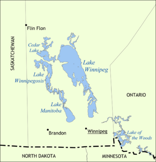
Lake Winnipeg is a very large, relatively shallow 24,514-square-kilometre (9,465 sq mi) lake in North America, in the province of Manitoba, Canada. Its southern end is about 55 kilometres (34 mi) north of the city of Winnipeg. Lake Winnipeg is Canada's sixth-largest freshwater lake and the third-largest freshwater lake contained entirely within Canada, but it is relatively shallow excluding a narrow 36 m (118 ft) deep channel between the northern and southern basins. It is the eleventh-largest freshwater lake on Earth. The lake's east side has pristine boreal forests and rivers that were in 2018 inscribed as Pimachiowin Aki, a UNESCO World Heritage Site. The lake is 416 km (258 mi) from north to south, with remote sandy beaches, large limestone cliffs, and many bat caves in some areas. Manitoba Hydro uses the lake as one of the largest reservoirs in the world. There are many islands, most of them undeveloped.

Fort Rouge is a provincial electoral division in the Canadian province of Manitoba. It was created by redistribution in 1957, and formally came into existence in the general election of 1958. The riding was eliminated in 1989, and re-established in 1999. It is located in the central section of the City of Winnipeg.

St. James is a provincial electoral division in the Canadian province of Manitoba.

Charleswood was a provincial electoral division in the Canadian province of Manitoba. It was created by redistribution in 1968, and formally existed from the provincial election of 1969 until that of 2019. The riding was in the westernmost tip of Manitoba's capital and largest city, Winnipeg.
River Heights is a provincial electoral division in the Canadian province of Manitoba. It was created by redistribution in 1957, and formally came into existence in the 1958 provincial election. The riding is located in the south-central region of the City of Winnipeg.
Fort Whyte is a provincial electoral division in the Canadian province of Manitoba. It was created in 1999, after the provincial electoral boundaries commission determined that southwestern Winnipeg had experienced enough population growth to deserve an extra seat. Fort Whyte was created from territory formerly belonging to Tuxedo, Fort Garry and St. Norbert.

Northern Manitoba is a geographic and cultural region of the Canadian province of Manitoba. Originally encompassing a small square around the Red River Colony, the province was extended north to the 60th parallel in 1912. The region's specific boundaries vary, as "northern" communities are considered to share certain social and geographic characteristics, regardless of latitude.
Reinfeld is an Unincorporated Urban Community (UUC) in the Rural Municipality of Stanley in the Pembina Valley region of Manitoba, Canada, about one km east of Winkler. Mainly a Mennonite community, its relative vicinity to Winkler makes it a possible candidate to become a suburb in the future.

The Interlake Region is an informal geographic region of the Canadian province of Manitoba that lies roughly between Lake Winnipeg and Lake Manitoba in the Canadian province of Manitoba. The region comprises 14 rural municipalities, one city, six towns and one village, Dunnottar. The largest population centre in the region is Selkirk. The second largest is the town of Stonewall.
Bowsman is an unincorporated urban community in the Municipality of Minitonas – Bowsman, Manitoba, Canada.
Fort Rouge was a fort located on the Assiniboine River in Manitoba, Canada, on the site of what is now the city of Winnipeg. Its exact location is unknown. Its name in English means "red fort".

The Council of Keewatin was an unelected legislative body and territorial government for the now defunct District of Keewatin in Canada. The District of Keewatin was created by the passage of the Keewatin Act on October 7, 1876 from a portion of Canada's North West Territories. Lieutenant Governor Alexander Morris convinced the government that the new territorial government of the North West Territories would be unable to effectively administer land to the north and east of Manitoba. Shortly after the District of Keewatin was formed a large group of Icelanders arrived, infected with smallpox which quickly spread to the indigenous First Nation population. The Government of Canada allowed the Council to be formed for the purpose of containing the smallpox epidemic. The Council also administered Indian treaty claims, immigrant land claims, Hudson's Bay Company trading post concerns as well as policing and health care. The Council lasted from November 25, 1876, until April 16, 1877, after which control of the territory was returned under federal authority.
Sandy Islands is a group of four islands located in the northern basin on Lake Winnipeg in the Canadian province of Manitoba. The Sandy Islands together with Little George Island, George Island and the Spider Islands form a chain of islands, which are a continuation of The Pas Moraine.
The Bird River greenstone belt is an Archean greenstone belt in southeastern Manitoba, Canada.
Phoenix is a former coal mining community between Nordegg and Rocky Mountain House in west-central Alberta, Canada.
The Findlay Group is a group of islands in the Canadian Arctic Archipelago in Qikiqtaaluk Region, Nunavut. This Arctic Ocean group consists of Lougheed Island, Stupart Island, Edmund Walker Island, Grosvenor Island and Patterson Island.
Sandy Bay First Nation is an Ojibway/mixed-blood First Nation in Manitoba, Canada. As of the 2016 Canadian Census, it had a population of 2,515; while the First Nation's website reports a membership of 6,776 individuals as of April 2018.

Cañada Morelos Municipality is a municipality in Puebla in south-eastern Mexico.
References
Coordinates: 52°25′N97°7′W / 52.417°N 97.117°W
| | This Manitoba location article is a stub. You can help Wikipedia by expanding it. |