Malcolm is an unincorporated community, essentially centered on a five-way intersection in Charles County, Maryland, United States, located approximately seven miles (11 km) east of Waldorf. Horsehead Road, one of the five roads meeting here, was the route traveled by John Wilkes Booth to Dr. Mudd's house after Booth's assassination of Abraham Lincoln. Malcolm is known locally by the deprecated name "Dogpatch." Malcolm Elementary School, named for the Malcolm community, is a primary school located there. It is a certified Blue Ribbon school according to the Charles County Board of Education. It sits in a rural area of the community, slightly west of the Patuxent river.
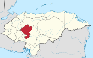
La Libertad is a municipality in the Honduran department of Comayagua.
Kalikot District, a part of Karnali province, is one of the seventy-seven districts of Nepal. The district, with Manma as its district headquarters, covers an area of 1,741 km2 (672 sq mi), had a population of 105,580 in 2001 and 136,948 in 2011. In September 2005, in a bid to encourage a change in social attitudes, the government announced that it would provide rice to any family that had recently had a girl born.

Ayoun al Atrous is a town in southern Mauritania. It is located at around 16°40′0″N9°37′0″W. It is the capital of Hodh El Gharbi region.
Cañaveral de León is a town and municipality located in the province of Huelva, Spain. According to the 2005 census, it has a population of 419 inhabitants and covers a 35 km2 area. It sits at an altitude of 533 m above sea level, and is 134 km from the capital.
Moriles is a town in the province of Córdoba. In 2018 it had a population of 3,726. The municipality covers an area of about 20 km2 and has a population density of about 194 inhabitants/km2. The town is located about 65 km south of the provincial capital, Córdoba, at an altitude of 375 m above sea level, at co-ordinates 37°26′0″N4°37′0″W.

Arroyo de San Serván is a municipality located in the province of Badajoz, Extremadura, Spain. According to the 2012 census (INE), the municipality has a population of 4267 inhabitants. The town's first census was held in 1842, as part of Badajoz.
Campillo de Llerena is a municipality located in the province of Badajoz, Extremadura, Spain. According to a 2005 census (INE), the municipality has a population of 1,624 inhabitants.
Entrín Bajo is a municipality located in the province of Badajoz, Extremadura, Spain. According to the 2005 census (INE), the municipality has a population of 605 inhabitants.

La Garrovilla is a municipality located in the province of Badajoz, Extremadura, Spain. According to the 2010 census (INE), the municipality has a population of 2490 inhabitants.

La Lapa is a municipality located in the province of Badajoz, Extremadura, Spain. According to the 2006 census (INE), the municipality has a population of 314 inhabitants.

Montemolín is a municipality located in the province of Badajoz, Extremadura, Spain. According to the 2005 census (INE), the municipality has a population of 1582 inhabitants.

Talavera la Real is a municipality located in the province of Badajoz, Extremadura, Spain. According to the 2006 census (INE), the municipality has a population of 5255 inhabitants.

Torremayor is a municipality located in the province of Badajoz, Extremadura, Spain. According to the 2005 census (INE), the municipality has a population of 1020 inhabitants.
Valverde de Burguillos is a municipality located in the province of Badajoz, Extremadura, Spain. According to the 2005 census (INE), the municipality has a population of 326 inhabitants.
Valverde de Leganés is a municipality located in the province of Badajoz, Extremadura, Spain. According to the 2005 census (INE), the municipality has a population of 3894 inhabitants.
Cabañas Raras is a village and municipality located in the region of El Bierzo. According to the 2010 census (INE), the municipality has a population of 1,329 inhabitants.

Nogales is a Spanish municipality in the province of Badajoz, Extremadura. It has a population of 692 (2007) and an area of 80.7 km².

Trujillanos is a Spanish municipality in the province of Badajoz, Extremadura, 9 km from Mérida. It has a population of 1,376 (2020) and an area of 20.3 km2.
Calderbank is a hamlet in the Canadian province of Saskatchewan located in Morse No. 165.


