
Interstate 20 (I‑20) is a major east–west Interstate Highway in the Southern United States. I‑20 runs 1,535 miles (2,470 km) beginning near Kent, Texas, at I-10 to Florence, South Carolina, at I-95. Between Texas and South Carolina, I‑20 runs through northern Louisiana, Mississippi, Alabama, and Georgia. The major cities that I-20 connects to includes Fort Worth, Texas; Dallas, Texas; Shreveport, Louisiana; Jackson, Mississippi; Birmingham, Alabama; Atlanta, Georgia; Augusta, Georgia; and Columbia, South Carolina.

The Mancunian Way is a two mile long elevated motorway in Manchester, England. It is officially made up of the A57(M) and A635(M) motorways, although the latter does not appear on road signs for practical reasons. It is also part of two other roads: the A57 to the west, which runs east–west through Greater Manchester linking the M602 and M67 motorways, and a short section of non-motorway A635 to the east. Part of this non-motorway section collapsed on 14 August 2015 due to a sinkhole.

State Route 635 is a north–south state highway in the northwestern portion of the U.S. state of Ohio. The southern terminus of SR 635 is at SR 18 in Bascom. Its northern terminus is approximately 1 mile (1.6 km) east of Helena at a T-intersection with US 6.

The President George Bush Turnpike (PGBT) is a 52-mile (84 km) toll road running through the northern, northeastern and western suburbs, forming a partial loop around Dallas, Texas, United States. It is named for George H. W. Bush, the 41st President of the United States. At its west end near Belt Line Road in Irving, State Highway 161 continues southwest to Interstate 20 (I-20) in Grand Prairie. The discontinuous free frontage roads along the turnpike from I-35E in Carrollton east to its end at I-30 in Garland are assigned the State Highway 190 designation. SH 190 signage appears only along the Garland, Richardson, Plano, and Carrollton sections of the frontage road with the undersign "frontage road only". At intersections with city streets, only the Bush Turnpike signs are displayed, not the SH 190 signage. Prior to the construction of the main lanes as a tollway, SH 190 was used as the name of the planned main lanes too. Similarly, the part west of I-35E was planned as part of SH 161. Bush Turnpike is signed as a north–south road from I-20 to I-35E, an east–west road from I-35E to the Merritt Main Lane Gantry and as a north–south road from the Merritt Main Lane Gantry to I-30, as Bush Turnpike makes a nearly 90-degree curve in both places.
Interstate 635 (I-635) is a connector highway between Interstate 35 in Overland Park, Kansas and Interstate 29 in Kansas City, Missouri, approximately 12 miles long. It is mostly in the U.S. state of Kansas, servicing the city of Kansas City, Kansas, but extends into Kansas City, Missouri as well. The freeway's southern terminus is at a stack interchange with I-35. South of this, the mainline becomes an expressway carrying U.S. 69.
Interstate 635 (I-635) is a 37-mile-long (60 km) partial loop around Dallas, Texas, in the United States between I-20 in Balch Springs and State Highway 121 (SH 121) at the north entrance of the Dallas-Fort Worth International Airport in Grapevine. It intersects I-35E at exits 27B–C, but does not connect with I-35W. It is known locally as the Lyndon B. Johnson Freeway, or LBJ, named after Lyndon B. Johnson, the former U.S. Senator from Texas, 37th Vice President, and the 36th President of the United States.
Central Expressway is a north–south highway in Dallas, Texas (USA) and surrounding areas. The best-known section is the North Central Expressway, a name for a freeway section of U.S. Highway 75 between downtown Dallas and McKinney, Texas. The southern terminus is at an intersection with "hidden" Interstate 345 and Woodall Rodgers Expressway. From south of Main Street and its crossing under the Interstate 45 overhead in downtown Dallas, Central Expressway became the South Central Expressway, renamed César Chávez Boulevard on April 9, 2010.

Interstate 35E (I-35E), an Interstate Highway, is the eastern half of I-35 where it splits to serve the Dallas/Fort Worth metropolitan area. I-35 splits into two branch routes, I-35W and I-35E at Hillsboro. I-35E travels northward for 97 miles (156 km), maintaining I-35's sequence of exit numbers. It travels through Dallas before rejoining with I-35W to reform I-35 in Denton. This is one of two pairs of suffixed Interstates that has not been eliminated; I-35 also splits into I-35E and I-35W in Minneapolis–Saint Paul, Minnesota.
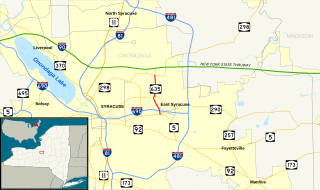
New York State Route 635 (NY 635) is a state highway located in the vicinity of Syracuse in Onondaga County, New York, in the United States. It extends for 2.25 miles (3.62 km) along Thompson Road from an intersection with Erie Boulevard (NY 5) in Syracuse to Carrier Circle in DeWitt, where NY 635 connects to both the New York State Thruway and NY 298. Along the way NY 635 also meets I-690. The route was assigned in 1980 after the section of Thompson Road between NY 290 and Carrier Circle was acquired by the state of New York.
Upper Matecumbe Key is an island in the upper Florida Keys.
Highway 982 is a provincial highway in the east central region of the Canadian province of Saskatchewan. It runs from Highway 8 to Highway 9. Highway 982 is about 57 km (35 mi) long.
Highway 321 is a highway in the Canadian province of Saskatchewan. It runs from Highway 21 near Liebenthal to the Alberta border, where it becomes Highway 545. Highway 321 is about 33 km (21 mi) long.
A connector is a highway or freeway road that connects to another highway or freeway. It can be part of an interchange such as the MacArthur Maze or a longer roadway such as the 13-mile-long (21 km) Interstate 635.

In the U.S. state of Texas, U.S. Highway 75 (US 75) is a U.S. Highway that begins in Dallas and heads north to the Oklahoma state line.
Highway 601 is a highway in the Canadian province of Saskatchewan. It runs from Highway 1 near Raymore to Township Road 183 near Airsville. Highway 601 is about 60 km long.
Saskatchewan Highway 658 connects Saskatchewan Highway 4 near Red Pheasant Indian Reserve 108 to SK Hwy 4 near Battleford. Highway 658 travels around Mosquito Indian Reserve 109, whereas Highway 4 travels north through the Indian Reserve. To the north of Mosquito Indian Reserve 109 is Grizzly Bear's Head and Lean Man Indian Reserve. The centre of Battleford is 1.5 kilometres (0.93 mi) from the Highway 658 Highway 4 junction. The length of Highway 658 is 41.2 kilometres (25.6 mi).
Chesterfield No. 261 is a rural municipality in the Canadian province of Saskatchewan, located in the Census Division 8. The seat of the municipality is located in the Town of Eatonia.


