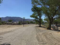
Schurz, Nevada | |
---|---|
Coordinates: 38°57′56″N118°49′37″W / 38.96556°N 118.82694°W | |
Country | United States |
State | Nevada |
County | Mineral |
Founded | 1891 |
Named for | Carl Schurz |
Area | |
• Total | 11.46 sq mi (29.68 km2) |
• Land | 11.24 sq mi (29.10 km2) |
• Water | 0.22 sq mi (0.57 km2) |
Elevation | 4,127 ft (1,258 m) |
Population | |
• Total | 656 |
• Density | 58.38/sq mi (22.54/km2) |
Time zone | UTC-8 (PST) |
• Summer (DST) | UTC-7 (PDT) |
ZIP code | 89427 |
Area code | 775 |
FIPS code | 32-65400 |
GNIS feature ID | 0858175 |
Schurz is an unincorporated community and census-designated place (CDP) in Mineral County, Nevada, United States. The population was 656 at the 2020 census. [2] It is located on the Walker River Indian Reservation and is the burial place of Wovoka, the Paiute messiah who originated the Ghost Dance movement.
Schurz was founded in 1891. [3] The town was named after Secretary of the Interior Carl Schurz. [4] A post office has been in operation at Schurz since 1891. [5]
Schurz is located in northwestern Mineral County at the junction of U.S. Route 95 and U.S. Route 95 Alternate. U.S. 95 leads south 34 miles (55 km) to Hawthorne, the Mineral county seat, and north 37 miles (60 km) to Fallon, while U.S. 95A leads west 23 miles (37 km) to Yerington.
According to the U.S. Census Bureau, the Schurz CDP has a total area of 11.5 square miles (30 km2), all land. [1]
Census | Pop. | Note | %± |
---|---|---|---|
2000 | 721 | — | |
2010 | 658 | −8.7% | |
2020 | 656 | −0.3% | |
U.S. Decennial Census [6] |
As of the census [7] of 2000, there were 721 people, 281 households, and 180 families residing in the CDP. The population density was 11.9 inhabitants per square mile (4.6/km2). There were 312 housing units at an average density of 5.2 per square mile (2.0/km2). The racial makeup of the CDP was 9.99% White, 0.69% African American, 83.63% Native American, 0.14% Asian, 0.14% Pacific Islander, 1.66% from other races, and 3.74% from two or more races. Hispanic or Latino of any race were 9.57% of the population.
There were 281 households, out of which 35.2% had children under the age of 18 living with them, 37.4% were married couples living together, 20.6% had a female householder with no husband present, and 35.6% were non-families. 28.8% of all households were made up of individuals, and 8.9% had someone living alone who was 65 years of age or older. The average household size was 2.57 and the average family size was 3.17.
In the CDP, the population was spread out, with 32.9% under the age of 18, 8.2% from 18 to 24, 25.4% from 25 to 44, 21.6% from 45 to 64 and 11.9% who were 65 years of age or older. The median age was 35 years. For every 100 females, there were 95.9 males. For every 100 females age 18 and over, there were 88.3 males.
The median income for a household in the CDP was $24,265, and the median income for a family was $26,964. Males had a median income of $29,375 versus $23,958 for females. The per capita income for the CDP was $10,886. About 19.8% of families and 26.5% of the population were below the poverty line, including 23.7% of those under age 18 and 30.6% of those age 65 or over.
The Köppen Climate System classifies the weather in this area as semi-arid, abbreviated BSk. This climate type occurs primarily on the periphery of true deserts in low-latitude semiarid steppe regions. [8]
Climate data for Schurz, Nevada | |||||||||||||
---|---|---|---|---|---|---|---|---|---|---|---|---|---|
Month | Jan | Feb | Mar | Apr | May | Jun | Jul | Aug | Sep | Oct | Nov | Dec | Year |
Mean daily maximum °C (°F) | 8 (46) | 12 (53) | 16 (61) | 20 (68) | 24 (76) | 29 (84) | 34 (93) | 33 (92) | 29 (84) | 22 (72) | 15 (59) | 9 (49) | 21 (70) |
Mean daily minimum °C (°F) | −8 (17) | −6 (22) | −3 (27) | 1 (33) | 5 (41) | 8 (47) | 12 (53) | 10 (50) | 5 (41) | 0 (32) | −4 (24) | −7 (19) | 1 (34) |
Average precipitation mm (inches) | 13 (0.5) | 13 (0.5) | 10 (0.4) | 13 (0.5) | 15 (0.6) | 10 (0.4) | 7.6 (0.3) | 7.6 (0.3) | 7.6 (0.3) | 10 (0.4) | 10 (0.4) | 15 (0.6) | 140 (5.4) |
Source: Weatherbase [9] |
Mineral County is a county located in the U.S. state of Nevada. As of the 2020 census, the population was 4,554, making it the fifth-least populous county in Nevada. Its county seat is Hawthorne.
East Whittier is an unincorporated community in Los Angeles County, California, United States. The population was 9,757 at the 2010 census, up from 9,538 at the 2000 census. For statistical purposes, the United States Census Bureau has defined this community as a census-designated place (CDP). The name was changed from East La Mirada in 2012, likely due to its precise location in relation to the city of Whittier. The previous delineation of East Whittier CDP occurred during the 1960 census, when the area recorded a population of 19,884.
South Whittier is an unincorporated community in Los Angeles County, California just south of the city of Whittier. For statistical purposes, the United States Census Bureau has defined South Whittier as a census-designated place (CDP). As of the 2020 census, the CDP had a total population of 56,415, down from 57,156 at the 2010 census.
Lake Nacimiento is a census-designated place (CDP) in northern San Luis Obispo County, California, United States.
Manton is a census-designated place (CDP) partially in Tehama County, California, United States. It is also in Shasta County. The population in the Tehama County portion was 347 at the 2010 census, down from 372 at the 2000 census.
Mineral is a boundaried but unincorporated forest village in Tehama County, California, United States. It has been part of a much larger census-designated place since 1980, for which the population was 123 at the 2010 census, down from 143 at the 2000 census.
Shannon is an unincorporated community and census-designated place (CDP) in Floyd County, Georgia, United States. It is part of the Rome, Georgia Metropolitan Statistical Area. The population was 1,862 at the 2010 census.
Mardela Springs is a town in Wicomico County, Maryland, United States. The population was 357 at the 2010 census. It is included in the Salisbury, Maryland-Delaware Metropolitan Statistical Area.
Rancho San Diego is a census-designated place (CDP) in the East County region of San Diego County, California. The population was 21,858 at the 2020 census, up from 21,208 at the 2010 census. The area was developed as subdivisions beginning in the 1970s.
De Borgia is an unincorporated community and census-designated place (CDP) in Mineral County, Montana, United States. The population was 91 at the 2020 census.
Cal-Nev-Ari is a census-designated place on U.S. Route 95 in Clark County, Nevada, United States, near the state's southernmost point. As of the 2010 census, the town had a population of 244. The town's name is a syllabic abbreviation of California, Nevada and Arizona.
Gardnerville is an unincorporated town in Douglas County, Nevada, adjacent to the county seat of Minden. The population was 6,211 at the 2020 census.
Gardnerville Ranchos is a census-designated place in Douglas County, Nevada, United States. As of the 2010 census, the population was 11,312. The area is the namesake for the Gardnerville Ranchos Micropolitan Statistical area which includes other areas of Douglas County.
Hawthorne is an unincorporated community and census-designated place (CDP) in Mineral County, Nevada, United States. As of the 2020 census, the population was 3,118. It is the county seat of Mineral County. The nearby Hawthorne Army Depot is the primary economic base of the town.
Sutcliffe is a census-designated place (CDP) in Washoe County, Nevada, United States. The population was 253 at the 2010 census. It is part of the Reno–Sparks Metropolitan Statistical Area.
Garfield is a census-designated place (CDP) in Travis County, Texas, United States. As of the 2020 census, the CDP population was 1,825.
Newington is a census-designated place (CDP) in Fairfax County, Virginia, United States. As of the 2020 census, the population was 13,223. The population was 12,943 at the 2010 census. The 2010 census showed a significant decrease after half the population was split off to the newly created Newington Forest CDP.
Wiley Ford is a census-designated place (CDP) in Mineral County, West Virginia, United States and part of the 'Cumberland, MD-WV Metropolitan Statistical Area'. The population was 1,026 at the 2010 census.
Boaz is a census-designated place (CDP) in Wood County, West Virginia, United States. It is part of the Parkersburg-Marietta-Vienna, WV-OH Metropolitan Statistical Area. As of the 2020 census, the CDP population was 1,321.
West Rutland is a town in Rutland County, Vermont, United States. The population was 2,214 at the 2020 census. The town center, located in the south-central portion of the town and where about 87% of the population resides, is defined by the U.S. Census Bureau as a census-designated place (CDP). The town is part of the Rutland micropolitan NECTA.