Jayapura is the capital and largest city of the Indonesian province of Papua. It is situated on the northern coast of New Guinea island and covers an area of 940.0 km2 (362.9 sq mi). The city borders the Pacific Ocean and Yos Sudarso Bay to the north, Sandaun Province of Papua New Guinea to the east, Keerom Regency to the south, and Jayapura Regency to the west. It is the most populous city in the Indonesian part of New Guinea with a population of 256,705 at the 2010 census and 303,760 at the 2020 Census, as well as one of the most populous on the island alongside Papua New Guinea's capital Port Moresby.

Kuningan is a town and district located in eastern West Java, Indonesia, between Cirebon and Tasikmalaya, about 200 km east of Jakarta. It is the administrative center of Kuningan Regency. The district is located east of Mount Cereme/Ciremai, the highest mountain in West Java. The eastern part of the district is a valley. The district's landmark is a horse, called Kuda Kuningan and its motto is Kuningan Aman (Safe) Sehat (Healthy) Rindang (Leafy) Indah (Beautiful), abbreviated as Kuningan ASRI.

Wonosobo Regency is a regency in Central Java province in Indonesia. Its capital is Wonosobo, located at 7.3684940°S 109.8983841°E, about 120 km from Semarang. The regency is located in Dieng Plateau. Its area is 984.68 km² and its population was 754,883 at the 2010 Census and 879,124 at the 2020 Census.

Lamongan Regency is a regency (kabupaten) of East Java, Indonesia. It has a total land area of approximately 1,812.8 km2 (699.9 sq mi) or + 3.78% of the area of East Java Province. With a length of 47 km (29 mi) along the coastline, the sea area of Lamongan Regency is about 902.4 km2 (348.4 sq mi), if calculated to a distance of 12 miles (19 km) across the ocean surface. At the 2010 census it had a population of 1,179,059; the 2020 Census produced a total of 1,379,628. The administrative centre is the town of Lamongan.
Magetan Regency is a regency (kabupaten) of East Java Province, Indonesia. It is an inland regency, and lies in the west of the province, adjoining Central Java Province. It covers an area of 668.84 km2 and had a population of 620,442 at the 2010 Census and 670,812 at the 2020 Census. The administrative headquarters is in the town of Magetan.

Nganjuk Regency is a regency (kabupaten) of East Java Province, Indonesia. It bordered Bojonegoro Regency in the north, Jombang Regency in the east, Kediri Regency in the south, and Madiun Regency in the west. It covers an area of 1,224.33 sq. km, and had a population of 1,017,030 at the 2010 Census and 1,103,902 at the 2020 Census. The administrative centre of the regency is the town of Nganjuk. The current regent is Novi Rahman Hidayat.

Situbondo Regency is a regency (kabupaten) of East Java province, Indonesia. It covers an area of 1,638.50 km2, and had a population of 647,619 at the 2010 Census and 685,967 at the 2020 Census. It is located in east end of Java before Banyuwangi. The administrative centre is Situbondo, a small town within the regency. One of the famous tourist sites is Baluran National Park.

Gianyar Regency is a regency (kabupaten) in the Indonesian province and island of Bali, Indonesia. It has an area of 368.0 km2 and had a population of 469,777 at the 2010 Census, and 515,344 at the 2020 Census, making it the second most densely populated district in Bali. Its regency seat is the town of Gianyar. The civil registry survey of April 2011 listed 480,447 people, of which 469,929 were classified as Hindu.
Wamena is the capital town of the Jayawijaya Regency of Indonesia. It is the largest town in Indonesian Papua's highlands, in the Baliem Valley and had a population of 31,724 at the 2010 Census and 64,967 at the 2020 Census. Wamena is the urban centre of a rural area housing highland West Papua's highest concentration of population, with over 300,000 people inhabiting the Baliem Valley and surrounding areas. These people belong to a number of related ethnic groups, the most prominent of which are Dani, Lani and Yali.

Jayapura Regency is one of the regencies (kabupaten) in Papua Province of Indonesia. It is situated to the west of but does not include the city of Jayapura. Previously covering most of the north-east portion of Papua Province, it was reduced substantially in extent from 12 November 2002, when the eastern districts were split off to form a new Keerom Regency and the western districts were split off to form a new Sarmi Regency. It now covers an area of 17,516.6 km2, and had a population of 111,943 at the 2010 Census and 166,171 at the 2020 Census. The administrative centre is the town of Sentani, with 71,174 inhabitants in 2020.

Sarmi Regency is one of the regencies (kabupaten) in Papua Province of Indonesia. It was formed from the western districts then within Jayapura Regency with effect from 12 November 2002. It covers an area of 18,034.0 km2, and had a population of 32,971 at the 2010 Census and 41,515 at the 2020 Census. The regency's administrative centre is at the town of Sarmi.

Mimika Regency is one of the regencies (kabupaten) in Papua Province, Indonesia. It covers an area of 21,693.51 km2, and had a population of 182,001 at the 2010 Census, but grew to 311,969 at the 2020 Census. The administrative centre is the town of Timika, which lies within Mimika Baru District, which had 142,909 inhabitants in 2020.
Keerom Regency is one of the regencies (kabupaten) in the Papua Province of Indonesia. It was formed from the eastern districts then within Jayapura Regency with effect from 12 November 2002. It covers an area of 9,365 km2, and had a population of 48,536 at the 2010 Census and 61,623 at the 2020 Census. The regency's administrative centre is at Waris. It borders Green River Rural LLG and Amanab Rural LLG of Sandaun Province, Papua New Guinea.
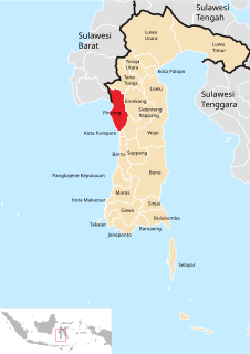
Pinrang Regency is one of the twenty-one regencies in South Sulawesi Province of Indonesia. Pinrang town is the administrative capital of Pinrang Regency. The regency covers 1,961.77 km2 and had a population of 351,161 at the 2010 Census and 403,994 at the 2020 Census.
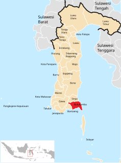
Bulukumba Regency is a regency in the southeast corner of South Sulawesi Province, Indonesia. It covers an area of 1,154.58 km2, and had a population of 394,757 at the 2010 Census and 437,607 at the 2020 Census. The town of Ujung Bulu is its capital.

Lamandau Regency is one of the thirteen regencies which comprise the Central Kalimantan Province on the island of Kalimantan (Borneo), Indonesia. The town of Nanga Bulik is the capital of Lamandau Regency. The population of Lamandau Regency was 63,199 at the 2010 Census, and 97,611 at the 2020 Census.

Enrekang Regency is a regency of South Sulawesi Province of Indonesia. It covers an area of 1,786.01 km2 and had a population of 190,175 at the 2010 Census and 225,172 at the 2020 Census. The principal town lies at Enrekang.
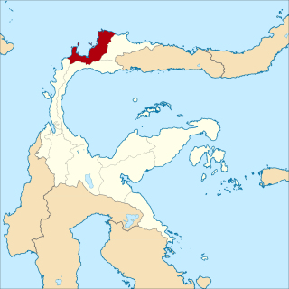
Tolitoli Regency is a regency of Central Sulawesi Province of Indonesia. It covers an area of 4,079.77 km2 and had a population of 211,296 at the 2010 Census and 225,154 at the 2020 Census. It was previously part of another regency together with current Buol Regency, named Buol Tolitoli Regency, but was split in early 2000 after rapid decentralization of the Indonesian government. Its regency seat located Tolitoli, which is a port town and where the its population concentrated.