Sequoyah Hills

Last updated

Entrance to Sequoyah Hills at intersection of Cherokee Boulevard and Kingston Pike Sequoyah-hills-entrance-tn1.jpg
Entrance to Sequoyah Hills at intersection of Cherokee Boulevard and Kingston Pike

Sequoyah Hills is a neighborhood in Knoxville, Tennessee, United States, named for the Cherokee scholar Sequoyah. [1] It is located off Kingston Pike, between the city's downtown and West Knoxville. Initially developed in the 1920s, Sequoyah Hills was one of Knoxville's first suburbs and today is home to some of the city's most affluent residents. The neighborhood contains numerous notable examples of mid-20th century residential architecture, with houses designed by architects such as Charles I. Barber, Benjamin McMurry, and Francis Keally. [2]

Contents

Originally an agricultural area called Looney's Bend, the modern Sequoyah Hills neighborhood is largely rooted in the development efforts of 1920s-era visionary entrepreneurs E. V. Ferrell, who developed the Scenic Drive area, and Robert L. Foust, who established the "Talahi" subdivision in the vicinity of Cherokee Boulevard and Talahi Drive. [2] Foust and Ferrell advertised their respective developments as utopian getaways where Knoxville's elite could escape the ills of congested city life. [3] While the Great Depression led to the financial collapse of the Talahi project and Foust's subsequent suicide, Sequoyah Hills nevertheless continued to develop over the years as Foust had envisioned. [2]

Cherokee Boulevard was home to Knoxville's first Dogwood Arts Trail, which was established in 1955. [4] In 1979, the Talahi Improvements, which consist of several early landscape elements from Foust's Talahi development, were listed on the National Register of Historic Places. [3]

Location

Sequoyah Hills is located on a peninsula created by a bend of the Tennessee River known as Looney's Bend. The neighborhood is bounded by the river on the east, south, and west, and by Kingston Pike (US-70/US-11) on the north, though the Kingston Pike/Sequoyah Hills Neighborhood Association includes several streets just north of Kingston Pike. The area is generally hilly, with a 10 to 15-foot bluff rising above the rivershore along most of the neighborhood's southern edge. From the edge of the bluff, the land gradually slopes upward, reaching approximately 40 feet (12 m) above the river, affording houses along the upper slopes sweeping views of the river and Knoxville in the distance.

Sequoyah Park, which occupies most of the south side of the neighborhood, lies in the floodplain between the rivershore and base of the bluff. Cherokee Boulevard, a boulevard with a grassy median dividing the right and left lanes, runs in a U-shape around the edge of the peninsula. The other main road, Scenic Drive/Southgate Road, runs roughly north-to-south across the center of the peninsula. A small commercial center, known as Council Point, [2] is concentrated around the intersection of Kenesaw and Keowee avenues.

History

Early history

Late Woodland burial mound along Cherokee Boulevard Cherokee-boulevard-mound-tn1.jpg
Late Woodland burial mound along Cherokee Boulevard

What is now Sequoyah Hills was inhabited by Native Americans as early as the Late Woodland period (c. 5001100 A.D.), as indicated by a 1,000-year-old Indian mound that rises in the median of Cherokee Boulevard. [5] By the 18th century, the area was under control of the Cherokee, whose Overhill towns lay along the Little Tennessee River to the southwest. The neighborhood's namesake, Sequoyah, was born in the Overhill town of Tuskegee around 1767. [6]

In 1796, Moses Looney, who had served in various capacities with the failed State of Franklin during the 1780s, [7] acquired a 700-acre (280 ha) tract of land in what is now Sequoyah Hills. [2] He and his descendants remained on the land for several decades, and the area became known as "Looney's Bend." Other early landowners in the Sequoyah Hills area included future Knoxville mayor James Park, who purchased a 200-acre (81 ha) tract in 1804; William Lyon, who built a house and mill near the modern intersection of Lyon's View Pike and Northshore Drive around 1810; and Drury Armstrong (builder of Crescent Bend), who acquired a large tract of land west of modern Scenic Drive in 1846. [2]

The oldest house still extant in Sequoyah Hills, which currently stands at 715 Scenic Drive, was originally built in the 1850s as a tenant house on the farm of Allen Johnson. [2] Around 1814 George White, son-in-law of James Park and grandson of Knoxville founder James White, built a house along what is now Woodhill Place. While this house is no longer standing, foundation remnants of a barn that accompanied the house can be seen along Scenic Drive. [2]

Early development

The "old" Cherokee Country Club, circa 1910 Old-cherokee-country-club-tn1.jpg
The "old" Cherokee Country Club, circa 1910

In 1890 Francis Huger, superintendent of the East Tennessee, Virginia and Georgia Railway, acquired over 450 acres (180 ha) in Sequoyah Hills with the intent of moving a steel mill to the area. The Panic of 1893 doomed this venture, however, and the land was distributed to Huger's creditors in 1908. [2] Knox County road commissioner Peter Blow built a house on the south bank of the river opposite Sequoyah Hills in 1910, where he operated a ferry. Blow's Ferry Road, which connected the ferry to Kingston Pike, is believed to have been built along a trail that once accessed a cemetery containing the graves of Civil War soldiers and slaves. [2]

In 1907, several Knoxville businessmen established the Cherokee Country Club on Lyon's View Pike and erected a clubhouse on a hill with a commanding view of the river valley and the Great Smoky Mountains beyond. The original clubhouse was eventually demolished and replaced with the current building, designed by the noted Knoxville architectural firm Baumann and Baumann, in 1928. [1] In 1913, trolley tracks were extended along Kingston Pike to its Lyon's View Pike junction, aiding in the development of the area. [5] What is now Sequoyah Hills was annexed by Knoxville in 1917. [8]

With the advent of the automobile, affluent Knoxvillians began fleeing the congested urban neighborhoods for more spacious areas on the city's periphery. By 1920, several elegant residences, such as the H.L. Dulin House (1915) on Kingston Pike and the C. Powell Smith (1913) and E.C. Mahan (1920) residences on Lyon's View Pike, had been built near Sequoyah Hills. [2] In 1921, Regal Manufacturing president S. D. Coykendall commissioned noted Knoxville architectural firm Barber & McMurry to build a house on what is now Scenic Drive. [2]

Talahi and Sequoyah Hills

In the mid-1920s, E. V. Ferrell began major residential development in Sequoyah Hills. To connect his holdings along the peninsula, he built Cherokee Boulevard (named for the Indian mound in the road's median) [1] [3] and improved Scenic Drive as far as its modern intersection with Bluff and Southgate (a gate at this point inspired the name of the latter). [2] Ferrell chose the name "Sequoyah Hills" to match the name of Cherokee Boulevard. [3] By 1924, houses had been built at 901, 919, 927 and 937 Scenic Drive, [2] and 50 lots had been sold by the end of the decade. [3]

Prairie-style house along Scenic Drive, built in 1924 Scenic-drive-sequoyah-hills-tn4.jpg
Prairie-style house along Scenic Drive, built in 1924

In 1926 Robert Foust, a partner in the real estate firm Alex McMillan Company, purchased a 100-acre (40 ha) tract of land on the southeast section of Looney's Bend with plans to develop a premier subdivision for Knoxville. [3] Foust envisioned a neighborhood for those "who insist upon and can afford the best," and where "all the ugliness of city life has been shut out." [3] He named the new subdivision "Talahi," Cherokee for "standing oak forest." [1] The new neighborhood, Foust believed, would bring together "an Indian past, a technical future, and a natural forest setting." [3]

Foust recruited landscape designer Earle S. Draper to oversee Talahi's complex landscape designs. The plans called for curvilinear streets, preservation of mature trees wherever possible, and underground utilities. [3] Lot sizes were to be no less than 5,000 square feet and were restricted to single-family homes. [3] Foust's restrictions called for all houses to be built in English Cottage or American Colonial Revival styles (this restriction was abandoned by subsequent developers). [3] A country club was to be built along the river bank. [3]

Between 1927 and 1929, Foust constructed several landscape features, including entrance pylons, fountains, and a park (Papoose Park). Talahi was opened to sales in the spring of 1929. [3] Only one lot940 Cherokee Boulevardwas sold before the stock market crashed later that year. In the early 1930s, lots in Talahi, originally marketed in the $4,000 to $10,000 range, were selling for just $600. [3] His finances in ruins, Foust committed suicide in September 1933. [3]

Notable buildings and structures

Talahi Improvements
Talahi-panther-fountain-tn1.jpg
Panther Fountain
USA Tennessee location map.svg
Red pog.svg
Usa edcp location map.svg
Red pog.svg
LocationCherokee Boulevard, Iskagna Drive, Kenesaw Avenue, Keowee Drive, Talahi Drive, Taliluna Avenue and Tugaloo Drive
Knoxville, Tennessee
Coordinates 35°56′09″N83°57′24″W / 35.93583°N 83.95667°W / 35.93583; -83.95667
Area18 acres (7.3 ha) [3] [9]
Built1929 [3]
NRHP reference No. 79002447
Added to NRHPDecember 26, 1979

Talahi Improvements

Gatepost along Cherokee Boulevard Talahi-pillar-detail-tn1.jpg
Gatepost along Cherokee Boulevard

Before the stock market crash ruined his development efforts in 1929, Foust managed to complete several landscape improvements in the proposed Talahi subdivision. These include gateposts at either end of the subdivision along Cherokee Boulevard, two fountains, a park, streetlight standards, and stone benches. The roads were originally paved in concrete, which has been preserved along parts of Talahi Drive, Iskagna Drive, and Taliluna Avenue. [3]

The Talahi Improvements are concentrated primarily between the intersections of Talahi Drive and Cherokee Boulevard and Talahi Drive and Taliluna Avenue, with islands in both intersections containing the two fountains, called "Sunhouse Fountain" and "Panther Fountain," respectively. Papoose Park, which is surrounded by an iron fence, is situated in the median along Talahi Drive between the two intersections. Stone walls with inset benches form a broken circle around the Cherokee Boulevard/Talahi Drive intersection, with the north walls opening toward Papoose Park, and the south walls opening toward the lake, where the proposed country club was to be built. [3]

Sunhouse Fountain is a circular stone fountain with twelve small posts, each decorated with a sunburst motif, and each originally surmounted by a bronze frog (the frogs have since been removed). [3] Panther Fountain is a circular fountain with a central obelisk resting atop a base of varying geometric shapes. Water was discharged through panther heads on each of the four sides of the base. Cherokee motifs decorate the gateposts, pylons, and fountains, suggesting inspiration from both Cherokee folklore and the Art Deco movement's emphasis on abstract figures. [3]

Houses

UT president's house at 940 Cherokee Boulevard Cherokee-boulevard-house-tn3.jpg
UT president's house at 940 Cherokee Boulevard

Other buildings

Sequoyah Elementary School Sequoyah-school-tn1.jpg
Sequoyah Elementary School

Notable residents

Notable residents of Sequoyah Hills have included Senator Howard H. Baker, Jr., businessman Jim Clayton (owner of Clayton Homes), author Alex Haley, members of the Haslam family including Governor Bill Haslam, [2] author Cormac McCarthy, actress Patricia Neal, Tennessee Volunteers football coach Robert R. Neyland, actor David Keith, Knoxville mayors George Roby Dempster and Benjamin Morton, and photographer James Edward Thompson. [2]

Related Research Articles

<span class="mw-page-title-main">Tuskegee (Cherokee town)</span> Former Overhill Cherokee town in Monroe County, Tennessee

<span class="mw-page-title-main">Chota (Cherokee town)</span> United States historic place

Chota is a historic Overhill Cherokee town site in Monroe County, Tennessee, in the southeastern United States. Developing after nearby Tanasi, Chota was the most important of the Overhill towns from the late 1740s until 1788. It replaced Tanasi as the de facto capital, or 'mother town' of the Cherokee people.

<span class="mw-page-title-main">U.S. Route 11W</span> Suffixed section of U.S. Highway in Tennessee and Virginia in the United States

U.S. Route 11W (US 11W) is the western branch of US 11 from the twin cities of Bristol, Tennessee/Bristol, Virginia, where US 11 splits into US 11E and US 11W, to Knoxville, Tennessee, where the two highways rejoin. The highway serves the Appalachia region's Ridge-and-Valley section of East Tennessee, bounded by the Clinch Mountain ridge to the north and the Holston River to the south. US 11W from Bristol to Bean Station and Blaine to Knoxville are designated as part of the National Highway System.

<span class="mw-page-title-main">Westwood (Knoxville, Tennessee)</span> Historic house in Tennessee, United States

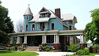
Westwood is a historic home located at 3425 Kingston Pike at the edge of the Sequoyah Hills area of Knoxville, Tennessee. Also known as the Adelia Armstrong Lutz House, the house was built in 1890 by John Lutz and his wife, artist Adelia Armstrong Lutz, on land given to them by Adelia's father, Robert H. Armstrong. In 1984, the house was listed on the National Register of Historic Places for its architecture.

<span class="mw-page-title-main">Kingston Pike</span> Highway in Tennessee, U.S.

Kingston Pike is a highway in Knox County, Tennessee, United States, that connects Downtown Knoxville with West Knoxville, Farragut, and other communities in the western part of the county. The road follows a merged stretch of U.S. Route 11 (US 11) and US 70. From its initial construction in the 1790s until the development of the Interstate Highway System in the 1960s, Kingston Pike was the main traffic artery in western Knox County, and an important section of several cross-country highways. The road is now a major commercial corridor, containing hundreds of stores, restaurants, and other retail establishments.

<span class="mw-page-title-main">Tennessee State Route 71</span> State highway in Tennessee, United States

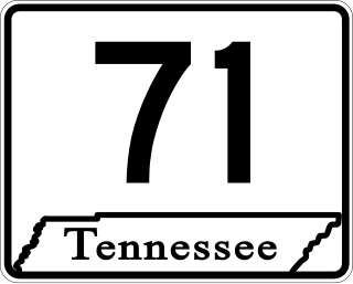
State Route 71 is a north–south state highway in Tennessee. For most of the length it is a "hidden" route, as it coincides with US 441 in all but a short section in Knoxville. The road begins at the North Carolina state line in Sevier County within the Great Smoky Mountains National Park at Newfound Gap and ends at an intersection with US 25W, SR 116, and SR 9 (hidden) in Rocky Top. Along its length SR 71 passes through Sevier County, a small portion of Blount County, Knox County, Anderson County, and in and out of Campbell County. Despite being signed on Hall of Fame Parkway in Knoxville, Tennessee, the Knox County TDOT map ignores SR 71 while SR 33 has a concurrency with US 441.

<span class="mw-page-title-main">Overhill Cherokee</span> 18th century Cherokee people who lived on the west side of the Appalachian Mountains

Overhill Cherokee was the term for the Cherokee people located in their historic settlements in what is now the U.S. state of Tennessee in the Southeastern United States, on the western side of the Appalachian Mountains. This name was used by 18th-century European traders and explorers from British colonies along the Atlantic coast, as they had to cross the mountains to reach these settlements.

<span class="mw-page-title-main">Chilhowee (Cherokee town)</span> Cherokee village site in Blount and Monroe Counties, Tennessee

<span class="mw-page-title-main">North Hills Historic District (Knoxville)</span> Historic district in Tennessee, United States

The North Hills Historic District is a residential subdivision in north Knoxville, Tennessee, United States, that was added to the National Register of Historic Places in September 2008 as a historic district. The subdivision was established in 1927 by the North Hills Corporation as a neighborhood of custom-built homes, catering to middle-class families. The historic district includes 130 houses on about 50 acres (20 ha). At the time of its listing on the National Register, it was described by the Tennessee Historical Commission as a good example of mid-20th century residential architecture.

<span class="mw-page-title-main">U.S. Route 441 in Tennessee</span> U.S. Highway in Tennessee

U.S. Route 441 stretches for 83.28 miles (134.03 km) through the mountains of East Tennessee, connecting Rocky Top with Knoxville, Sevierville, Gatlinburg, and the Great Smoky Mountains National Park, crossing into North Carolina at Newfound Gap. Near its northern terminus, US 441 crosses over Norris Dam and passes through Norris Dam State Park.

<span class="mw-page-title-main">U.S. Route 129 in Tennessee</span>

U.S. Route 129 is a north–south United States highway that runs for 52.8 miles (85.0 km) in East Tennessee, from the North Carolina state line, near Tapoco, to Knoxville. In Tennessee, the highway is completely overlapped by unsigned State Route 115. In the Greater Knoxville area, US 129 serves as a six-lane controlled-access highway known as Alcoa Highway.

<span class="mw-page-title-main">Old North Knoxville</span> Neighborhood in Knoxville, Tennessee, United States

Old North Knoxville is a neighborhood in Knoxville, Tennessee, United States, located just north of the city's downtown area. Initially established as the town of North Knoxville in 1889, the area was a prominent suburb for Knoxville's upper middle and professional classes until the 1950s. After a period of decline, preservationists began restoring many of the neighborhood's houses in the 1980s. In 1992, over 400 houses and secondary structures in the neighborhood were added to the National Register of Historic Places as the Old North Knoxville Historic District.

West Knoxville is a section of Knoxville, Tennessee, US. It is west of the city's downtown area. It stretches from Sequoyah Hills on the east to the city's border with Farragut on the west. West Knoxville is concentrated around Kingston Pike (US-70/US-11), and along with Sequoyah Hills includes the neighborhoods of Lyons View, Forest Hills, Bearden, West Hills, Westmoreland Heights, Cedar Bluff, and Ebenezer.

<span class="mw-page-title-main">Bearden, Knoxville</span> Neighborhood of Knoxville in Tennessee, United States

Bearden, also known as Bearden Village, is a neighborhood in Knoxville, Tennessee, United States, located along Kingston Pike in West Knoxville. Developed primarily as an agrarian community in the 19th century, this neighborhood now lies at the heart of one of Knoxville's major commercial corridors. Named for former Knoxville mayor and Tennessee state legislator, Marcus De Lafayette Bearden (1830–1885), the community was annexed by Knoxville in 1962.

<span class="mw-page-title-main">Lindbergh Forest</span> Historic house in Tennessee, United States

Lindbergh Forest is a neighborhood in Knoxville, Tennessee, United States, located off Chapman Highway (US-441) in South Knoxville, that is listed on the National Register of Historic Places as an historic district. Initially developed in the late 1920s as one of Knoxville's first automobile suburbs, the neighborhood is now noted for its late-1920s and early-1930s residential architecture, and the use of East Tennessee marble detailing. The neighborhood also contains two of Knoxville's five surviving Lustron houses. In 1998, several of its houses were added to the National Register of Historic Places as the Lindbergh Forest Historic District.

West Hills is a neighborhood in Knoxville, Tennessee, United States, located just off Kingston Pike in West Knoxville. Initially developed in the 1950s, West Hills was Knoxville's first major post-World War II subdivision, and the first subdivision to consist primarily of modern ranch-style houses. While West Knoxville experienced a boom in commercial development in the 1970s and 1980s, West Hills has managed to retain its residential character, due in large part to its aggressive neighborhood advocacy group, the West Hills Community Association.

<span class="mw-page-title-main">Baumann family (architects)</span> American architect

The Baumann family was a family of American architects who practiced in Knoxville, Tennessee, and the surrounding region, in the late 19th and early 20th centuries. It included Joseph F. Baumann (1844–1920), his brother, Albert B. Baumann, Sr. (1861–1942), and Albert's son, Albert B. Baumann, Jr. (1897–1952). Buildings designed by the Baumanns include the Mall Building (1875), the Church of the Immaculate Conception (1886), Minvilla (1913), the Andrew Johnson Building (1930), and the Knoxville Post Office (1934).

<span class="mw-page-title-main">BarberMcMurry</span> American architecture firm

BarberMcMurry, formerly Barber & McMurry, is an architecture firm based in Knoxville, Tennessee, USA. Founded in 1915 by Charles Irving Barber (1887–1962) and Benjamin Franklin McMurry, Sr. (1885–1969), the firm designed dozens of notable houses, churches, schools, and public facilities in Knoxville and the surrounding region in the early 20th century, several of which have been listed on the National Register of Historic Places. In recent decades, the firm has expanded its focus to include larger-scale projects, such as hospitals, stadiums and retail complexes.

Charles Ives Barber was an American architect, active primarily in Knoxville, Tennessee, and vicinity, during the first half of the 20th century. He was cofounder of the firm, Barber & McMurry, through which he designed or codesigned buildings such as the Church Street Methodist Episcopal Church, South, the General Building, and the Knoxville YMCA, as well as several campus buildings for the University of Tennessee and numerous elaborate houses in West Knoxville. Several buildings designed by Barber have been listed on the National Register of Historic Places.

References

  1. 1 2 3 4 History of Kingston Pike/Sequoyah Hills. Retrieved: 20 December 2010.
  2. 1 2 3 4 5 6 7 8 9 10 11 12 13 14 15 16 17 18 19 20 21 22 23 24 Knoxville-Knox County Metropolitan Planning Commission, Scenic Drive Area of Sequoyah Hills Neighborhood - Designation Report and Design Guidelines, September 2006. Retrieved: 20 December 2010.
  3. 1 2 3 4 5 6 7 8 9 10 11 12 13 14 15 16 17 18 19 20 21 Anne Taylor, National Register of Historic Places Nomination Form for Talahi Improvements, April 1978.
  4. Dogwood Arts Trails - Sequoyah Hills Archived 2009-04-16 at the Wayback Machine . Retrieved: 20 December 2010.
  5. 1 2 Knoxville-Knox County Metropolitan Planning Commission, West Sector Plan - Historical Development and Historical Resources, 9 August 2007. Retrieved: 20 December 2010.
  6. Gerald Schroedl, Overhill Cherokees. Tennessee Encyclopedia of History and Culture, 2002. Retrieved: 20 December 2010.
  7. J.G.M. Ramsey, Annals of Tennessee (Johnson City, Tenn.: Overmountain Press, 1999), pp. 288, 292.
  8. East Tennessee Historical Society, Lucile Deaderick (ed.), Heart of the Valley: A History of Knoxville, Tennessee (Knoxville, Tenn.: East Tennessee Historical Society, 1976), p. 171.
  9. Note this figure refers only to the National Register listing, not the entire neighborhood
  10. Golden 'Chutes. Metro Pulse, 21 May 2008. Accessed at the Internet Archive, 5 October 2015.
  11. Chloe White Kennedy, "UT Needs Appraisal to Sell President's House on Cherokee Boulevard," Knoxville News Sentinel, 28 April 2009. Retrieved: 20 December 2010.
  12. "Dr. Clifford E. Barbour Offers Showplace Home for Sale". Knoxville News-Sentinel, Knoxville, Tennessee. July 16, 1951. Retrieved March 25, 2021.
  13. Katherine Wheeler, Barber & McMurry Architects. Tennessee Encyclopedia of History and Culture, 2002. Retrieved: 20 December 2010.
  14. Sequoyah Hills Presbyterian Church - Church History Archived 2010-11-09 at the Wayback Machine . Retrieved: 20 December 2010.

Further reading