
Whitehorse Hill is a hill in the Berkshire Downs in Oxfordshire, England, west of Wantage. At 261 metres (856 ft), it is the highest point in Oxfordshire. Uffington Castle lies on the summit of the hill, and the Uffington White Horse is on the hill's northern slope. The hill and an adjacent area below, including Dragon Hill and The Manger, make up a 98.9-hectare (244-acre) biological and geological Site of Special Scientific Interest.

Ketton Quarries is a 115.6-hectare (286-acre) biological and geological Site of Special Scientific Interest east of Ketton in Rutland. It is a Geological Conservation Review site, and an area of 27.5 hectares is managed by the Leicestershire and Rutland Wildlife Trust.

The Sharp's Hill Formation is a Bathonian geologic formation in North Oxfordshire north-east of Milton-under-Wychwood and Minster Lovell in the United Kingdom, dating to around 167 million years ago. Dinosaur remains diagnostic to the genus level are among the fossils that have been recovered from the formation. It is the lateral equivalent of the Rutland Formation and the Fuller's Earth Formation.
Hornsleasow Quarry is a 3.5-hectare (8.6-acre) geological Site of Special Scientific Interest in Gloucestershire, notified in 1974. The site is listed in the 'Cotswold District' Local Plan 2001-2011 as a Regionally Important Geological Site (RIGS).
Thrapston Station Quarry is a 4.5-hectare (11-acre) geological Site of Special Scientific Interest south of Thrapston in Northamptonshire. It is a Geological Conservation Review site. It was formerly called the Thrapston Midland Railway Station Quarry.

Blisworth Rectory Farm Quarry is a 1.0-hectare (2.5-acre) geological Site of Special Scientific Interest west of Blisworth in Northamptonshire. It is a Geological Conservation Review site.

Finedon Top Lodge Quarry, also known as Finedon Gullet is a 0.9-hectare (2.2-acre) geological Site of Special Scientific Interest east of Wellingborough in Northamptonshire. It is a Geological Conservation Review site revealing a sequence of middle Jurassic limestones, sandstones and ironstones, and is the type section for a sequence of sedimentary rocks known as the 'Wellingborough Member'. It was created by quarrying for the underlying ironstone for use at Wellingborough and Corby Steelworks; the ore was transported by the 1,000 mm gauge Wellingborough Tramway.

Cranford St John SSSI is a 2.8-hectare (6.9-acre) geological Site of Special Scientific Interest in Cranford St John, east of Kettering in Northamptonshire. It is a Geological Conservation Review site.
Sproxton Quarry is a 5.4 hectares geological Site of Special Scientific Interest north-east of Sproxton in Leicestershire. It is a Geological Conservation Review site.

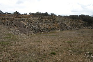
Cliffe Hill Quarry is a 19.2 hectares geological Site of Special Scientific Interest on the western outskirts of Markfield in Leicestershire. It is a Geological Conservation Review site.

Scaynes Hill is a 0.04-hectare (0.099-acre) geological Site of Special Scientific Interest north-west of Newick in East Sussex. It is a Geological Conservation Review site.

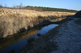
Shipton-on-Cherwell and Whitehill Farm Quarries is a 30-hectare (74-acre) geological Site of Special Scientific Interest north of Kidlington in Oxfordshire. It is a Geological Conservation Review site.
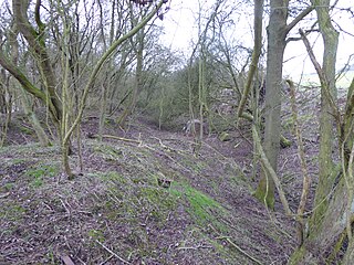
Hook Norton Cutting and Banks is a 6.7-hectare (17-acre) biological and geological Site of Special Scientific Interest south of Hook Norton in Oxfordshire. The site is in three areas, two of which are managed as a nature reserve called Hook Norton Cutting by Berkshire, Buckinghamshire and Oxfordshire Wildlife Trust. and are designated a Geological Conservation Review site.

Kirtlington Quarry is a 3.1-hectare (7.7-acre) geological Site of Special Scientific Interest west of Kirtlington in Oxfordshire. It is a Geological Conservation Review site, and it is part of the 7.4-hectare (18-acre) Kirtlington Quarry Local Nature Reserve.

Ardley Cutting and Quarry is a 40.1-hectare (99-acre) biological and geological Site of Special Scientific Interest north-west of Bicester in Oxfordshire. It is a Geological Conservation Review site and an area of 11 hectares is managed by the Berkshire, Buckinghamshire and Oxfordshire Wildlife Trust as Ardley Wood Quarry. The site contains a Scheduled Monument, Ardley Wood moated ringwork, a Norman defended enclosure.

Woodeaton Quarry is a 7.3-hectare (18-acre) geological Site of Special Scientific Interest north of Oxford in Oxfordshire. It is a Geological Conservation Review site.

Horsehay Quarries is a 8.4-hectare (21-acre) geological Site of Special Scientific Interest west of Bicester in Oxfordshire. It is a Geological Conservation Review site.

Lyehill Quarry is a 2.8-hectare (6.9-acre) geological Site of Special Scientific Interest east of Oxford in Oxfordshire. It is a Geological Conservation Review site.
