Shellman, Georgia | |
|---|---|
City | |
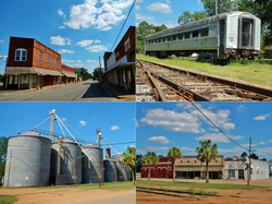 Shellman in 2012. | |
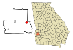 Location in Randolph County and the state of Georgia | |
| Coordinates: 31°45′31″N84°36′46″W / 31.75861°N 84.61278°W | |
| Country | United States |
| State | Georgia |
| County | Randolph |
| Area | |
• Total | 3.15 sq mi (8.16 km2) |
| • Land | 3.15 sq mi (8.16 km2) |
| • Water | 0 sq mi (0.00 km2) |
| Elevation | 384 ft (117 m) |
| Population (2020) | |
• Total | 861 |
| • Density | 273.4/sq mi (105.56/km2) |
| Time zone | UTC-5 (Eastern (EST)) |
| • Summer (DST) | UTC-4 (EDT) |
| ZIP codes | 39886 |
| Area code | 229 |
| FIPS code | 13-70120 [2] |
| GNIS feature ID | 0356533 [3] |
Shellman is a city in Randolph County, Georgia, United States. As of the 2020 census, Shellman had a population of 861. [4] Buildings in the commercial center have been designated as an historic district and listed in 1985 on the National Register of Historic Places.


