Sheridan commonly refers to:

Sheridan is a village in LaSalle County, Illinois, United States. As of the 2000 census, the village population was 2,411. It is part of the Ottawa–Streator Micropolitan Statistical Area.

Philip Henry Sheridan was a career United States Army officer and a Union general in the American Civil War. His career was noted for his rapid rise to major general and his close association with General-in-chief Ulysses S. Grant, who transferred Sheridan from command of an infantry division in the Western Theater to lead the Cavalry Corps of the Army of the Potomac in the East. In 1864, he defeated Confederate forces under General Jubal Early in the Shenandoah Valley and his destruction of the economic infrastructure of the Valley, called "The Burning" by residents, was one of the first uses of scorched earth tactics in the war. In 1865, his cavalry pursued Gen. Robert E. Lee and was instrumental in forcing his surrender at Appomattox.

Lake View, also spelled Lakeview, is one of the 77 community areas of Chicago, Illinois, located on the city's North Side. It is bordered by West Diversey Parkway on the south, West Irving Park Road on the north, North Ravenswood Avenue on the west, and the shore of Lake Michigan on the east. The Uptown community area is to Lakeview's north, Lincoln Square to its northwest, North Center to its west and Lincoln Park to its south. The 2016 population of Lakeview was 99,876 residents, making it the largest of the Chicago community areas by population.

Fort Sheridan in IL is a residential neighborhood spread among Lake Forest, Highwood, and Highland Park in Lake County, Illinois, United States. It was originally established as Fort Sheridan, a United States Army Post named after Civil War Cavalry General Philip Sheridan, to honor his services to Chicago.
Illinois Route 58 is a state highway in northeast Illinois. It runs from Illinois Route 25 in Elgin east to U.S. Route 41 in Skokie. This is a distance of 27.88 miles (44.87 km).
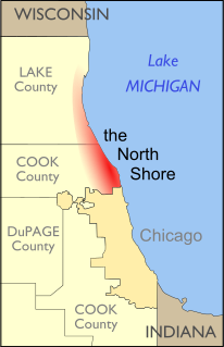
The North Shore consists of many affluent suburbs north of Chicago, Illinois, bordering the shores of Lake Michigan. These communities fall within suburban Cook County and Lake County. The North Shore's membership is often a topic of debate, and is sometimes expanded to include other affluent Chicago suburbs which do not border Lake Michigan. However, Evanston, Wilmette, Kenilworth, Winnetka, Glencoe, Highland Park, Lake Forest, and Lake Bluff are generally considered to be the main members of the North Shore, as all are affluent communities that border the lake just north of Chicago. Other suburbs such as Glenview, Northbrook, Deerfield, Vernon Hills, and Northfield are often considered to be a part of the North Shore, but do not border Lake Michigan. Northwestern University is also located in the Evanston area of North Shore Chicago.
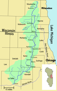
The Fox Valley—also commonly known as the Fox River Valley—is a region centered on the Fox River of Northern Illinois, along the western edges of the Chicago metropolitan area. The region extends from the village of Antioch in far northern Illinois, to the city of Ottawa in the south. It includes rural areas, suburban development, and 19th-century downtowns. Around 1 million people live in this area.
Illinois Route 137 is a state highway in northeast Illinois. It runs from the Wisconsin Border north of Winthrop Harbor south to North Chicago, west to Libertyville, and then back northwest to Grayslake, terminating at Illinois Route 83 just south of Illinois Route 120. This is a distance of 23.49 miles (37.80 km).
Sheridan Road is a major north-south street that leads from Diversey Parkway in Chicago, Illinois, north to the Illinois-Wisconsin border and beyond to Racine. Throughout most of its run, it is the easternmost north-south through street, closest to Lake Michigan. From Chicago, it passes through Chicago's wealthy lakeside North Shore suburbs, and then Waukegan and Zion, until it reaches the Illinois-Wisconsin state line in Winthrop Harbor. In Wisconsin, the road leads north through Pleasant Prairie and Kenosha, until it ends on the south side of Racine.

Mission Township is located in LaSalle County, Illinois. As of the 2010 census, its population was 3,972 and it contained 1,083 housing units.

Northville Township is located in LaSalle County, Illinois. As of the 2010 census, its population was 7,410 and it contained 3,143 housing units.
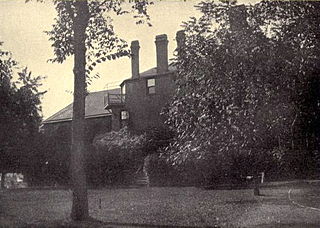
The Wayside, also known as the Henry Demarest Lloyd House, is a historic house at 830 Sheridan Road in Winnetka, Illinois, United States. An extensively altered mid-19th century country inn, it was from 1880 until his death in 1903 the principal residence of Henry Demarest Lloyd (1847–1903). Lloyd was a leading "muckraking" journalist of the late 19th century, and a major editorial voice against corporate monopolies and for organized labor. His house was declared a National Historic Landmark in 1966.
Norway is an unincorporated community in Mission Township, LaSalle County, Illinois. Located along the Fox River, the community was the site of an early Norwegian-American settlement. Today it is the site of the State of Illinois Norwegian Settlers Memorial.
Catharine, also known as Burgess Junction, is an unincorporated community in Serena Township, LaSalle County, Illinois, United States. Catharine is located along County Route 2, 2 miles (3.2 km) west of Sheridan.
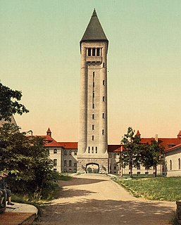
The Philip H. Sheridan Reserve Center is the former Fort Sheridan now in Lake Forest, Highwood, and Highland Park in Lake County, Illinois, United States. It was originally established as a United States Army Post named after Civil War Cavalry General Philip Sheridan, to honor his services to Chicago. When the main fort was officially closed by the Army on May 3, 1993, the majority of the property was sold by the Department of Defense to commercial land developers. Most of the original housing structures were then refurbished and resold as a residential community. Other buildings were given to cultural organizations like Midwest Young Artists, the largest youth music program in the Midwest. Approximately 90 acres of the southern end of the original post were retained by the Army; there the Army now operates the Sheridan Reserve Center complex.
The Sheridan Correctional Center is a medium-security state prison for men located in Sheridan, LaSalle County, Illinois, owned and operated by the Illinois Department of Corrections.

Leo John Sheridan was a Chicago real estate executive, and United States Ambassador to Ireland (1968–1969).
Edgecliff is a Samuel Abraham Marx–designed estate in Winnetka, Illinois, in the wealthiest region of Chicago's affluent North Shore suburbs. It is notable for once having the highest residential property taxes in Cook County, Illinois.


