Shidler, Oklahoma

Last updated

Shidler, Oklahoma
Shidler, OK 2003.jpg
Downtown Shidler, 2003
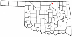
OKMap-doton-Shidler.PNG
Location of Shidler, Oklahoma
Coordinates: 36°46′50″N96°39′36″W / 36.78056°N 96.66000°W / 36.78056; -96.66000
Country United States
State Oklahoma
County Osage
Area
[1]
  Total0.75 sq mi (1.93 km2)
  Land0.75 sq mi (1.93 km2)
  Water0.00 sq mi (0.00 km2)
Elevation
[2]
1,161 ft (354 m)
Population
 (2020)
  Total328
  Density439.68/sq mi (169.71/km2)
Time zone UTC-6 (Central (CST))
  Summer (DST) UTC-5 (CDT)
ZIP code
74652
Area code(s) 539/918
FIPS code 40-67200 [3]
GNIS feature ID2411890 [2]

Shidler is a city in Osage County, Oklahoma, United States. The population was 328 in the 2020 census, a decline from the figure of 441 recorded in 2010. [4]

Contents

History

Shidler was founded in December 1921 and named for Eugene S. Shidler, a Pawhuska banker and rancher. The town grew rapidly to a population of approximately 5,000 due to the discovery of petroleum nearby (see Whizbang) and the arrival of the Osage Railway (one of the Muskogee Roads) in February 1922. In that year, Shidler had 19 oil-well supply businesses and six plants manufacturing gasoline. Shidler had a reputation for lawlessness, with bank and highway robberies common. By the late 1920s, the oil boom had subsided and Shidler began to lose population. Shidler's population in the 1930 census was 1,177 and the downward trend continued. Shidler today is a quiet farming and ranching community, although there is still some petroleum production in the area. [5]

During World War II, citizens of Shidler actively lobbied to prevent the internment of the Yamamoto family from Shidler (see Internment of Japanese Americans). Due to the efforts of U.S. Senator Elmer Thomas, the internment order was lifted. [6]

Geography

Shidler is located 29 miles (47 km) northwest of Pawhuska, the seat of Osage County. [5]

According to the United States Census Bureau, the city has a total area of 0.8 square miles (2.1 km2), all land.

Demographics

Historical population
CensusPop.Note
1930 1,177
1940 718−39.0%
1950 84017.0%
1960 8703.6%
1970 717−17.6%
1980 708−1.3%
1990 487−31.2%
2000 5206.8%
2010 441−15.2%
2020 328−25.6%
U.S. Decennial Census [7]

As of the census [3] of 2000, there were 520 people, 231 households, and 148 families residing in the city. The population density was 678.8 inhabitants per square mile (262.1/km2). There were 278 housing units at an average density of 362.9 per square mile (140.1/km2). The racial makeup of the city was 81.35% White, 14.04% Native American, 0.96% from other races, and 3.65% from two or more races. Hispanic or Latino of any race were 2.50% of the population.

There were 231 households, out of which 25.5% had children under the age of 18 living with them, 49.8% were married couples living together, 9.5% had a female householder with no husband present, and 35.9% were non-families. 31.6% of all households were made up of individuals, and 17.3% had someone living alone who was 65 years of age or older. The average household size was 2.25 and the average family size was 2.78.

In the city, the population was spread out, with 23.5% under the age of 18, 9.6% from 18 to 24, 22.5% from 25 to 44, 23.1% from 45 to 64, and 21.3% who were 65 years of age or older. The median age was 41 years. For every 100 females, there were 92.6 males. For every 100 females age 18 and over, there were 86.0 males.

The median income for a household in the city was $29,732, and the median income for a family was $35,156. Males had a median income of $31,932 versus $17,143 for females. The per capita income for the city was $16,245. About 11.0% of families and 15.9% of the population were below the poverty line, including 23.1% of those under age 18 and 13.5% of those age 65 or over.

Education

The town is home of the Shidler Public Schools [8] Fighting Tigers. The school has about 250 students in kindergarten through 12th grade. The school brings in students from the surrounding towns of Grainola, Foraker, Webb City, Kaw City, and part of Burbank.

Related Research Articles

<span class="mw-page-title-main">Washington County, Oklahoma</span> County in Oklahoma, United States

Washington County is a county located in the northeastern part of the U.S. state of Oklahoma. As of the 2020 census, the population was 52,455. Its county seat is Bartlesville. Named for President George Washington, it is the second smallest county in Oklahoma in total area, adjacent to the largest county in Oklahoma, Osage County.

<span class="mw-page-title-main">Osage County, Oklahoma</span> County in Oklahoma, United States

Osage County is the largest county by area in the U.S. state of Oklahoma. Created in 1907 when Oklahoma was admitted as a state, the county is named for and is home to the federally recognized Osage Nation. The county is coextensive with the Osage Nation Reservation, established by treaty in the 19th century when the Osage relocated there from Kansas. The county seat is in Pawhuska, one of the first three towns established in the county. The total population of the county as of 2020 was 45,818.

<span class="mw-page-title-main">Chetopa, Kansas</span> City in Labette County, Kansas

Chetopa is a city in Labette County, Kansas, United States. As of the 2020 census, the population of the city was 929. Chetopa was named for Chief Chetopah, an Osage Indian chief. Later, the community name was shortened.

<span class="mw-page-title-main">Lyndon, Kansas</span> City in Osage County, Kansas

Lyndon is a city in, and the county seat of Osage County, Kansas, United States. As of the 2020 census, the population of the city was 1,037.

<span class="mw-page-title-main">Osage City, Kansas</span> City in Osage County, Kansas

Osage City is a city in Osage County, Kansas, United States. As of the 2020 census, the population of the city was 2,861.

<span class="mw-page-title-main">Neodesha, Kansas</span> City in Wilson County, Kansas

Neodesha is a city in Wilson County, Kansas, United States. As of the 2020 census, the population of the city was 2,275. The name is derived from the Osage Indian word, Ni-o-sho-de, and is translated as The-Water-Is-Smoky-With-Mud.

<span class="mw-page-title-main">Kaw City, Oklahoma</span> City in Oklahoma, United States

Kaw City is a city in eastern Kay County, Oklahoma, United States. The population was 375 at the 2010 census, an increase of 1 percent from the figure of 372 in 2000. Kaw City was named for the Kanza Indians, called the Kaw by locals.

<span class="mw-page-title-main">Avant, Oklahoma</span> Town in Oklahoma, United States

Avant is an incorporated community in eastern Osage County, Oklahoma, United States. The population was 320 at the 2010 census, a decline of 14.0 percent from the figure of 372 recorded in 2000.

<span class="mw-page-title-main">Barnsdall, Oklahoma</span> City in Oklahoma, United States

Barnsdall is a city in Osage County, Oklahoma, United States. The population was 1,034 at the 2020 census, a decline of 21.9 percent from the figure of 1,325 recorded in 2000.

<span class="mw-page-title-main">Burbank, Oklahoma</span> Town in Oklahoma, United States

Burbank is a town in western Osage County, Oklahoma, United States. The population was 141 at the 2010 census, a 9 percent decrease from the figure of 155 recorded in 2000.

<span class="mw-page-title-main">Fairfax, Oklahoma</span> Town in Oklahoma, United States

Fairfax is a town in Osage County, Oklahoma, United States. The Osage Nation reservation is coterminous with the county. The population was 1,380 at the 2010 census, down 11.3 percent from the figure of 1,555 recorded in 2000. It was the home of the ballerinas Maria and Marjorie Tallchief.

<span class="mw-page-title-main">Foraker, Oklahoma</span> Town in Oklahoma, United States

Foraker is a ghost town in Osage County, Oklahoma, United States. It was named for Ohio Senator Joseph B. Foraker. The Tallgrass Prairie Preserve is southeast of town. The official population peaked at 415 in 1910 and has declined steadily since 1930. The population was only 18 at the 2010 census, a 21.7 percent decline from 23 in 2000.

<span class="mw-page-title-main">Grainola, Oklahoma</span> Town in Oklahoma, United States

Grainola is a town in northwest Osage County, Oklahoma, United States. The population was 31 at the 2010 census, a figure which was unchanged from 2000. The main industry of the area is cattle ranching. The town name was invented in March 1910.

<span class="mw-page-title-main">Hominy, Oklahoma</span> Town in Oklahoma, United States

Hominy is a city in Osage County, Oklahoma, United States. The population was 3,565 at the 2010 census, a 38 percent increase over the figure of 2,584 recorded in 2000.

<span class="mw-page-title-main">Osage, Oklahoma</span> Town in Oklahoma, United States

Osage is a town in Osage County, Oklahoma, United States. Also known as Osage City, it lies within the Osage Reservation on the shore of Lake Keystone. The population was 156 at the 2010 census, down 17 percent from the figure of 188 recorded in 2000.

<span class="mw-page-title-main">Pawhuska, Oklahoma</span> City in Oklahoma, United States

Pawhuska is a city in and the county seat of Osage County, Oklahoma, United States. As of the 2020 census, the population of the city was 2,984. It was named after the 19th-century Osage chief, Paw-Hiu-Skah, which means "White Hair" in English. The Osage tribal government, which opened offices in Pawhuska in 1872 when its reservation was established in Indian Territory, continues to be based in Pawhuska.

<span class="mw-page-title-main">Prue, Oklahoma</span> Town in Oklahoma, United States

Prue is a town in southern Osage County, Oklahoma, United States. The population was 465 at the 2010 census, up 7.4 percent from the figure of 433 recorded in 2000. The town was named for Henry Prue, who owned the original townsite. Prue was relocated when Lake Keystone was built, and is sometimes called "New Prue".

<span class="mw-page-title-main">Webb City, Oklahoma</span> Town in Oklahoma, United States

Webb City is an unincorporated town in northwestern Osage County, Oklahoma, United States. The population was 62 at the 2010 census, a 34.7 percent decline from the figure of 95 recorded in 2000. It was named for its founder, Horace Webb, on whose land the town was founded. The Webb City post office opened December 16, 1922.

<span class="mw-page-title-main">Cleveland, Oklahoma</span> City in Oklahoma, United States

Cleveland is a city in Pawnee County, Oklahoma, United States. The 2010 census population was 3,251, a decrease of 0.9 percent from the figure of 3,282 recorded in 2000.

<span class="mw-page-title-main">Ralston, Oklahoma</span> Town in Oklahoma, United States

Ralston is a town in Pawnee County, Oklahoma, United States. The town is southeast of Ponca City on State Highway 18 near the west bank of the Arkansas River. The population was 330 at the 2010 census, a decline of 7 percent from the figure of 355 recorded in 2000.

References

  1. "ArcGIS REST Services Directory". United States Census Bureau. Retrieved September 20, 2022.
  2. 1 2 U.S. Geological Survey Geographic Names Information System: Shidler, Oklahoma
  3. 1 2 "U.S. Census website". United States Census Bureau . Retrieved January 31, 2008.
  4. "Shidler City, Oklahoma". U.S. Bureau of the Census.
  5. 1 2 Jon D. May, "Shidler," Encyclopedia of Oklahoma History, Accessed 25 Feb 2011
  6. Jackson, Rachel C. "How it Should Be," Sugar Mule, Issue #35.
  7. "Census of Population and Housing". Census.gov. Retrieved June 4, 2015.
  8. "2020 CENSUS - SCHOOL DISTRICT REFERENCE MAP: Osage County, OK" (PDF). U.S. Census Bureau . Retrieved January 26, 2024.