
Shizuoka Prefecture is a prefecture of Japan located in the Chūbu region of Honshu. As of September 2023, Shizuoka Prefecture has a population of 3,555,818 and has a geographic area of 7,777.42 km2 (3,002.88 sq mi). Shizuoka Prefecture borders Kanagawa Prefecture to the east, Yamanashi Prefecture to the northeast, Nagano Prefecture to the north, and Aichi Prefecture to the west.

Shimoda is a city and port located in Shizuoka Prefecture, Japan. As of 1 February 2024, the city had an estimated population of 19,670 in 10,436 households, and a population density of 188 persons per square kilometre. The total area of the city is 104.71 square kilometres (40.43 sq mi). In the 1850s, Japan was in political crisis over its increasing inability to maintain its national seclusion policy and the issue of what relations, if any, it should have with foreign powers. For a few years, Shimoda was central to this debate.

Itō is a city located on the eastern shore of the Izu Peninsula in Shizuoka Prefecture, Japan. As of 1 August 2023, the city had an estimated population of 63,343 and a population density of 510 persons per km2. The total area was 124.13 square kilometres (47.93 sq mi).

Izu Province was a province of Japan in the area of Shizuoka Prefecture. Izu bordered on Sagami and Suruga Provinces. Its abbreviated form name was Zushū (豆州).

Fuji-Hakone-Izu National Park is a national park in Yamanashi, Shizuoka, and Kanagawa Prefectures, and western Tokyo Metropolis, Japan. It consists of Mount Fuji, Fuji Five Lakes, Hakone, the Izu Peninsula, and the Izu Islands. Fuji-Hakone-Izu National Park covers 1,227 square kilometres (474 sq mi).

The Izu peninsula is a large mountainous peninsula with a deeply indented coastline to the west of Tokyo on the Pacific coast of the island of Honshu, Japan. Formerly known as Izu Province, Izu peninsula is now a part of Shizuoka Prefecture. The peninsula has an area of 1,421.24 km2 (548.74 sq mi) and its estimated population in 2005 was 473,942 people. The peninsula’s populated areas are located primarily on the north and east.

The Izu Islands are a group of volcanic islands stretching south and east from the Izu Peninsula of Honshū, Japan. Administratively, they form two towns and six villages; all part of Tokyo Prefecture. The largest is Izu Ōshima, usually called simply Ōshima.

Nii-jima (新島) is a volcanic Japanese island administered by the Tokyo Metropolitan Government. It is one of the Izu Seven Islands, group of the seven northern islands of the Izu archipelago, and is located approximately 163 kilometres (101 mi) south of Tōkyō and 36 kilometres (22 mi) south of Shimoda Shizuoka Prefecture. The island is the larger inhabited component of the village of Niijima Village, Ōshima Subprefecture of Tokyo Metropolis, which also contains the neighboring island of Shikine-jima and the smaller, uninhabited Jinai-tō. Nii-jima is also within the boundaries of the Fuji-Hakone-Izu National Park.

Kōzu-shima (神津島) is a volcanic Japanese island in the Philippine Sea. The island is administered by Tōkyō and is located approximately 30 kilometres (19 mi) northwest of the Miyake-jima and 14 kilometres (8.7 mi) southwest of the Nii-jima. It is one of the Izu Seven Islands, a group of the seven northern islands of the Izu archipelago. Kōzushima is administratively part of Kōzushima Village, under Ōshima Subprefecture of Tokyo Metropolis. As of 2017, the island's population was 1,952. Kōzushima is within the boundaries of the Fuji-Hakone-Izu National Park.

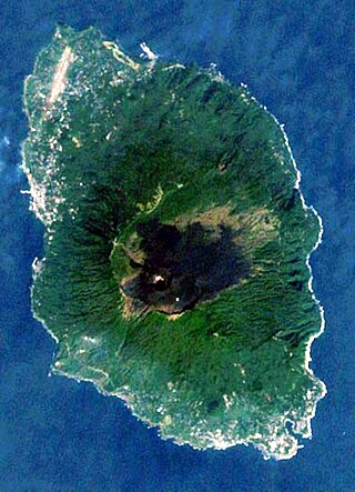
Miyake-jima is a volcanic island in the Izu archipelago in the Philippine Sea approximately 180 kilometers (110 mi) southeast of Tokyo, Japan. As with the other islands in the Izu Island group, Miyake-jima forms part of the Fuji-Hakone-Izu National Park.
Izu Ōshima is an inhabited volcanic island in the Izu archipelago in the Philippine Sea, off the coast of Honshu, Japan, 22 km (14 mi) east of the Izu Peninsula and 36 km (22 mi) southwest of Bōsō Peninsula. As with the other islands in the Izu Island group, Izu Ōshima forms part of the Fuji-Hakone-Izu National Park. Izu Ōshima, at 91.06 km2 (35.16 sq mi) is the largest and closest of Tokyo's outlying islands, which also include the Ogasawara Islands.

Toshima is a village located in Ōshima Subprefecture, Tokyo Metropolis, Japan. The village comprises the whole of To-shima Island.

Mikura-jima (御蔵島) is an inhabited volcanic Japanese island in the Pacific Ocean. The island is administered by Tōkyō Metropolis and is located approximately 200 kilometres (120 mi) south of Tokyo and 19 kilometres (12 mi) south-southeast of Miyake-shima. It is one of the Izu Seven Islands group of the seven northern islands of the Izu archipelago. Mikurashima is administratively part of Mikurashima Village under Miyake Subprefecture of Tokyo Metropolis. As of 2009, the island's population was 351. Mikura-shima is also within the boundaries of the Fuji-Hakone-Izu National Park.

Miyake is a village located in Miyake Subprefecture, Tokyo Metropolis, Japan. As of 1 October 2020, the village had an estimated population of 2,273, and a population density of 41.1 persons per km2. Its total area is 55.27 square kilometres (21.34 sq mi).

Hachijō is a town located in Hachijō Subprefecture, Tokyo Metropolis, Japan. As of 1 December 2022, the town had an estimated population of 7,056, and a population density of 97.7 persons per km2. Its total area is 72.24 square kilometres (27.89 sq mi). Electric power for the town is provided by a geothermal power station and by a wind farm.

Kōzushima Village is a village located in Ōshima Subprefecture, Tokyo Metropolis, Japan. As of 1 June 2022, the village had an estimated population of 1,841, and a population density of 99 persons per km2. Its total area is 18.58 square kilometres (7.17 sq mi).

Mikurajima Village is a village located in Miyake Subprefecture, Tokyo Metropolis, Japan. As of 1 October 2020, the village had an estimated population of 323, and a population density of 11.7 persons per km2. Its total area is 20.54 square kilometres (7.93 sq mi).
Niijima is a village located in Ōshima Subprefecture, Tokyo Metropolis, Japan. As of 1 October 2020, the village had an estimated population of 2,441, and a population density of 88.6 persons per km2. Its total area is 27.54 square kilometres (10.63 sq mi).

Tōkai Kisen is a shipping company headquartered in 1-16-1, Kaigan, Minato, Tokyo, Japan (〒105-6891 東京都港区海岸一丁目16番1号). Its main business is freight and passenger transportation between the main island of Honshu and the Izu Islands in the Pacific Ocean. The company is listed on the Second Floor of the Tokyo Stock Exchange.
The Seven Islands of Izu are the seven inhabited islands of the Izu Islands that belong to the Tokyo Islands of Tokyo Prefecture, Japan.


