
Mitrovica, also referred to as South Mitrovica, is a city in northern Kosovo and administrative center of the District of Mitrovica. In 2013, the city was split into two municipalities, South Mitrovica and North Mitrovica. Settled 10 km (6.2 mi) from Ujmani/Gazivoda Lake, on the confluence of the rivers Ibër, Sitnicë, Lushta, and Trepça, the city is surrounded by the mountains of Kopaonik, Rogozna, Mokna, and Çyçavica. According to the 2011 Census, the two municipalities had 97,686 inhabitants of which 85,360 reside in south and 12,326 in north.
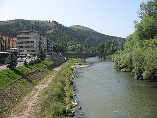
The Ibar, also known as the Ibër and Ibri, is a river that flows through eastern Montenegro, northern Kosovo and central Serbia, with a total length of 272 km (169 mi). The river begins in the Hajla mountain, in Rožaje, eastern Montenegro, and passes through southwestern Serbia and northern Kosovo, where it leads back into Serbia to flow into the West Morava river near Kraljevo, central Serbia.
The Llap Region is a region located in the north-eastern part of Kosovo. Llap in the broadest sense includes the watershed of the Llapi River. The Llapi water collection begins in the mountains of Kopaonik in the north and west and its source is considered to be the village of Pollatë, and ends by joining the Sitnica river in Lumadh, municipality of Vushtrri, in the north-west of Pristina. The topographic watershed of the Llapi River covers an area of 945.4 km2 (365.0 sq mi).

The Great Morava is the final section of the Morava, a major river system in Serbia.

The District of Ferizaj is one of the seven districts of Kosovo. Ferizaj is the seat of the district. According to the 2024 census, the total population of the district is 180,897.

Vushtrri is a city and municipality located in the Mitrovica District in Kosovo. According to the 2011 census, the town of Vushtrri has 26,964 inhabitants, while the municipality has 69,870 inhabitants. Vushtrri is surrounded by the city of Mitrovica to the north, Podujevë in the east, Obiliq in the south, Drenas in the south-west, and Skenderaj in the west. The municipality of Vushtrri has 67 villages.
Obiliq is a town and municipality in Kosovo. According to the Kosovo Agency of Statistics (KAS) estimate from the 2011 census, there were 21,549 people residing in Obiliq Municipality, with Kosovo Albanians constituting the majority of the population.

Drenica, also known as the Drenica Valley, is a hilly region in central Kosovo, covering roughly around 700 square kilometres (270 sq mi) of Kosovo's total area (6%). It consists of two municipalities, Drenas and Skenderaj, and several villages in Klina, Zubin Potok, Mitrovica and Vushtrri. It is located west of the capital, Pristina.

The Jablanica is an 85-kilometre-long (53 mi) river in southern Serbia. A left tributary of the South Morava river, it gives its name to the region of Jablanica and to modern Serbia's Jablanica District, with the region contributing about one third of the district's area.

The Lepenac is a river in southern Kosovo and northern North Macedonia, a 75 km (47 mi) long left tributary to the Vardar river.

The Llapi River is a river in the north-eastern part of Kosovo. The 72 km (45 mi) long right tributary to the Sitnica river, it is the main river in the Llap (region) depression.
The Klina is a river in Kosovo, a 62 km (39 mi) long left tributary to the White Drin. It flows entirely within Kosovo.

The Drenica is a river in Kosovo, a 50 km (31 mi) long left tributary to the Sitnica river. It flows entirely within Kosovo and gives its name to the surrounding Drenica region.
Carraleva is a mountain in central Kosovo, dividing its two main geographical regions, the Kosovo Plain and Metohija. Carraleva is also a point where all three drainage basins of Kosovo meet, making the mountain a major hydrographic knot. It is named after the village of Carraleva.

The Nerodime is a river in the Nerodime region of Kosovo, a 41 km (25 mi) long left tributary to the Lepenc river. It represents Europe's only instance of a river bifurcation flowing into two seas, dividing into two irreversible branches. The left branch flows into the Black Sea, and the right branch flows into the Aegean Sea.

Kosovo is a landlocked country in Southeastern Europe. The country is strategically positioned in the center of the Balkan Peninsula enclosed by Montenegro to the west, Serbia to the north and east, North Macedonia to the southeast, and Albania to the southwest. It has no direct access to the Mediterranean Sea but its rivers flow into three seas, the Adriatic, Aegean and Black Sea.

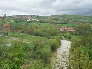
Čičavica or Çyçavica is a mountain situated at the center of Kosovo with a length of about 8 km (5 mi) and a width of about 5 km (3 mi). Its highest peak reaches to a height of 1,091 m (3,579 ft). It is in the boundary line between the Drenica region and the Kosovo Plain. The river Sitnica passes close by it. The village of Stanoc i Poshtëm is located to the right of the mountain. Large towns and cities like Pristina, Vushtrri, Obiliq and Mitrovica are located close by the mountain.

Stanoc i Poshtëm is a village in Vushtrri municipality, in Kosovo. It is located near the city of Vushtrri in the Mitrovica District of northeastern Kosovo. Together with the Upper Stanovc they made Stanoc, as a biggest villages in Kosovo. Stanovc is situated between the river Sitnica and the Pristina-Mitrovica road. It is approximately 15 km (9 mi) from the Pristina.
Natural resources are abundant in Kosovo. Kosovo is mainly rich in lignite and mineral resources such as: coal, zinc, lead, silver and chromium, but also with productive agricultural land. Kosovo is also rich in forests, rivers, mountains and soil; Kosovo is especially rich in coal, being aligned among European countries as the third with the largest coal reserves. Kosovo possesses around 14,700 billion tons of lignite in reserves, which aligns Kosovo as the country with the fifth largest lignite reserves in the world.

Mitrovica District is one of the seven districts of Kosovo. Its administrative center and the largest city is Mitrovica. The district borders on the District of Peja to the south-west, the District of Pristina to the south and east, and the Serbia to the north and northwest.


