
Joseph Ellis Johnson was a farmer, businessman and politician who served as United States Representative and became the 32nd Governor of Virginia from 1852 to 1856, the first Virginia governor to be popularly elected as well as the only Virginia governor from west of the Appalachian mountains. During the American Civil War, he sympathized with the Confederacy, but returned to what had become West Virginia for his final years.
U.S. Route 258 is a spur of US 58 in the U.S. states of North Carolina and Virginia. The U.S. Highway runs 220.15 miles (354.30 km) from US 17 Business and NC 24 Business in Jacksonville, North Carolina north to Virginia State Route 143 at Fort Monroe in Hampton, Virginia. In North Carolina, US 258 connects Jacksonville with the Inner Banks communities of Kinston, Snow Hill, Farmville, Tarboro, and Murfreesboro. The U.S. Highway continues through the Virginia city of Franklin, where the highway intersects US 58, and the town of Smithfield on its way to the Hampton Roads metropolitan area. US 258 crosses the James River on the James River Bridge and follows Mercury Boulevard through Newport News and Hampton.

The Jamestown Ferry is a free automobile and bus ferry service across a navigable portion of the James River in Virginia. It carries State Route 31, connecting Jamestown in James City County with Scotland Wharf in Surry County.
The Northwestern Turnpike is a historic road in West Virginia, important for being historically one of the major roads crossing the Appalachians, financed by the Virginia Board of Public Works in the 1830s. In modern times, west of Winchester, Virginia, U.S. Route 50 follows the path of the Northwestern Turnpike into West Virginia, whose major Corridor D project follows the western section of the original Northwestern Turnpike.

The Waterloo–Reading line is a National Rail electric railway line between London Waterloo and Reading. The line runs west through a series of South West London suburbs to Reading, in central Berkshire. Its passenger operation is by South Western Railway (SWR), which also manage its stations.

The National Register of Historic Places in the United States is a register including buildings, sites, structures, districts, and objects. The Register automatically includes all National Historic Landmarks as well as all historic areas administered by the U.S. National Park Service. Since its introduction in 1966, more than 90,000 separate listings have been added to the register.

West Virginia Route 28 is a north–south route through the Potomac Highlands of the U.S. state of West Virginia. The southern terminus of the route is at West Virginia Route 39 in Huntersville. The northern terminus is at the Maryland state line in Wiley Ford, where the route continues into Cumberland as Canal Parkway upon crossing the North Branch Potomac River.
The Potomac Highlands of West Virginia centers on five West Virginian counties in the upper Potomac River watershed in the western portion of the state's Eastern Panhandle, bordering Maryland and Virginia. Because of geographical proximity, similar topography and landscapes, and shared culture and history, the Potomac Highlands region also includes Pocahontas, Randolph, and Tucker counties, even though they are in the Monongahela River or New River watersheds and not that of the Potomac River.

The Parkersburg Bridge crosses the Ohio River between Parkersburg, West Virginia, and Belpre, Ohio. Designed by Jacob Linville, the bridge has 46 spans: 25 deck plate girder, 14 deck truss, 6 through truss, and 1 through plate girder. 50,000 cubic yards (38,000 m3) of stone were used for the 53 piers. The bridge was constructed from May 1869 to January 1871 by the Baltimore and Ohio Railroad. At the time of its completion, the bridge was reportedly the longest in the world at 7,140 feet (2,180 m).
Interstate 64 (I-64) is an Interstate Highway in the U.S. state of West Virginia. It travels through the state for 184 miles (296 km) passing by the major towns and cities of Huntington, Charleston, Beckley, and Lewisburg.
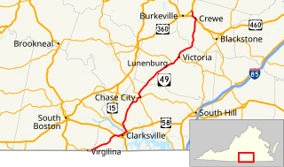
State Route 49 is a primary state highway in the U.S. state of Virginia. The state highway runs 69.01 miles (111.06 km) from the North Carolina state line in Virgilina, Virginia in Halifax County, where the highway continues south as North Carolina Highway 49, north to U.S. Route 360 near Burkeville in Nottoway County. SR 49 passes through Southside Virginia, connecting Virgilina and Burkeville with Clarksville and Chase City in Mecklenburg County, Victoria in Lunenburg County, and Crewe in Nottoway County. Via US 360, the state highway connects Richmond with the John H. Kerr Reservoir.
U.S. Route 60 (US 60) in the Commonwealth of Virginia runs 303 miles (488 km) west to east through the central part of the state, generally close to and paralleling the Interstate 64 corridor, except for the crossing of the Blue Ridge Mountains, and in the South Hampton Roads area.

The Great Indian Warpath (GIW)—also known as the Great Indian War and Trading Path, or the Seneca Trail—was that part of the network of trails in eastern North America developed and used by Native Americans which ran through the Great Appalachian Valley. The system of footpaths extended from what is now upper New York to deep within Alabama. Various Indians traded and made war along the trails, including the Catawba, numerous Algonquian tribes, the Cherokee, and the Iroquois Confederacy. The British traders' name for the route was derived from combining its name among the northeastern Algonquian tribes, Mishimayagat or "Great Trail", with that of the Shawnee and Delaware, Athawominee or "Path where they go armed".
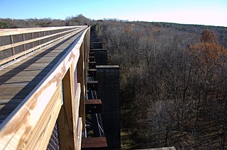
High Bridge Trail State Park is a rail trail in Southside Virginia converted from a rail line last belonging to Norfolk Southern.

Eugene Cyril "Geno" Smith III is an American football quarterback for the Seattle Seahawks of the National Football League (NFL). He played college football at West Virginia, leading the Mountaineers to multiple Bowl games, breaking numerous passing records and garnering multiple awards before getting drafted by the New York Jets in the second round of the 2013 NFL Draft. After two inconsistent seasons as the Jets' starting quarterback, Smith eventually lost his starting position due to injuries in his final two years with the team. He has also spent time as the backup for the New York Giants and Los Angeles Chargers, becoming the first African American quarterback to start for the former.
Julian Smith is an American author and journalist. He wrote Crossing the Heart of Africa, published in 2010 by Harper Perennial, and co-authored Smokejumper: A Memoir by One of America's Most Select Airborne Firefighters, published in 2015 by William Morrow. Smith and David Wolman are also co-authors of Aloha Rodeo: Three Hawaiian Cowboys, the World's Greatest Rodeo, and a Hidden History of the American West, coming May 28, 2019 from William Morrow.

A ford is a shallow place with good footing where a river or stream may be crossed by wading, or inside a vehicle getting its wheels wet. A ford may occur naturally or be constructed. Fords may be impassable during high water. A low water crossing is a low bridge that allows crossing over a river or stream when water is low but may be covered by deep water when the river is high.

Walkers Crossing was an unincorporated community in Wood County, West Virginia.


