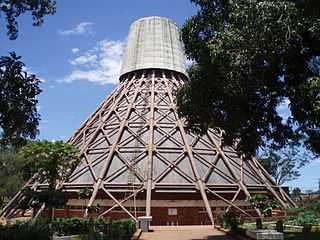
Namilyango College is a boys-only boarding middle and high school located in Mukono District in the Central Region of Uganda, whose history and excellence in sports and academics have made it one of the most prestigious schools in Uganda. It is Uganda's oldest secondary school, founded in 1902 by the Catholic Mill Hill Fathers.
Kira Town, a municipality in the Wakiso District of the Central Region of Uganda, is the country's second-largest city by population. It is administered by the Kira Town Council, an urban local government.

Mukono Town is a municipality in Mukono District in the Central Region of Uganda. The town is administered by the Mukono Town Council. The district headquarters are located in this town.
Namugongo is a township in the Central Region of Uganda.
The Kampala–Jinja Highway is a road in Uganda, connecting the cities of Kampala and Jinja. Sometimes referred to as Kampala–Jinja Road, it is a busy road, with several towns, trading centers and other points of interest along the way. As of October 2016, a new, wider, four-lane dual carriageway expressway, the Kampala–Jinja Expressway, is proposed to be constructed south of the present highway to relieve traffic and complement existing transport infrastructure between Kampala and Jinja.
Munyonyo is an area on the northern shores of Lake Victoria and part of the metropolitan area of Kampala, in Makindye Division.
Namilyango is a hill in Mukono District in south-central Uganda. The hill rises 1,220 metres (4,000 ft) above sea level. The name "Namilyango" is also applied to the village that occupies the hill and the schools and churches that are located there.
Nsasa is a neighborhood in Kira Municipality, Kyaddondo County, Wakiso District, in the Central Region of Uganda.
Naalya is a township in Kira Municipality, in Kyaddondo County, Wakiso District, in Uganda.
Opportunity Bank Uganda Limited (OBUL), is a commercial bank in Uganda. It received a commercial banking licence from the Bank of Uganda on 25 September 2019.
FINCA Uganda Limited, also known as FINCA Uganda, is a microfinance deposit-accepting institution (MDI) in Uganda. It is licensed and regulated by the Bank of Uganda, the central bank and national banking regulator.

Namanve is an area in the Central Region of Uganda. The larger portion of Namanve lies in Kira Municipality, in Wakiso District with portions located in Mukono Municipality, in Mukono District.
Seeta, sometimes wrongly spelled as Seta, is a township in Uganda.
John Chrysestom Muyingo is a Ugandan educator and politician. He is the State Minister for Higher Education in the Ugandan Cabinet. He was appointed to that position on 6 June 2016. He previously served as the State Minister for Primary Education from 1 March 2015 until 5 June 2016. Before that, from 27 May 2011 until 1 March 2015, he served as the State Minister for Higher Education, having replaced Mwesigwa Rukutana in May 2011. Muyingo was also the elected Member of Parliament for Bamunanika County, Luweero District. In the 2021 general elections he lost the seat to his former campaign manager and personal assistant, Robert Ssekitoleko who run on the National Unity Platform party ticket.
Kyaliwajjala is a neighborhood in Kira Municipality, Kyaddondo County, Wakiso District, in Central Uganda.
The Kampala Outer Beltway, also known as the Kampala Outer Ring Road, is a planned road in Uganda. It will form a full circle around Kampala, Uganda's capital and largest city.
Letshego Microfinance Uganda,, whose official name is Letshego Uganda Limited, is a Tier IV microfinance institution in Uganda.
Mbalwa is a neighborhood in Kyaliwajjala Parish, Kira Municipality, Wakiso District in the Central Region of Uganda.
Katosi Water Works (KWW), also Katosi Water Treatment Plant is a water purification and distribution project in Uganda.
Mulawa is a neighborhood in Kira Municipality, Kyaddondo County, Wakiso District, in Central Uganda.


