Namanve

Last updated
Flooded road at Namanve Industrial Park (March 2020) Flooded road Uganda.jpg
Flooded road at Namanve Industrial Park (March 2020)
Namanve
Uganda location map.svg
Red pog.svg
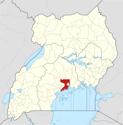
Namanve
Location in Uganda
Coordinates: 00°21′27″N32°41′39″E / 0.35750°N 32.69417°E / 0.35750; 32.69417
Country Flag of Uganda.svg Uganda
District Wakiso District
City Kira, Uganda
County Kyaddondo
Constituency Kyaddondo East
Government
   MP Ibrahim Semujju Nganda
Elevation
3,870 ft (1,180 m)

Namanve is an area in the Central Region of Uganda. The larger portion of Namanve lies in Kira Municipality, in Wakiso District with portions located in Mukono Municipality, in Mukono District. [1]

Contents

Location

Namanve lies in Bweyogerere Ward, in southeastern Kira Municipality, in Wakiso District, Central Uganda. It is located approximately 14 kilometres (9 mi), by road, east of downtown Kampala, Uganda's capital and largest city. [2] Namanve is bordered by Seeta to the east, Namilyango to the southeast, Lake Victoria to the south, Kirinnya to the southwest and Bweyogerere to the west and northwest. Portions of Namanve lie within the boundaries of Mukono Town Council. The geographical coordinates of Namanve are:0°21'27.0"N, 32°41'39.0"E (Latitude:0.357500; Longitude:32.694167). [3]

Points of interest

Train to Namanve leaving Kampala Railway Station A train at the Kampala Railway Station - Lyndah Katusiime.jpg
Train to Namanve leaving Kampala Railway Station

The following points of interest are in Namanve or close to its borders:

1. The Kampala-Jinja Highway passes through Namanve in an east-west direction, dividing it into North Namanve and South Namanve.

2. Kampala Industrial and Business Park is a 2,209 acres (894ha/8.9sqkm) development to house factories and other industries, located in South Namanve.

3. Namanve Coca-Cola Bottling Plant is one of the two bottling plants in Uganda owned by Coca-Cola International, in North Namanve

4. Namanve Power Station is owned by Jacobsen Electro. The 50 MW thermal power station is located north of the Kampala Industrial and Business Park, in a neighborhood known as Kiwanga. [4]

5. Rwenzori Mineral Water Bottling Company is located in neighboring Seeta, Uganda

6. Red Pepper Publishing Company: Their printing press is in neighboring Seeta, Uganda

7. Namanve Forest Reserve: Most of the reserve has been demolished to pave way for Kampala Business and Industrial Park: [5]

8. Namanve Railway Station is on the Uganda Railways System, administered by Rift Valley Railways. [6] [7]

See also

Related Research Articles

Mukono District District in Uganda

Mukono is one of the districts in the Central Region of Uganda. The town of Mukono home to the district's main commercial center and district headquarters.

Wakiso District District in Uganda

Wakiso District is a district in the Central Region of Uganda that partly encircles Kampala, Uganda's capital city. The town of Wakiso is the site of the district headquarters. Kira, the country's second largest city and suburb of Kampala, is in the district.

Mandela National Stadium

The Mandela National Stadium is a multi-purpose stadium in Uganda. It is named after the South African then-President and anti-apartheid icon, Nelson Mandela. The stadium's record attendance of 50,000 was set in 2004, in a football match between the national football teams of Uganda and South Africa.

Kira Town Place in Central Region, Uganda

Kira Town, a municipality in the Wakiso District of the Central Region of Uganda, is the country's second-largest city by population. It is administered by the Kira Town Council, an urban local government.

Mukono Town Urban centre in Uganda

Mukono Town is a municipality in Mukono District in the Central Region of Uganda. The town is administered by the Mukono Town Council. The district headquarters are located in this town.

The Kampala–Jinja Highway is a road in Uganda, connecting the cities of Kampala and Jinja. Sometimes referred to as Kampala–Jinja Road, it is a busy road, with several towns, trading centers and other points of interest along the way. As of October 2016, a new, wider, four-lane dual carriageway expressway, the Kampala–Jinja Expressway, is proposed to be constructed south of the present highway to relieve traffic and complement existing transport infrastructure between Kampala and Jinja.

Bweyogerere Place in Wakiso District, Uganda

Bweyogerere is one of the six townships or wards that constitute Kira Municipality in Wakiso District in southern central Uganda. The other five wards are Kimwaanyi, Kira, Kireka, Kirinnya and Kyaliwajjala.

Kireka Place in Wakiso District, Uganda

Kireka is the name of a township in Central Uganda. It is one of the six townships or Wards that constitute Kira Municipality in Wakiso District. The other five Wards in Kira Municipality are Bweyogerere Ward, Kimwaanyi Ward, Kira Ward, Kirinnya Ward and Kyaliwajjala Ward.

Gayaza Place in Central Region, Uganda

Gayaza is a town in Wakiso District in the Buganda Region of Uganda.

Nsasa Place in Central Region, Uganda

Nsasa is a neighborhood in Kira Municipality, Kyaddondo County, Wakiso District, in the Central Region of Uganda.

Namanve Power Station is a 50 MW heavy fuel oil-fired thermal power plant in Uganda. Sometimes the power station is referred to as Kiwanga Power Station.

Seeta, Uganda Place in Mukono District, Uganda

Seeta, sometimes wrongly spelled as Seta, is a township in Uganda.

Kampala Industrial and Business Park Place in Wakiso District

The Kampala Industrial and Business Park(KIBP), also referred to as Kampala Business and Industrial Park or Kampala Industrial Park, is an industrial and business park in Uganda. The park was developed by the Uganda Investment Authority (UIA) as a central place where investors can locate factories, warehouses, distribution centers, and other business offices.

Kyaliwajjala Place in Central Uganda, Uganda

Kyaliwajjala is a neighborhood in Kira Municipality, Kyaddondo County, Wakiso District, in Central Uganda.

Kirinnya Neighborhood in Kira Town, Uganda

Kirinnya, is one of the six administrative wards in Kira Municipality in Wakiso District in the Central Region of Uganda.

Kitikifumba Place in Central Region, Uganda

Kitikifumba is a neighborhood in Kira Municipality, Kyaddondo County, Wakiso District, in the Central Region of Uganda.

Kitukutwe Place in Central Uganda, Uganda

Kitukutwe is a neighborhood in Kira Municipality, Kyaddondo County, Wakiso District, in Central Uganda.

Kimwanyi Place in Wakiso District, Uganda

Kimwanyi is a neighborhood in Kira Municipality, Wakiso District, in the Buganda Region of Uganda. Kimwanyi also refers to Kimwanyi Parish, in Kira sub-county, Kyaddondo County, Wakiso District. It is one of the six parishes (wards) of Kira Municicipality, namely; Kimwanyi, Kira, Kyaliwajjala, Kireka, Bweyogerere and Kirinnya.

Sonde, Uganda Place in Mukono District, Uganda

Sonde, also Ssonde, is a settlement in Mukono District, in Uganda's Central Region.

Kijabijo Place in Buganda, Uganda

Kijabijo is a neighborhood in Kira Town, in Wakiso District in the Buganda Region of Uganda.

References

  1. Google (14 August 2021). "Map Showing Namanve, Uganda And Neighboring Locations" (Map). Google Maps . Google. Retrieved 14 August 2021.
  2. Google (14 August 2021). "Road Distance Between Kampala Road, Kampala City And Namanve, Uganda" (Map). Google Maps . Google. Retrieved 14 August 2021.
  3. Google (14 August 2021). "Location of Namanve, Central Region, Uganda" (Map). Google Maps . Google. Retrieved 14 August 2021.
  4. Juuko, Sylvia (6 November 2008). "Namanve Plant Reduces Load-Shedding". New Vision (Kampala). Archived from the original on 14 September 2012. Retrieved 23 January 2013.
  5. Kazoora, Cornelius (2001). "Conflict Resolution In The Namanve Peri-Urban Reforestation Project In Uganda" (PDF). Food and Agriculture Organization (FAO). Retrieved 23 January 2015.
  6. Malaba, Tom (23 July 2011). "Rift Valley Railways To Resume Passenger Train Services". Uganda Radio Network (URN). Retrieved 23 January 2015.
  7. Kyambadde, Savio (12 March 2012). "Rift Valley Railways To Resume Passenger Services In Kampala". Uganda Dispatch. Retrieved 23 January 2015.

Coordinates: 00°21′27″N32°41′39″E / 0.35750°N 32.69417°E / 0.35750; 32.69417