Matugga

Last updated

Matugga
Matugga Town Skyline.jpg
Matugga
Uganda location map.svg
Red pog.svg
Matugga
Map of Uganda showing the location of Matugga.
Coordinates: 00°27′37″N32°31′43″E / 0.46028°N 32.52861°E / 0.46028; 32.52861
CountryFlag of Uganda.svg  Uganda
Region Central Region
District Wakiso District
County Kyaddondo
Constituency Kyaddondo North
Population
 (2010 Estimate)
  Total15,000
Time zone UTC+3 (EAT)
Matugga Hill Matugga Hill.jpg
Matugga Hill
Bombo road in Matugga - Mabanda (Wakiso District) Matugga Town - Mabanda.jpg
Bombo road in Matugga - Mabanda (Wakiso District)

Matugga is an urban centre in the Central Region of Uganda. The town is a rapidly developing residential neighborhood in Gombe division of Nansana municipality in Wakiso District. [1]

Contents

Location

The town located in Matugga sub-county, Kyaddondo County, in Wakiso District. The area is surrounded by Kabunza, Kilyowa, Nasse, and Sanga sub–counties. It is situated on the tarmacked, all-weather Kampala–Gulu Highway. Matugga is located approximately 20 kilometres (12 mi), by road, north of Kampala, Uganda's capital and largest city. [2] The geographical coordinates of the town are 0°27'37.0"N, 32°31'43.0"E (Latitude:0.460278; Longitude:32.528611). [3]

Overview

Matugga is the starting point of the Matugga-Kapeeka Road, a 42 kilometres (26 mi) tarmacked road connecting the towns of Matugga, Gombe, Semuto, and Kapeeka. The highway traverses Wakiso District and Nakaseke District. The road was upgraded from gravel to bitumen in 2010 at an estimated cost of US$20 million. Sixty-five percent of the funding was provided by the government of Uganda, while 35 percent was provided by the Nordic Development Fund. [4] [5]

The name Matugga was adopted from Fredrick Matugga who had a house on a hill in the town in the 1980s. When he died, the hill was named after him. [6]

Population

In 2010, the town's population was estimated at 15,000, of whom about 60 percent were children below 18 years. [7]

Points of interest

The following points of interest are within the town limits or close to the edges of town: [3]

1. Offices of Matugga Town Council

2. Matugga Central Market

3. Busaawa-Mmanze Health Centre, a community health center administered by MACERUDET, a local NGO [8] 4. Revival Life Center, a complex with a 450-pupil primary school, a 200-pupil secondary school, and a 150-pupil orphanage administered by Pastor Ivan Lugoloobi of Revival Ministries, a Pentecostal Church [9]

5. Catholic Centre, a Catholic Church centre with St. Charles Lwanga Primary School administered by the Franciscan order of Greyfriars [10] 6. Ladybird School, an 80-pupil elementary boarding school affiliated with the Ingleton Middle School in Ingleton, North Yorkshire, United Kingdom

7. Life in the Word Church, in Lwadda A cell, a pentecoatal Church, founded and led by Rev. Isaac Mugabi, a No Place Left Practitioner and movement trainer who has initiated several movements in Uganda.

Prominent people

See also

Related Research Articles

Kasangati is a town in Nangabo sub-county, Wakiso District in the Central Region of Uganda. It also serves as the headquarters for Kyadondo County. The town is multi-lingual and is a "melting pot" of diverse cultures.

Nansana is a town in the Central Region of Uganda. It is located in the Wakiso District and is one of the five municipalities in the district. Nansana is a municipal council comprising four Divisions; Nansana Division, Nabweru Division, Gombe Division, and Busukuma Divisions. The four Divisions are considered as lower local government independent units.

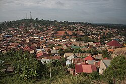
Gombe, is a small town in Wakiso District in the Central Region of Uganda.

Semuto is a town in the Central Region of Uganda. It is one of the urban centers in Nakaseke District.

Kapeeka is a town in Nakaseke District of the Central Region of Uganda.

Nsangi is a town in the Central Region of Uganda. It is one of the urban centers in Wakiso District.

Matugga–Kapeeka Road is a road in central Uganda, connecting the towns of Matugga in Wakiso District and Kapeeka in Nakaseke District.

Ngoma is a small town in Nakaseke District, Central Uganda. It is one of the municipalities within Nakaseke District. Other municipalities in the district include: (a) Butalangu (b) Kapeeka (c) Nakaseke (d) Semuto and (e) Wakyaato.

Gayaza is a town in Wakiso District in the Buganda Region of Uganda.

<span class="mw-page-title-main">Kajjansi</span> Place in Central Uganda, Uganda

Kajjansi is a town in Central Uganda. It is one of the urban centers in Wakiso District.

Gombe, Butambala, often referred to simply as Gombe, is a municipality in Butambala District in the Central Region of Uganda. It is the main municipal, administrative, and commercial center of the district and the site of the district headquarters.

Kanoni, also Kanoni, Gomba or Kanoni–Gomba, is a town in the Central Region of Uganda. It is the commercial, administrative, and political headquarters of Gomba District.

Kyengera is a town in the Central Region of Uganda. It is one of the urban centers in Wakiso District.

Kyaliwajjala is a neighborhood in Kira Municipality, Kyaddondo County, Wakiso District, in Central Uganda.

Buloba is an urban area in Wakiso District in the Buganda Region of Uganda. The area is primarily a middle-class residential neighborhood.

Namayumba is a settlement in the Wakiso District in the Buganda Region of Uganda. The name also refers to "Namayumba sub-county", the location of Namayumba settlement.

Maya is a town in the Central Region of Uganda. It is one of the urban centers in Wakiso District.

The Tondeka Metropolitan Kampala Bus Service (TMBS), is the proposed principal public transport operator in the Kampala metropolitan area. Expected to start in September 2020, the bus system, Tondeka Metro, proposes to serve the city of Kampala, Uganda's capital, the city of Entebbe, including Entebbe International Airport, Buloba, Nsangi, Ssabagabo, Mukono, Kira Town, Matugga, Wakiso, and the areas in Mukono District and Wakiso District that connect with these urban centers.

Nkumba is an urban area in Wakiso District in the Buganda Region of Uganda. The area is primarily a university town, on account of Nkumba University, a private university that maintains its main campus in the neighborhood.

The Kyaliwajjala–Kira–Kasangati–Matugga Road, also Kyaliwajjala–Matugga Road or Kira–Matugga Road, is a road in the Central Region of Uganda, connecting the neighborhood of Kyaliwajjala, in Kira Municipality in Wakiso District, to the town of Matugga, also in Wakiso District. This road is part of the 101 kilometres (63 mi) Kampala Outer Beltway Project.

References

  1. Tony Mushoborozi (23 September 2019). "Matugga Is Perfect For Homes, Factory Spaces, Low-cost Housing". Daily Monitor . Retrieved 6 April 2020.
  2. Google (6 April 2021). "Road Distance Between Kampala, Uganda And Matugga, Uganda" (Map). Google Maps . Google. Retrieved 6 April 2021.
  3. 1 2 Google (6 April 2021). "Location of Matugga, Uganda" (Map). Google Maps . Google. Retrieved 6 April 2021.
  4. Brian Luwaga (13 March 2019). "Increase of Heavy Trucks Along Matugga-Kapeeka Road Triggers Concern". Kampala: Uganda Radio Network . Retrieved 6 April 2021.
  5. Frederick Kiwanuka (9 December 2008). "Uganda: Chinese Firm to Construct 41 Kilometres Semuto-Matugga Road" (via AllAfrica.com). New Vision . Kampala. Retrieved 6 April 2021.
  6. Shabibah Nakirigya (15 July 2014). "Farm Land Grows Into A Real Estate Hub". Daily Monitor . Kampala. Retrieved 6 April 2021.
  7. Friar, Administrator (18 November 2010). "Provision of St. Charles Primary School In Matugga: Matugga Population About 15,000 In 2010". GreyFriars.Ug. Retrieved 21 July 2014.
  8. Mulindwa, William (2000). "Maternity Ward And Medical Staff House At Busaawa-Mmanze Health Centre, Uganda". VirtualFoundation.Org. Retrieved 21 July 2014.
  9. "The Revival Centre In Matugga, Uganda". RevivalCentreMatugga.Org.Uk. Retrieved 21 July 2014.
  10. Friar, Administrator (18 November 2010). "St. Francis of Assisi Catholic Parish, Matugga". GreyFriars.Ug. Archived from the original on 25 December 2013. Retrieved 21 July 2014.
  11. Taddewo Senyonyi (2005). "Mr. Fabian Kasi MD Centenary Bank, transforming the bank into a Ushs1trillion institution". London, United Kingdom: Ugandan Convention United Kingdom. Retrieved 6 April 2021.

00°27′37″N32°31′43″E / 0.46028°N 32.52861°E / 0.46028; 32.52861