Lweeza

Last updated
Lweeza
Uganda location map.svg
Red pog.svg
Lweeza
Map of Uganda showing the location of Lweeza
Coordinates: 00°13′17″N32°33′09″E / 0.22139°N 32.55250°E / 0.22139; 32.55250
CountryFlag of Uganda.svg  Uganda
Region Central Region
County Kaddondo
Constituency Kyaddondo South
Government
   MP Issa Kikungwe
Elevation
1,180 m (3,870 ft)
Time zone UTC+3 (EAT 0°13'17.0"N 32°33'09.0"E)

Lweeza, also Lweza, is a neighborhood in the Buganda Region of Uganda. The correct phonetic spelling consistent with the local Ganda language is Lweeza. [1]

Contents

Location

The neighborhood is located in the newly created municipality of Ssabagabo. [2] [3] Lweeza is bounded by Lubowa to the north, Murchison Bay (a part of Lake Victoria), to the east and south, and Kajjansi to the west. This location is approximately 30 kilometres (19 mi), by road, north of Entebbe International Airport, Uganda's largest civilian and military airport, [4] and approximately 13 kilometres (8 mi), by road, south of Kampala, the capital and largest city of Uganda. [5] The coordinates of Lweeza are 0°13'17.0"N, 32°33'09.0"E (Latitude:0.221391; Longitude:32.552506). [6]

Overview

Lweeza is primarily a working class residential and business neighborhood. As of October 2017, 68 percent of the residents lacked clean potable water. [7] The neighborhood is criss-crossed by several roads and highways, including (a) the old Kampala–Entebbe Road passes through Lweeza is a general north to south direction [8] (b) a spur of the new Entebbe–Kampala Expressway passes immediately south of Lweeza, in neighboring Kajjansi, as it passes from Kajjansi to Munyonyo. [9] (c) The Lweeza-Kigo Road (Kigo Road), passes through Lweeza as it leads to the Lake Victoria Serena Resort and on to the resort neighborhood of Kigo. [10]

Points of interest

The following points of interest are located in the neighborhood:

(a) Mildmay Centre, a facility that treats and provides vocational training for HIV/AIDS victims. The centre was built by and is administered with assistance from the government of the United Kingdom. [11] (b) Roofings Limited, a member of the Roofings Group, maintains its headquarters and factory in neighboring Lubowa. [12] (c) St Paul's Secondary School, Lweza, a private secondary school. [13] (d) Le Memorial Hospital, a private-for-profit hospital, is located in Lweza, along the road to Kigo. [14]

See also

Related Research Articles

Lubowa Place in Central

Lubowa is a location in Wakiso District of the Central Region of Uganda. It is a suburb of Kampala, the capital of Uganda and the largest city in that country.

Kampala University (KU) is a fully fledged, private, chartered, recognized and accredited university in Uganda.

Munyonyo Place in Central Region of Uganda, Uganda

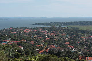
Munyonyo is an area on the northern shores of Lake Victoria and part of the metropolitan area of Kampala, in Makindye Division. Kampala is the capital and largest city of Uganda.

Kajjansi Place in Uganda

Kajjansi is a town in Central Uganda. It is one of the urban centers in Wakiso District.

Busega Place in Uganda

Busega is a neighborhood within Kampala, Uganda's capital and largest city.

Roofings Group, often referred to simply as Roofings, is the largest manufacturer of steel construction materials in Uganda, with installed production capacity of 72,000 metric tonnes annually.

Mutundwe Place in Uganda

Mutundwe is a neighborhood in the town of Ssabagabo in Uganda. The name also refers to Mutundwe Hill, where the neighborhood is located.

The Entebbe–Kampala Expressway, also known as the "Kampala–Entebbe Expressway" or the "Entebbe–Kampala Highway", is a four-lane toll highway in the Central Region of Uganda. The highway links Entebbe International Airport, the country's largest civilian and military airport, to Kampala, the country's capital and largest metropolitan area. Commissioning was originally planned for 2016 but because of the delayed works, commissioning was done on 15 June 2018 by Uganda's sitting President, Yoweri Museveni.

Abayita Ababiri Place in Central Uganda, Uganda

Abayita Ababiri, sometimes spelled Abaita Ababiri, is a neighborhood in Uganda.

Buloba Place in Central Uganda, Uganda

Buloba is an urban area in Wakiso District in the Buganda Region of Uganda. The area is primarily a middle-class residential neighborhood.

Ssabagabo Place in Central Region, Uganda

Ssabagabo, also known as Makindye-Ssabagabo or Ssabagabo-Makindye, is a municipality in Uganda.

The Kampala–Entebbe Road, also known as the Entebbe–Kampala Road or the Entebbe Road, is a road in the Central Region of Uganda, connecting the capital city of Kampala and Entebbe International Airport.

Kisubi Place in Central Region of Uganda

Kisubi is a neighborhood in the Central Region of Uganda.

Kijabijo Place in Buganda, Uganda

Kijabijo is a neighborhood in Kira Town, in Wakiso District in the Buganda Region of Uganda.

Lugonjo Place in Central Uganda, Uganda

Lugonjo is a neighborhood in Entebbe Municipality, Busiro County, Wakiso District, in the Buganda Region of Uganda.

CoRSU Rehabilitation Hospital, is a specialized surgical hospital in the Buganda Region of Uganda. The hospital focuses on the surgical correction and rehabilitation of orthopedic problems which account for over 50 percent of the patients served. About 45 percent of those served, receive plastic surgery, VVF repair and burns treatment.

Zana, Uganda Place in Central Uganda, Uganda

Zana is a neighborhood in Ssabagabo Municipality, Kyaddondo County, Wakiso District, in Central Uganda.

Kigo, Uganda Place in Uganda

Kigo is a neighborhood in the town of Ssabagabo in Uganda. The name also refers to Kigo Hill, that forms part of the neighborhood.

Tondeka Metro Bus Service Ugandan bus company

The Tondeka Metropolitan Kampala Bus Service, is the proposed principal public transport operator in the Kampala metropolitan area. Expected to start in September 2020, the bus system, Tondeka Metro, proposes to serve the city of Kampala, Uganda's capital, the city of Entebbe, including Entebbe International Airport, Buloba, Nsangi, Ssabagabo, Mukono, Kira Town, Matugga, Wakiso, and the areas in Mukono District and Wakiso District that connect with these urban centers.

Nkumba Neighborhood in Uganda

Nkumba is an urban area in Wakiso District in the Buganda Region of Uganda. The area is primarily a university town, on account of Nkumba University, a private university that maintains its main campus in the neighborhood.

References

  1. Mapcarta (7 July 2018). "Map of Lweeza At Mapcarta.com". Mapcarta.com. Retrieved 7 July 2018.
  2. Moses Mulondo, Moses Walubiri, and David Lumu (14 August 2015). "12 new municipalities created". New Vision . Kampala. Retrieved 16 March 2016.
  3. NTV Uganda (9 August 2015). "What is the implication of approving 11 new municipalities?". Kampala: Nation Television Uganda (NTV Uganda). Retrieved 16 March 2016.
  4. Globefeed.com (16 March 2016). "Distance between Entebbe International Airport, Entebbe, Central Region, Uganda and Lweza Conference Center, Kyadondo, Central Region, Uganda". Globefeed.com. Retrieved 16 March 2016.
  5. Globefeed.com (16 March 2016). "Distance between Kampala Road, Kampala, Central Region, Uganda and Lweza Conference Center, Kyadondo, Buganda Region, Uganda". Globefeed.com. Retrieved 16 March 2016.
  6. Google (16 March 2016). "Location of Lweeza, Ssabagabo Municipality, Wakiso District, Buganda Region, Uganda" (Map). Google Maps . Google. Retrieved 16 March 2016.
  7. Wearewater Organization (30 October 2017). "Provision of a water system for the St. Mary Kevin Motherhood Orphanage and School in Lweza, Uganda". Barcelona: Wearewater.org. Retrieved 7 July 2018.
  8. Google (7 July 2018). "Map Showing Kampala–Entebbe Road Passing Through Lweeza" (Map). Google Maps . Google. Retrieved 7 July 2018.
  9. Google (7 July 2018). "Map Showing Relationship Between Leeza And Entebbe–Kampala Expressway" (Map). Google Maps . Google. Retrieved 7 July 2018.
  10. Google (7 July 2018). "Map Showing Kigo Road in Lweeza, Ssabagabo Municipality, Wakiso District" (Map). Google Maps . Google. Retrieved 7 July 2018.
  11. Vision Reporter (29 September 2015). "About Mildmay Uganda". New Vision . Kampala. Retrieved 16 March 2016.
  12. Google (7 July 2018). "Map Showing the Main Office And Factory of Roofings Uganda Limited" (Map). Google Maps . Google. Retrieved 7 July 2018.
  13. Uganda Ministry of Education (19 June 2013). "Government Grades 830 Private Secondary Schools" (PDF). Kampala: Daily Monitor Mobile . Retrieved 7 July 2018.
  14. Misairi Thembo Kahungu (5 January 2019). "Stella Njuba succumbs to cancer". Daily Monitor . Kampala. Retrieved 15 January 2019.

Coordinates: 00°12′36″N32°35′06″E / 0.21000°N 32.58500°E / 0.21000; 32.58500