
Wakiso District is a district in the Central Region of Uganda that partly encircles Kampala, Uganda's capital city. The town of Wakiso is the site of the district headquarters. Kira, the country's second largest city and suburb of Kampala, is in the district.
Kira Town, a municipality in the Wakiso District of the Central Region of Uganda, is the country's second most populous city. It is administered by the Kira Town Council, an urban local government.

Namugongo is a township in the Central Region of Uganda.

Bweyogerere is one of the six townships or wards that constitute Kira Municipality in Wakiso District in southern central Uganda. The other five wards are Kimwaanyi, Kira, Kireka, Kirinnya and Kyaliwajjala.
Kireka is the name of a township in Central Uganda. It is one of the six townships or Wards that constitute Kira Municipality in Wakiso District. The other five Wards in Kira Municipality are Bweyogerere Ward, Kimwaanyi Ward, Kira Ward, Kirinnya Ward and Kyaliwajjala Ward.
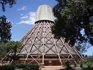
The Basilica of the Uganda Martyrs, Namugongo is a Roman Catholic minor basilica dedicated to the Ugandan Martyrs.
The Kampala Northern Bypass Highway, often referred to as the Northern Bypass, is a road in Uganda. It forms a semicircle across the northern suburbs of Kampala, Uganda's capital and largest city. The road was constructed to relieve traffic congestion within the city center, allowing cross-country traffic to bypass the city's downtown area.
Najjera, sometimes spelled as Najjeera is a neighborhood in Kira Municipality, Wakiso District, in the Buganda Region of Uganda.
Bulindo is a neighborhood in Kira Municipality, Kyaddondo County, Wakiso District, in the Central Region of Uganda.
Nsasa is a neighborhood in Kira Municipality, Kyaddondo County, Wakiso District, in the Central Region of Uganda.

Kajjansi is a town in Central Uganda. It is one of the urban centers in Wakiso District.
Naalya is a township in Kira Municipality, in Kyaddondo County, Wakiso District, in Uganda.
Kigulu is a neighborhood in Kira Municipality, Kyaddondo County, Wakiso District, in Central Uganda.
King Ceasor University is a private university previously known as St. Augustine International University.
Quality Supermarkets is a Ugandan supermarket chain.
Kimwanyi is a neighborhood in Kira Municipality, Wakiso District, in the Buganda Region of Uganda. Kimwanyi also refers to Kimwanyi Parish, in Kira sub-county, Kyaddondo County, Wakiso District. It is one of the six parishes (wards) of Kira Municicipality, namely; Kimwanyi, Kira, Kyaliwajjala, Kireka, Bweyogerere and Kirinnya.
The Kampala Outer Beltway, also known as the Kampala Outer Ring Road, is a planned road in Uganda. It will form a full circle around Kampala, Uganda's capital and largest city.
Mbalwa is a neighborhood in Kyaliwajjala Parish, Kira Municipality, Wakiso District in the Central Region of Uganda.
Mulawa is a neighborhood in Kira Municipality, Kyaddondo County, Wakiso District, in Central Uganda.
The Kyaliwajjala–Kira–Kasangati–Matugga Road, also Kyaliwajjala–Matugga Road or Kira–Matugga Road, is a road in the Central Region of Uganda, connecting the neighborhood of Kyaliwajjala, in Kira Municipality in Wakiso District, to the town of Matugga, also in Wakiso District. This road is part of the 101 kilometres (63 mi) Kampala Outer Beltway Project.

