Maya, Uganda

Last updated
Maya
Uganda location map.svg
Red pog.svg
Maya
Map of Uganda showing the location of Maya
Coordinates: 00°15′59″N32°26′09″E / 0.26639°N 32.43583°E / 0.26639; 32.43583
CountryFlag of Uganda.svg  Uganda
Region Central Uganda
District Wakiso District
County Busiro
Constituency Busiro South
Elevation
1,214 m (3,983 ft)
Population
 (2009 Estimate)
  Total3,100 [1]
Time zone UTC+3 (EAT)

Maya is a town in the Central Region of Uganda. It is one of the urban centers in Wakiso District. [2]

Contents

Location

Maya is located in Maya Parish, Nsangi sub-county, Busiro County, Wakiso District, in Uganda's Central Region. It is located along the Kampala–Masaka Road, approximately 27 kilometres (17 mi), southwest of Kampala, the capital and largest city of Uganda. [3] This is about 15 kilometres (9 mi), by road, north-east of Mpigi Town, the nearest large town. [4] The coordinates of Maya are: 0°15'59.0"N, 32°26'09.0"E (Latitude:0.266389; Longitude:32.435833). [5] Maya, Uganda is situated at an average elevation of 1,214 metres (3,983 ft), above sea level. [6]

Overview

Maya is located in Wakiso District, one of the fastest growing districts in Uganda. [7] This area is attractive to those looking for land to build residential houses, schools and commercial buildings. Maya is an area, in relative proximity to Kampala, situated on a major highway, where land prices are relatively affordable. [8] This has also increased the number of land disputes in the area. [9] [10]

Population

The Uganda Bureau of Statistics estimated the population of Maya at 3,100, in 2009. [1]

Points of interest

The following points of interest are found within the town limits or near the town boundaries: (a) The offices of Maya Town Council (b) Maya Central Market (c) Fiduga Flower Plantation, a horticultural growing and exporting enterprise [11] (d) International Paramedical Institute [2] (e) The Kampala–Masaka Road - The highway passes through town in a northeast to southwest direction (e) London College of St. Lawrence, a private, mixed, residential high school. [12] [13]

See also

Related Research Articles

Wakiso District District in Uganda

Wakiso District is a district in the Central Region of Uganda that partly encircles Kampala, Uganda's capital city. The town of Wakiso is the site of the district headquarters. Kira, the country's second largest city and suburb of Kampala, is in the district.

Mpigi Place in Central Uganda, Uganda

Mpigi is a town in Mawokota County, Mpigi District, in Central Uganda. Mpigi is the municipal, administrative and commercial headquarters of Mpigi District. The district is named after the town.

Uganda Martyrs University Private university in Uganda

Uganda Martyrs University (UMU) is a private university affiliated with the Roman Catholic Church in Uganda. It is licensed by the Uganda National Council for Higher Education. UMU consists of seven faculties, one institute, four centers, five departments, and two schools. As of January 2015, total student enrollment exceeded 5,000. Of these, about 1,500 students were residential, while nearly 3,000 students were enrolled in UMU's distance learning programs. The number of staff members was over 400.

Lukaya, Uganda Place in Central

Lukaya is a town in the Kalungu District of the Central Region of Uganda.

Nsangi Place in Central Uganda, Uganda

Nsangi is a town in the Central Region of Uganda. It is one of the urban centers in Wakiso District.

Busega Place in Uganda

Busega is a neighborhood within Kampala, Uganda's capital and largest city.

Lweeza Place in Central Region, Uganda

Lweeza, also Lweza, is a neighborhood in the Buganda Region of Uganda. The correct phonetic spelling consistent with the local Ganda language is Lweeza.

Mutundwe Place in Uganda

Mutundwe is a neighborhood in the town of Ssabagabo in Uganda. The name also refers to Mutundwe Hill, where the neighborhood is located.

Kyengera Place in Central Region, Uganda

Kyengera is a town in the Central Region of Uganda. It is one of the urban centers in Wakiso District.

Kimwanyi Place in Wakiso District, Uganda

Kimwanyi is a neighborhood in Kira Municipality, Wakiso District, in the Buganda Region of Uganda. Kimwanyi also refers to Kimwanyi Parish, in Kira sub-county, Kyaddondo County, Wakiso District. It is one of the six parishes (wards) of Kira Municicipality, namely; Kimwanyi, Kira, Kyaliwajjala, Kireka, Bweyogerere and Kirinnya.

The Kampala–Mpigi Expressway, also Busega–Mpigi Expressway, is a four-lane, dual carriage highway under construction in the Central Region of Uganda, connecting, Kampala, the capital city, and Mpigi, the headquarters of Mpigi District.

The Kampala Outer Beltway, also known as the Kampala Outer Ring Road, is a planned road in Uganda. It will form a full circle around Kampala, Uganda's capital and largest city.

Entebbe General Hospital Hospital in Entebbe, Uganda

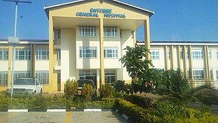
Entebbe General Hospital, commonly known as Entebbe Hospital, is a hospital in the town of Entebbe, in the Central Region of Uganda.

Kitalya Maximum Security Prison is a maximum security prison for both men and women in Uganda.

Kawanda–Birembo High Voltage Power Line is a high voltage electricity power line, under construction, connecting the high voltage substation at Kawanda, in Uganda to another high voltage substation at Birembo, in Rwanda.

Mbalwa Place in Central Region of Uganda, Uganda

Mbalwa is a neighborhood in Kyaliwajjala Parish, Kira Municipality, Wakiso District in the Central Region of Uganda.

Kijabijo Place in Buganda, Uganda

Kijabijo is a neighborhood in Kira Town, in Wakiso District in the Buganda Region of Uganda.

Buwama Place in Central Uganda, Uganda

Buwama is a town in the Buganda Region of Uganda.

Nabbingo Place in Uganda

Nabbingo is a hill in Wakiso District in the Buganda Region of Uganda. The hill rises 1,178 metres (3,865 ft) above sea level. The name "Nabbingo", also applies to the village that occupies the hill and the schools and churches that are located there.

Tondeka Metro Bus Service Ugandan bus company

The Tondeka Metropolitan Kampala Bus Service, is the proposed principal public transport operator in the Kampala metropolitan area. Expected to start in September 2020, the bus system, Tondeka Metro, proposes to serve the city of Kampala, Uganda's capital, the city of Entebbe, including Entebbe International Airport, Buloba, Nsangi, Ssabagabo, Mukono, Kira Town, Matugga, Wakiso, and the areas in Mukono District and Wakiso District that connect with these urban centers.

References

  1. 1 2 Uganda Bureau of Statistics (2009). "Implementation of the Community Information System (CIS): Wakiso District Local Government Report, Based On CIS Summary Results 2009" (PDF). Kampala: Uganda Bureau of Statistics . Retrieved 27 January 2018.
  2. 1 2 Bucouganda.org (27 January 2018). "International Paramedical Institute: Dental School Project". Bucouganda.org. Retrieved 27 January 2018.
  3. Globefeed.com (27 January 2018). "Distance between Post Office Building, Kampala Road, Kampala, Uganda and Maya, Central Region, Uganda". Globefeed.com. Retrieved 27 January 2018.
  4. Globefeed.com (27 January 2018). "Distance between Maya, Central Region, Uganda and Mpigi, Central Region, Uganda". Globefeed.com. Retrieved 27 January 2018.
  5. Google (27 January 2018). "Location of Maya Town, Wakiso District, Central Region, Uganda" (Map). Google Maps . Google. Retrieved 27 January 2018.
  6. Mapcarta.com (27 January 2017). "Average Elevation of Maya, Uganda". Mapcarta.com. Retrieved 27 January 2017.
  7. Moses Nsereko Wakayima (25 April 2011). "Why split Wakiso into three districts now?". New Vision . Kampala. Retrieved 27 January 2018.
  8. Jumia House (28 October 2015). "Affordable Places To Buy Land In Uganda". Kampala: Jumia House Uganda. Retrieved 27 January 2018.
  9. Bagala, Andrew (6 January 2012). "Uganda police boss intervenes in clan land wrangle". The Citizen (Tanzania) . Kampala. Retrieved 27 January 2018.
  10. Wekesa, Anthony (26 January 2018). "Kyeyo man runs to court over land deal gone bad". Daily Monitor . Kampala. Retrieved 27 January 2018.
  11. Levitt, Tom (March 2011). "Uganda's flower dilemma". New Agriculturist. Retrieved 27 January 2018.
  12. Talemwa, Moses (25 October 2009). "Foreign students find home in Uganda". The Observer (Uganda) . Kampala. Retrieved 27 January 2018.
  13. Kafeero, Stephen (4 February 2015). "Wakiso tops as Amudat fails to get first grade". Daily Monitor Monitor . Kampala. Retrieved 27 January 2018.

Coordinates: 00°15′59″N32°26′09″E / 0.26639°N 32.43583°E / 0.26639; 32.43583