Mutundwe

Last updated
Mutundwe
Location map Kampala.png
Red pog.svg
Mutundwe
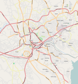
Map of Kampala showing the location of Mutundwe.
Coordinates: 00°16′58″N32°32′03″E / 0.28278°N 32.53417°E / 0.28278; 32.53417
CountryFlag of Uganda.svg  Uganda
Region Central Region
District Wakiso District
Municipality Ssabagabo
Elevation
1,300 m (4,300 ft)
Time zone UTC+3 (EAT)

Mutundwe is a neighborhood in the town of Ssabagabo in Uganda. The name also refers to Mutundwe Hill, where the neighborhood is located.

Contents

Location

Mutundwe is located in the northwestern edge of Ssabagabo municipality in Wakiso District, in Uganda's Central Region. It is bordered by Lungujja to the north, Lubaga to the northeast, Ndeeba and Kabowa to the east, Wankulukuku to the east, Kitebi to the southeast, Kabojja to the west, and Nateete to the northwest. The road distance between Kampala's central business district and Mutundwe is approximately 8 kilometres (5.0 mi). [1] The coordinates of Mutundwe are 0°16'58.0"N, 32°32'03.0"E (Latitude:0.282778; Longitude:32.534167). [2]

Overview

During the first decade of the 21st century, educational institutions such as the Mutundwe Campus of Kampala University have been added to the neighborhood.

The Mutundwe Power Station, a 50 megawatt thermal power plant, was dismantled in 2011, but the Mutundwe electricity sub-station, where the power plant was located, still exists. This sub-station is a major transit point for power evacuated from the hydropower stations along the Nile River before it is transmitted to Entebbe, [3] Masaka, and the Western Region. [4]

Parts of Mutundwe Hill lie in Lubaga Division, within the city of Kampala, Uganda's capital. [5] Other parts lie in the newly created town of Ssabagabo in Wakiso District. Still other parts of the hill lie within unincorporated Wakiso District. [6]

See also

Related Research Articles

Mulago Place in Central Uganda, Uganda

Mulago is a hill in north-central Kampala, the capital city of Uganda. The hill rises 4,134 feet (1,260 m) above sea level. The name also applies to the neighborhoods that sit on this hill.

Lubaga Place in Central Uganda, Uganda

Lubaga is a hill in Kampala, Uganda's capital and largest city. It comes from the Luganda word okubaga, describing a process of "planning" or "strengthening" a structure while constructing it. For example, okubaga ekisenge means to strengthen the internal structure of a wall while building a house. The name also applies to the neighborhood on the hill.

Nateete Place in Central Uganda, Uganda

Nateete is a location in the city of Kampala, Uganda's capital.

Sentema Place in Uganda

Sentema is a town in Wakiso District, central Uganda. The town is a municipality under Wakiso District Administration. The other municipalities in the district include:

Kajjansi Place in Central Uganda, Uganda

Kajjansi is a town in Central Uganda. It is one of the urban centers in Wakiso District.

Busega Place in Central Uganda, Uganda

Busega is a neighborhood within Kampala, Uganda's capital and largest city.

Lweeza Place in Central Region, Uganda

Lweeza, also Lweza, is a neighborhood in the Buganda Region of Uganda. The correct phonetic spelling consistent with the local Ganda language is Lweeza.

The Entebbe–Kampala Expressway, also known as the "Kampala–Entebbe Expressway" or the "Entebbe–Kampala Highway", is a four-lane toll highway in the Central Region of Uganda. The highway links Entebbe International Airport, the country's largest civilian and military airport, to Kampala, the country's capital and largest metropolitan area. Originally, the highway was planned for commissioning in 2016, but because of the delayed works, commissioning was done on 15 June 2018 by Uganda's sitting president, Yoweri Museveni. Recently, the Uganda Minister for Works and Transport, Gen. Katumba Wamala launched the toll point at Kajjansi along Kampala–Entebbe Road.

Kyengera Place in Central Region, Uganda

Kyengera is a town in the Central Region of Uganda. It is one of the urban centers in Wakiso District.

Kanyanya Place in Central Uganda, Uganda

Kanyanya is a neighborhood within the city of Kampala, Uganda's capital.

Abayita Ababiri Place in Central Uganda, Uganda

Abayita Ababiri, sometimes spelled Abaita Ababiri, is a neighborhood in Uganda.

Buloba Place in Central Uganda, Uganda

Buloba is an urban area in Wakiso District in the Buganda Region of Uganda. The area is primarily a middle-class residential neighborhood.

Ssabagabo Place in Central Region, Uganda

Ssabagabo, also known as Makindye-Ssabagabo or Ssabagabo-Makindye, is a municipality in Uganda.

The Kampala–Gayaza Road is a road in the Central Region of Uganda, connecting the capital city of Kampala to the town of Gayaza in the Wakiso District. The road is part of the 44 kilometres (27 mi) Kampala–Gayaza–Ziroobwe Road Project.

Akright City Community in Wakiso District of the Central Region of Uganda

Akright City is a residential community in Wakiso District of the Central Region of Uganda.

Kabojja Place in Central Region of Uganda, Uganda

Kabojja is a neighborhood in Wakiso District, in the Central Region of Uganda.

Kisubi Place in Central Region of Uganda, Uganda

Kisubi is a neighborhood in the Central Region of Uganda.

Kadic Hospital, also known as Kadic Medical Centre, is an urban, private, hospital in Kampala, the capital of Uganda and the largest city in that country. The hospital was taken over the Victoria Hospitals Limited and renamed UMC Victoria Hospital in January 2017. Following the commissioning of the newly constructed state-of-art UMC Victoria Hospital across the road, the facility was decommissioned in January 2018 and is expected to be re-opened following renovation in 2019.

Lugonjo Place in Central Uganda, Uganda

Lugonjo is a neighborhood in Entebbe Municipality, Busiro County, Wakiso District, in the Buganda Region of Uganda.

Zana, Uganda Place in Central Uganda, Uganda

Zana is a neighborhood in Ssabagabo Municipality, Kyaddondo County, Wakiso District, in Central Uganda. The place was named after a powerful business woman in 80s called Zana.

References

  1. GFC (15 March 2016). "Distance between Kampala Road, Kampala, Central Region, Uganda and Mutundwe, Ssabagabo, Central Region, Uganda". Globefeed.com (GFC). Retrieved 15 March 2016.
  2. Google (15 March 2016). "Location of Mutundwe, Ssabagabo, Wakiso District, Uganda" (Map). Google Maps . Google. Retrieved 15 March 2016.
  3. Musisi, Frederic (31 March 2014). "Germany Approves Shs73 Billion for New Entebbe Power Line". Daily Monitor . Retrieved 20 June 2014.
  4. Nabwiiso, Samuel (31 July 2012). "UETCL To Expand Power Grid". The Observer (Uganda) . Retrieved 20 June 2014.
  5. UTG (15 March 2016). "Profile of Mutundwe Hill". Uganda Travel Guide (UTG). Retrieved 15 March 2016.
  6. LCMTO (15 March 2016). "Map of Ssabagabo Municipality". Lcmt.org (LCMTO). Retrieved 15 March 2016.

Coordinates: 00°16′58″N32°32′03″E / 0.28278°N 32.53417°E / 0.28278; 32.53417