Ssabagabo

Last updated
Ssabagabo
Ssabagabo-Makindye
Uganda location map.svg
Red pog.svg
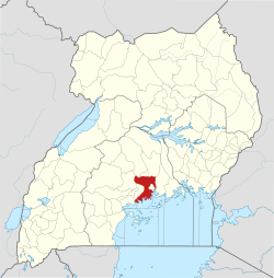
Ssabagabo
Location in Uganda
Placement on map is approximate
Coordinates: 00°14′34″N32°33′36″E / 0.24278°N 32.56000°E / 0.24278; 32.56000 Coordinates: 00°14′34″N32°33′36″E / 0.24278°N 32.56000°E / 0.24278; 32.56000
Country Flag of Uganda.svg Uganda
Region Central Region
District Wakiso District
Municipality Ssabagabo
County Kyaddondo
Constituency Ssabagabo Municipality
Government
   Mayor Kawuma Cedric
Elevation
3,870 ft (1,180 m)
Population
 (2014 Census)
  Total284,067 [1]

Ssabagabo, also known as Makindye-Ssabagabo or Ssabagabo-Makindye, is a municipality in Uganda. [2] [3]

Contents

Location

The town is located in the hitherto unincorporated Wakiso District, immediately south of Kampala's Makindye Division. It includes the following neighborhoods, among others: Mutundwe, Najjanankumbi, Zana, Bunnamwaya, Seguku, Lubowa, Ndejje-Lubugumu, Busaabala, Masajja, Kaazi, Lweeza, Kigo, and Kubbiri. [4] The coordinates of the new town are 0°14'34.0"N, 32°33'36.0"E (Latitude:0.242789; Longitude:32.559987). [5]

Overview

Before its current status, the town was a sub-county in Wakiso District. [6] Generally, the town is already built-up and consists of mainly middle and upper-class neighborhoods. [7] In the Lubowa neighborhood, Roofings Limited maintains two of its three component companies and factories. The old Kampala–Entebbe Road passes through the eastern portion of the town in a general north-to-south direction. The Munyonyo spur of the new Entebbe–Kampala Expressway passes through the southern portion of the new town in a general west-to-east direction. [4]

Administration

During the 2016/2017 financial year, which began on 1 July 2016 and ended on 30 June 2017, the municipality budgeted to spend more than USh10 billion. Of that, UShs4.8 billion was expected to come from local taxes while the government of Uganda was expected to contribute USh5.9 billion. [8] However the work in the district was hampered by a slow recruitment process, with only 15 out of the required 90 positions filled as of October 2016. [8]

Population

During the national census and household survey of 27 and 28 August 2014, the Uganda Bureau of Statistics (UBOS), enumerated the population of Ssabagabo Municipality at 410,044 people. [1]

See also

Related Research Articles

<span class="mw-page-title-main">Entebbe</span> Place in Central Uganda, Uganda

Entebbe is a city in Central Uganda. Located on a Lake Victoria peninsula, approximately 36 kilometres (22 mi) southwest of the Ugandan capital city, Kampala. Entebbe was once the seat of government for the Protectorate of Uganda prior to independence, in 1962. The city is the location of Entebbe International Airport, Uganda's largest commercial and military airport, best known for the Israeli rescue of 100 hostages kidnapped by the militant group of the PFLP-EO and Revolutionary Cells (RZ) organizations. Entebbe is also the location of State House, the official office and residence of the President of Uganda.

<span class="mw-page-title-main">Wakiso District</span> District in Central Uganda, Uganda

Wakiso District is a district in the Central Region of Uganda that partly encircles Kampala, Uganda's capital city. The town of Wakiso is the site of the district headquarters. Kira, the country's second largest city and suburb of Kampala, is in the district.

<span class="mw-page-title-main">Makindye</span> Place in Central Uganda, Uganda

Makindye is a hill in Kampala, Uganda's largest city and capital. The name also refers to the neighborhood that sits on that hill. Makindye is also the seat of Makindye Division, one of the five administrative zones of the city of Kampala.

Kira Town, a municipality in the Wakiso District of the Central Region of Uganda, is the country's second-largest city by population. It is administered by the Kira Town Council, an urban local government.

<span class="mw-page-title-main">Munyonyo</span> Place in Central Region of Uganda, Uganda

Munyonyo is an area on the northern shores of Lake Victoria and part of the metropolitan area of Kampala, in Makindye Division.

Nansana is a town in the Central Region of Uganda. It is located in the Wakiso District and is one of the five municipalities in the district. Nansana is a municipal council comprising four Divisions; Nansana Division, Nabweru Division, Gombe Division, and Busukuma Divisions. The four Divisions are considered as lower local government independent units.

<span class="mw-page-title-main">Bweyogerere</span> Place in Wakiso District, Uganda

Bweyogerere is one of the six townships or wards that constitute Kira Municipality in Wakiso District in southern central Uganda. The other five wards are Kimwaanyi, Kira, Kireka, Kirinnya and Kyaliwajjala.

Sentema is a town in Wakiso District, central Uganda. The town is a municipality under Wakiso District Administration. The other municipalities in the district include:

The Kampala Northern Bypass Highway, often referred to as the Northern Bypass, is a road in Uganda. It forms a semicircle across the northern suburbs of Kampala, Uganda's capital and largest city. The road was constructed to relieve traffic congestion within the city center, allowing cross-country traffic to bypass the city's downtown area.

Nsasa is a neighborhood in Kira Municipality, Kyaddondo County, Wakiso District, in the Central Region of Uganda.

Lweeza, also Lweza, is a neighborhood in the Buganda Region of Uganda. The correct phonetic spelling consistent with the local Ganda language is Lweeza.

Mutundwe is a neighborhood in the town of Ssabagabo in Uganda. The name also refers to Mutundwe Hill, where the neighborhood is located.

The Entebbe–Kampala Expressway, also known as the "Kampala–Entebbe Expressway" or the "Entebbe–Kampala Highway", is a four-lane toll highway in the Central Region of Uganda. The highway links Entebbe International Airport, the country's largest civilian and military airport, to Kampala, the country's capital and largest metropolitan area. Originally, the highway was planned for commissioning in 2016, but because of the delayed works, commissioning was done on 15 June 2018 by Uganda's sitting president, Yoweri Museveni. Recently, the Uganda Minister for Works and Transport, Gen. Katumba Wamala launched the toll point at Kajjansi along Kampala–Entebbe Road.

Kitikifumba is a neighborhood in Kira Municipality, Kyaddondo County, Wakiso District, in the Central Region of Uganda.

Kimwanyi is a neighborhood in Kira Municipality, Wakiso District, in the Buganda Region of Uganda. Kimwanyi also refers to Kimwanyi Parish, in Kira sub-county, Kyaddondo County, Wakiso District. It is one of the six parishes (wards) of Kira Municicipality, namely; Kimwanyi, Kira, Kyaliwajjala, Kireka, Bweyogerere and Kirinnya.

<span class="mw-page-title-main">Entebbe General Hospital</span> Hospital in Central Region, Uganda

Entebbe General Hospital, commonly known as Entebbe Hospital, is a hospital in the town of Entebbe, in the Central Region of Uganda.

The International Specialized Hospital of Uganda (ISHU) is a public, specialized, referral tertiary care medical facility under construction in Uganda. The hospital is expected to take two years to construct. The private developers who are constructing the hospital will operate it for ten years, then turn it over to the government of Uganda, in a public-private partnership arrangement.

Zana is a neighborhood in Ssabagabo Municipality, Kyaddondo County, Wakiso District, in Central Uganda. The place was named after a powerful business woman in 80s called Zana.

Kigo is a neighborhood in the town of Ssabagabo in Uganda. The name also refers to Kigo Hill, that forms part of the neighborhood.

The Tondeka Metropolitan Kampala Bus Service (TMBS), is the proposed principal public transport operator in the Kampala metropolitan area. Expected to start in September 2020, the bus system, Tondeka Metro, proposes to serve the city of Kampala, Uganda's capital, the city of Entebbe, including Entebbe International Airport, Buloba, Nsangi, Ssabagabo, Mukono, Kira Town, Matugga, Wakiso, and the areas in Mukono District and Wakiso District that connect with these urban centers.

References

  1. 1 2 UBOS (November 2014). "National Population and Housing Census 2014: Provisional Results: Appendix 3 - Households and Population by Subcounty/ Town Council/Urban Division and Sex, 2014" (PDF). Kampala: Uganda Bureau of Statistics (UBOS). Retrieved 31 July 2017.
  2. Moses Mulondo, Moses Walubiri, and David Lumu (14 August 2015). "12 new municipalities created". New Vision . Kampala. Retrieved 15 March 2016.
  3. NTVU (9 August 2015). "What is the implication of approving 11 new municipalities?". Kampala: Nation Television Uganda (NTVU). Retrieved 15 March 2016.
  4. 1 2 LCMTO (15 March 2016). "Map of Ssabagbo Municipality". Lcmt.org (LCMTO). Retrieved 15 March 2016.
  5. Google (15 March 2016). "Location of Ssabagabo Municipality, Wakiso District, Uganda" (Map). Google Maps . Google. Retrieved 15 March 2016.
  6. Balagadde, Samuel (24 September 2008). "Uganda: Ssabagabo Gets Sub-County Status". New Vision . Kampala. Retrieved 15 March 2016.
  7. Kampala City Tours (15 June 2016). "Kampala City Tours: The Rich Verses The Poor In Kampala - Where the Rich and the Poor Live in Kampala". Kampala: Kampala City Tours. Retrieved 15 June 2016.
  8. 1 2 Joseph Kiggundu, and James Kabengwa (27 October 2016). "Uganda: Staff Shortage Cripples Work in Wakiso Divisions". Daily Monitor via AllAfrica.com . Kampala. Retrieved 31 July 2017.