
The Big Dig was a megaproject in Boston that rerouted the then elevated Central Artery of Interstate 93 that cut across Boston into the O'Neill Tunnel and built the Ted Williams Tunnel to extend Interstate 90 to Logan International Airport. Those two projects were the origin of the official name, the Central Artery/Tunnel Project. Additionally, the project constructed the Zakim Bunker Hill Bridge over the Charles River, created the Rose Kennedy Greenway in the space vacated by the previous I-93 elevated roadway, and funded more than a dozen projects to improve the region's public transportation system. Planning for the project began in 1982; the construction work was carried out between 1991 and 2006; and the project concluded on December 31, 2007. The project's general contractor was Bechtel and Parsons Brinckerhoff was the engineer, who worked as a consortium, both overseen by the Massachusetts Highway Department.

Transportation in Boston includes roadway, subway, regional rail, air, and sea options for passenger and freight transit in Boston, Massachusetts. The Massachusetts Port Authority (Massport) operates the Port of Boston, which includes a container shipping facility in South Boston, and Logan International Airport, in East Boston. The Massachusetts Bay Transportation Authority (MBTA) operates bus, subway, short-distance rail, and water ferry passenger services throughout the city and region. Amtrak operates passenger rail service to and from major Northeastern cities, and a major bus terminal at South Station is served by varied intercity bus companies. The city is bisected by major highways I-90 and I-93, the intersection of which has undergone a major renovation, nicknamed the Big Dig.

Interstate 93 (I-93) is an Interstate Highway in the New England states of Massachusetts, New Hampshire, and Vermont in the United States. Spanning approximately 190 miles (310 km) along a north–south axis, it is one of three primary Interstate Highways located entirely within New England; the other two are I-89 and I-91. The largest cities along the route are Boston, and Manchester, New Hampshire; it also travels through the New Hampshire state capital of Concord.

The Massachusetts Turnpike is a controlled-access toll highway in the US state of Massachusetts that is maintained by the Massachusetts Department of Transportation (MassDOT). It is concurrent with the entirety of Interstate 90 (I-90) within the state, and is the longest Interstate Highway in Massachusetts, spanning 138 miles (222 km) along an east–west axis.

The Dewey Square Tunnel in Boston, Massachusetts, is part of Interstate 93, running under the heart of the city's financial district, including Dewey Square. Built in 1959, it was part of Boston's Central Artery freeway construction project of the 1950s. Known to locals as the South Station Tunnel, the Dewey Square Tunnel is of cut-and-cover design, and originally was six lanes wide, with no breakdown lanes.

South Station, officially The Governor Michael S. Dukakis Transportation Center at South Station, is the largest railroad station and intercity bus terminal in Greater Boston and New England's second-largest transportation center after Logan International Airport. Located at the intersection of Atlantic Avenue and Summer Street in Dewey Square, Boston, Massachusetts, the historic station building was constructed in 1899 to replace the downtown terminals of several railroads. Today, it serves as a major intermodal domestic transportation hub, with service to the Greater Boston region and the Northeastern and Midwestern United States. It is used by thousands of commuter rail and intercity rail passengers daily. Connections to the rapid transit Red Line and bus rapid transit Silver Line are made through the adjacent subway station.
The Southwest Corridor or Southwest Expressway was a project designed to bring an eight-lane highway into the City of Boston from a direction southwesterly of downtown. It was supposed to connect with Interstate 95 (I-95) at Route 128. As originally designed, it would have followed the right of way of the former Penn Central/New Haven Railroad mainline running from Readville, north through Roslindale, Forest Hills and Jamaica Plain, where it would have met the also-cancelled I-695. The 50-foot-wide median for the uncompleted "Southwest Expressway" would have carried the southwest stretch of the MBTA Orange Line within it, replacing the Washington Street Elevated railway's 1901/1909-built elevated railbed. Another highway, the four-lane South End Bypass, was proposed to run along the railroad corridor between I-695 in Roxbury and I-90 near Back Bay.

The North–South Rail Link (NSRL) is a proposed rail tunnel, or pair of tunnels, that would connect North Station and South Station in downtown Boston, Massachusetts, linking rail networks that serve the city's northern suburbs, New Hampshire, and Maine with the rest of the country. The project would build new underground stations near the existing stations, connect them with about 1.5 miles (2.4 km) of tunnels, and add other tunnels to link up with existing surface tracks.
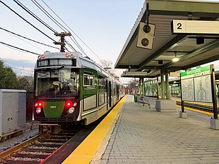
Riverside station is a Massachusetts Bay Transportation Authority (MBTA) Green Line light rail station located in the Auburndale village of Newton, Massachusetts. It is the western terminal of the Green Line D branch service. The station is located near the interchange of Interstate 95 and the Massachusetts Turnpike (I-90) and serves as a regional park and ride station. West of the station is Riverside Yard, the main maintenance facility and largest storage yard for the Green Line. The station is fully accessible.

The Rose Fitzgerald Kennedy Greenway is a linear park located in several Downtown Boston neighborhoods. It consists of landscaped gardens, promenades, plazas, fountains, art, and specialty lighting systems that stretch over one mile through Chinatown, the Financial District, the Waterfront, and North End neighborhoods. Officially opened in October 2008, the 17-acre Greenway sits on land created from demolition of the John F. Fitzgerald Expressway as part of the Big Dig project.

Interstate 695 was a planned six-lane auxiliary Interstate Highway in Boston, Massachusetts, that would have run through parts of Boston, Brookline, Cambridge, and Somerville.
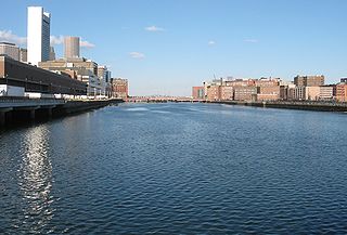
Fort Point Channel is a maritime channel separating South Boston from Downtown Boston, feeding into Boston Harbor. The south part of it has been gradually filled in for use by the South Bay rail yard and several highways. At its south end, the channel once widened into South Bay, from which the Roxbury Canal continued southwest where the Massachusetts Avenue Connector is now. The Boston Tea Party occurred at its northern end. The channel is surrounded by the Fort Point neighborhood, which is also named after the same colonial-era fort.
The Central Artery is a section of freeway in downtown Boston, Massachusetts; it is designated as Interstate 93, US 1 and Route 3.

Community College station is a rapid transit station on the MBTA Orange Line in Boston, Massachusetts. It is located in the Charlestown neighborhood off Austin Street near New Rutherford Avenue (MA-99), under the double-decked elevated structure carrying Interstate 93 to the Zakim Bunker Hill Bridge. The station is named for the adjacent Bunker Hill Community College. The station opened in April 1975, replacing the City Square and Thompson Square stations of the Charlestown Elevated. It was made accessible around 2005.

Tufts Medical Center station is an underground Massachusetts Bay Transportation Authority (MBTA) rapid transit station in Boston, Massachusetts. It serves the MBTA subway Orange Line, as well as two Silver Line bus rapid transit routes on the surface. It is named for the Tufts Medical Center and is built under a wing of the facility that crosses over Washington Street in downtown Boston between Kneeland Street in Chinatown and the Massachusetts Turnpike. The accessible station has two side platforms for the Orange Line.

Route 3 is a state-numbered route in the U.S. state of Massachusetts, maintained by the Massachusetts Department of Transportation (MassDOT). Spanning approximately 56 miles (90 km) along a north–south axis, it is inventoried with U.S. Route 3 as a single route by the state. The state-numbered Route 3 travels from Bourne in the south to Cambridge in the north, while US 3 continues from Cambridge and crosses the New Hampshire state line in Tyngsborough. Mileposts on US 3 continue from those on the state-numbered Route 3.

Route 28 is a 151.93-mile-long (244.51 km) nominally south–north state highway in the U.S. state of Massachusetts, running from the town of Eastham via Boston to the New Hampshire state line in Methuen. Following the route from its nominally southern end, Route 28 initially heads south to the town of Chatham then turns west to follow along the south shore of Cape Cod. In Falmouth, Route 28 turns north and continues through the western part of Plymouth County and the eastern part of Norfolk County; it then passes through downtown Boston before heading north via Lawrence to the New Hampshire state line, where it continues as New Hampshire Route 28.

The Thomas P. "Tip" O'Neill Jr. Tunnel is a highway tunnel built as part of the Big Dig in Boston, Massachusetts. It carries the Central Artery underneath downtown Boston, and is numbered as Interstate 93 (I-93), U.S. Route 1 (US 1), and Route 3. It roughly follows the route of the old elevated Central Artery, though the northbound entrance, at the corner of Kneeland Street and Atlantic Avenue, is somewhat east of the southbound exit to allow for a reconfigured interchange with the Massachusetts Turnpike. It runs from the Zakim Bunker Hill Bridge at its north portal—barely 165 feet (50 m) east of the TD Garden sports facility's eastern corner—to Boston's Chinatown at its south portal. The tunnel is named for Tip O'Neill, former Speaker of the United States House of Representatives, whose constituency included several of the surrounding communities in Metro Boston.
The Inner Belt District is a 126-acre (0.51 km2) industrial district located in the southeastern portion of Somerville, Massachusetts, United States. Along with nearby Brickbottom, the Inner Belt is a historically industrial zone of Somerville, with factories, warehouses, distribution centers, railroad connections, regional maintenance facilities, MBTA and Amtrak offices, retail stores and a hotel.

Beacon Park Yard was a CSX Transportation rail yard in Allston, Boston, now owned by Harvard University. The yard opened in 1890 on the site of a former trotting park, from which it took its name. It was closed in 2013 following the relocation of the yard's container operations to Worcester, Massachusetts, and opening of a transload facility in Westborough, Massachusetts. Plans for the yard include relocation of the Massachusetts Turnpike Allston exit, construction of a new MBTA commuter rail station, a major real estate development, and possibly a rail layover yard.
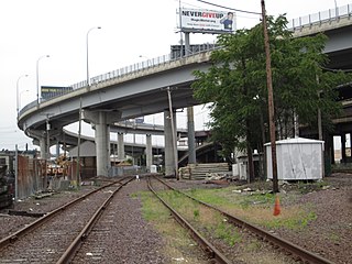
 Overlooking South Bay Interchange toward the south-southwest from One Financial Center in Boston, with the Great Blue Hill visible in the background
 Traffic detoured onto I-93 at the South Bay Interchange after the Big Dig ceiling collapse.

