Southern Wisconsin Regional Airport

Last updated
Southern Wisconsin Regional Airport
Southern Wisconsin Regional Airport - Wisconsin.jpg
2006 USGS airphoto
Summary
Airport typePublic
Owner Rock County
Serves Janesville, Wisconsin
LocationTown of Rock, Rock County
Time zone CST (UTC−06:00)
  Summer (DST)CDT (UTC−05:00)
Elevation  AMSL 808 ft / 246 m
Coordinates 42°37′13″N89°02′30″W / 42.62028°N 89.04167°W / 42.62028; -89.04167
Website jvlairport.com
Map
USA Wisconsin relief location map.svg
Airplane silhouette.svg
JVL
Location of airport in Wisconsin
Usa edcp relief location map.png
Airplane silhouette.svg
JVL
JVL (the United States)
Runways
Direction LengthSurface
ftm
14/327,3022,226Concrete
4/226,7012,042Asphalt
18/365,0041,525Asphalt
Statistics
Aircraft operations (2021)54,744
Based aircraft (2024)87

Southern Wisconsin Regional Airport( IATA : JVL, ICAO : KJVL, FAA LID : JVL) is a public airport located southwest of Janesville and north of Beloit in Rock County, Wisconsin, United States. [1] Formerly known as Rock County Airport, it is owned and operated by the Rock County government. The airport has no scheduled commercial passenger service.

Contents

It is included in the Federal Aviation Administration (FAA) National Plan of Integrated Airport Systems for 2021–2025, in which it is categorized as a national general aviation facility. [2]

Southern Wisconsin Regional Airport was once home to the annual Southern Wisconsin AirFEST.

History

Several Rock County farms provided land for contract glider pilot training to the United States Army Air Forces in 1942. Training was provided by Morey Airplane Company using three turf runway locations in three township sections. C-47 Skytrains and Waco CG-4 unpowered Gliders were not used. The production CG-4A gliders were not delivered until after these northern civilian schools were closed. Aircraft furnished by the Army were single engine L type Cessna, Aeronca and Piper. There were no gliders and there was no glider towing. These schools became known as dead stick training.

The mission of the school was to train glider pilot students in approaches with the engine off, landing at a mark, night landing and strange field landing. Ground school instruction was in navigation, maintenance, meteorology, instruments, aircraft identification, chemical warfare defense, customs of service and physical training and drill.

These schools were inactivated at the end of 1942 or sooner. The farm fields used in Rock County were turned back to the farmers when the schools were closed. None of this glider pilot training in Rock County occurred at or on the current Southern Wisconsin Regional Airport space.

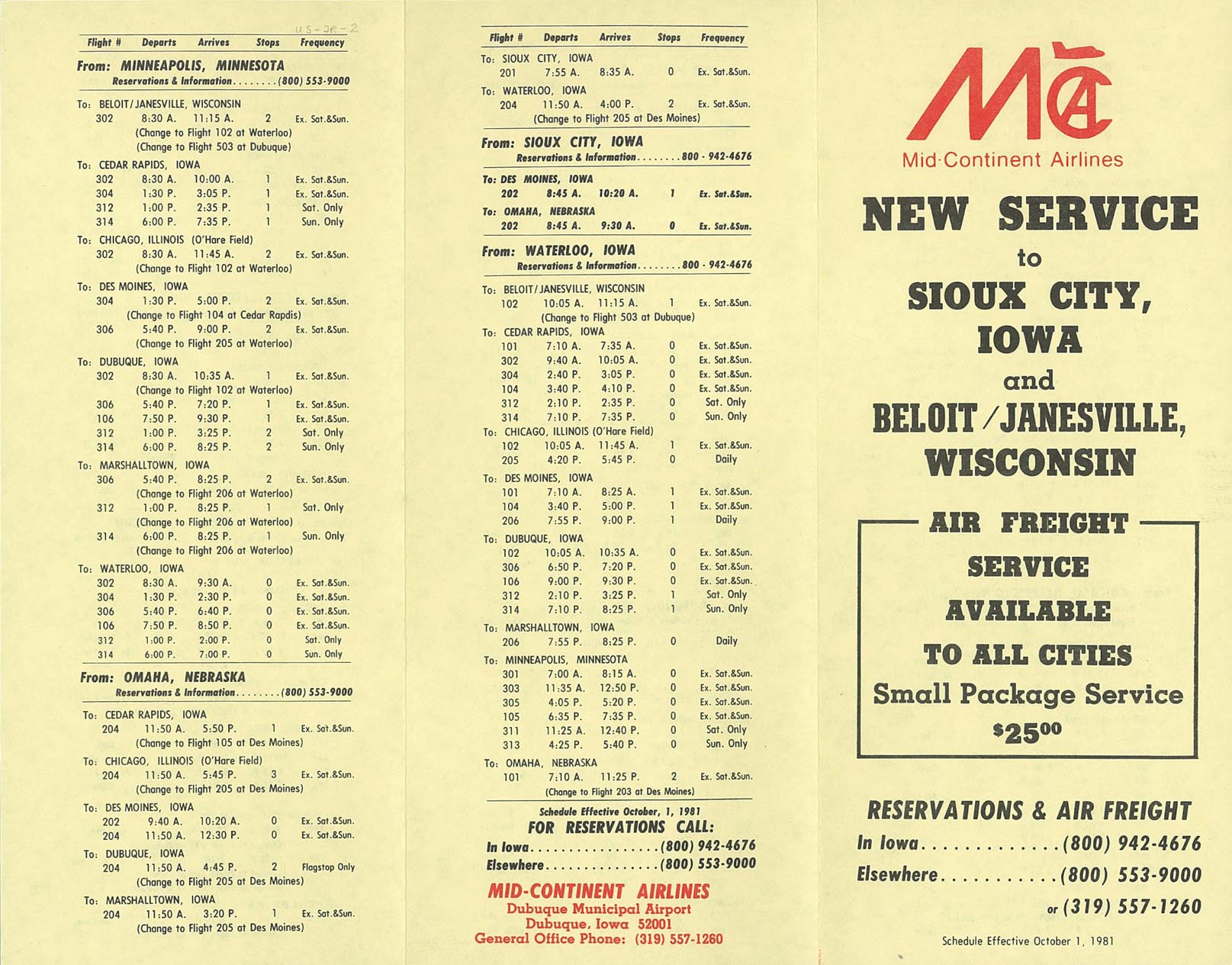
SWRA has, in the past, had scheduled airline passenger service. Wisconsin Central Airlines (later North Central and Republic) began service May 14, 1950. [3] In 1979, it had service to Chicago-O'Hare on Republic Airlines and Midstate Airlines. [4] Republic's service ended October, 1981; Midstate's service began April 15, 1979 and ended December 31, 1979. Mid-Continent Airlines (later American Central Airlines) began service October 1, 1981, [5] which ended July 25, 1985.

Facilities and aircraft

Southern Wisconsin Regional Airport covers an area of 1,343 acres (543  ha ) at an elevation of 808 feet (246 m) above mean sea level. It contains three runways: [1]

For the 12-month period ending December 31, 2021, the airport had 54,744 aircraft operations, an average of 150 per day: 90% general aviation, 10% air taxi and less than 1% military. In April 2024, there were 87 aircraft based at this airport: 45 single-engine, 5 multi-engine, 33 jet and 4 helicopters. [1]

The airport has an FBO that offers fuel as well as hangar parking, catering, courtesy cars, a conference room, a crew lounge, snooze rooms, and more. [6]

Southern Wisconsin AirFest

The Southern Wisconsin AirFest was an annual air show that hosted North American jet teams, such as the Blue Angels, the Thunderbirds and the Masters of Disaster. The event was discontinued following the 2012 season. [7]

Headliners

Accidents & Incidents


See also

Related Research Articles

<span class="mw-page-title-main">Mobile Regional Airport</span> Airport in Mobile County, Alabama, US

Mobile Regional Airport is a public/military airport 13 miles (21 km) west of Mobile, in Mobile County, Alabama, United States. The airport is owned and operated by the Mobile Airport Authority, a self-funded entity that receives no local tax dollars.

<span class="mw-page-title-main">Lubbock Preston Smith International Airport</span> Airport in Lubbock County, Texas

Lubbock Preston Smith International Airport is five miles north of Lubbock, in Lubbock County, Texas, United States. Originally Lubbock International Airport, it was renamed in 2004 for former Texas governor Preston E. Smith, an alumnus of Texas Tech University.

<span class="mw-page-title-main">Rickenbacker International Airport</span> Airport in near Columbus, Ohio

Rickenbacker International Airport is a civil-military public airport 10 miles (16 km) south of downtown Columbus, near Lockbourne in southern Franklin County, Ohio, United States. The south end of the airport extends into Pickaway County. The base was named for flying ace and Columbus native Eddie Rickenbacker. It is managed by the Columbus Regional Airport Authority, which also operates John Glenn Columbus International Airport and Bolton Field. Rickenbacker International is primarily a cargo airport for the city of Columbus, although since 2012 it has served an increasing number of passenger flights as well as charter carriers.

<span class="mw-page-title-main">Greater Binghamton Airport</span> Airport in New York, United States

Greater Binghamton Airport is a county-owned American airport eight miles north of Binghamton, in Broome County, New York. It is in East Maine, New York and serves the Southern Tier of New York.

<span class="mw-page-title-main">University of Illinois Willard Airport</span> Airport in Champaign County, Illinois, U.S.

University of Illinois Willard Airport is south of Savoy in Tolono Township, Champaign County, Illinois, United States. It is owned and operated by the University of Illinois Urbana–Champaign and is named for former University of Illinois president Arthur Cutts Willard.

<span class="mw-page-title-main">Presque Isle International Airport</span> Airport

Presque Isle International Airport, formally Northern Maine Regional Airport at Presque Isle, is a mile northwest of Presque Isle, in Aroostook County, Maine, United States. It serves the residents of Presque Isle and a vast area of northern Maine and northwestern New Brunswick. Airline flights to Newark Liberty International Airport are subsidized by the federal government's Essential Air Service program at a cost of $3,892,174.

<span class="mw-page-title-main">Rocky Mountain Metropolitan Airport</span> Airport in Broomfield, Colorado

Rocky Mountain Metropolitan Airport is a public-use airport located in Broomfield, Colorado, United States. The airport is owned and operated by Jefferson County and is situated midway between Denver and Boulder on U.S. Highway 36. It is located 16 miles (26 km) northwest of the central business district of Denver, and is the closest airport to downtown Denver. The airport covers 1,700 acres (688 ha) and has three runways. Formerly known as Jefferson County Airport or Jeffco Airport, the airport was renamed Rocky Mountain Metropolitan Airport on October 10, 2006, although it is sometimes referred to as Rocky Mountain Regional Airport, e.g., on 2007–2012 county planning documents.

<span class="mw-page-title-main">Kirksville Regional Airport</span> Domestic airport serving Kirksville, Missouri, United States

Kirksville Regional Airport is four miles south of Kirksville, Missouri, on the west side of US highway 63. One airline schedules passenger flights, subsidized by the Essential Air Service program.

<span class="mw-page-title-main">Dothan Regional Airport</span> Airport in Dale County, Alabama

Dothan Regional Airport is a public airport in Dale County, Alabama, United States, seven miles northwest of Dothan, a city mostly in Houston County.

<span class="mw-page-title-main">Montgomery Regional Airport</span> Airport

Montgomery Regional Airport is a civil-military airport seven miles southwest of Montgomery, the capital of Alabama. Owned by the Montgomery Airport Authority, it is used for general aviation and military aviation, and sees two airlines.

<span class="mw-page-title-main">Williamsport Regional Airport</span> Commercial airport in Williamsport, Pennsylvania

Williamsport Regional Airport serves Williamsport, Pennsylvania, and the surrounding area with a population of roughly 200,000. The airport processes approximately 40,000 passengers annually and has served north central Pennsylvania since 1929.

<span class="mw-page-title-main">Chicago Rockford International Airport</span> Airport in Winnebago County, IL, USA

Chicago Rockford International Airport, typically referred to as Rockford International Airport, Chicago Rockford, or by its IATA call letters, RFD, is a commercial airport in Rockford, Illinois, located 68 miles northwest of Chicago. Established in 1946, the airport was built on the grounds of the former Camp Grant facility, which served as one of the largest training facilities for the U.S. Army during both World Wars. The Federal Aviation Administration (FAA) National Plan of Integrated Airport Systems for 2023–2027 categorized it as a non-hub primary commercial service facility.

<span class="mw-page-title-main">La Crosse Regional Airport</span> Airport located in La Crosse, Wisconsin

La Crosse Regional Airport is a public airport located 5 nautical miles northwest of La Crosse, a city in La Crosse County, Wisconsin, United States. Until August 2013 the airport was called La Crosse Municipal Airport.

<span class="mw-page-title-main">Greenville Downtown Airport</span> Airport in Greenville County, South Carolina

Greenville Downtown Airport is an airport three miles east of Greenville, South Carolina, United States. It is owned by the Greenville Airport Commission and is the busiest general aviation airport in South Carolina.

<span class="mw-page-title-main">Spencer Municipal Airport</span> Airport in Clay County, Iowa

Spencer Municipal Airport, also known as Northwest Iowa Regional Airport, is a public airport located three miles (5 km) northwest of the central business district of Spencer, a city in Clay County, Iowa, United States. It is owned by the City of Spencer.

<span class="mw-page-title-main">Langlade County Airport</span> Airport in Antigo, Wisconsin

Langlade County Airport is a county-owned public-use airport located two nautical miles (4 km) northeast of the central business district of Antigo, a city in Langlade County, Wisconsin, United States. It is included in the Federal Aviation Administration (FAA) National Plan of Integrated Airport Systems for 2021–2025, in which it is categorized as a basic general aviation facility.

<span class="mw-page-title-main">Lawrenceville–Vincennes International Airport</span> Airport in Lawrence County, Illinois

Lawrenceville–Vincennes International Airport is a public use airport in Lawrence County, Illinois, United States. Owned by the Bi-State Authority, it is located three nautical miles (6 km) northeast of the city of Lawrenceville, Illinois and also serves the city of Vincennes in Knox County, Indiana. This airport is included in the National Plan of Integrated Airport Systems for 2011–2015, which categorized it as a general aviation facility.

<span class="mw-page-title-main">Northwest Florida Beaches International Airport</span> Airport serving Panama City, Florida, United States

Northwest Florida Beaches International Airport is a public airport 18 miles (29 km) northwest of Panama City, Florida, United States, in Bay County. The airport is owned by the Panama City-Bay County Airport & Industrial District, and is north of Panama City Beach, near West Bay. It replaced Panama City–Bay County International Airport, which was located in Panama City.

<span class="mw-page-title-main">Marion Municipal Airport (Ohio)</span> Public use airport in Marion, Ohio

Marion Municipal Airport is three miles northeast of Marion, in Marion County, Ohio. The FAA's National Plan of Integrated Airport Systems for 2011–2015 categorized it as a general aviation facility.

Menominee Regional Airport is a public use airport located 1 mile (2 km) northwest of the central business district of Menominee, Michigan, a city in Menominee County, Michigan, United States. It is included in the Federal Aviation Administration (FAA) National Plan of Integrated Airport Systems for 2021–2025, in which it is categorized as a local general aviation facility.

References

PD-icon.svg This article incorporates public domain material from the Air Force Historical Research Agency

  1. 1 2 3 4 FAA Airport Form 5010 for JVL PDF , effective April 18, 2024.
  2. "NPIAS Report 2019–2023 Appendix A" (PDF). Federal Aviation Administration . October 3, 2018. Retrieved October 12, 2018.
  3. http://www.hermantheduck.org/pages/routes/1950routes.html
  4. Airlines and Aircraft Serving Beloit/Janesville, WI effective November 15, 1979, Departed Flights, Retrieved 2014-08-29
  5. http://www.timetableimages.com/ttimages/jr1/jr8110/jr8110-1.jpg
  6. "revv Aviation". FlightAware. Retrieved 2022-11-15.
  7. Milam, Stan (2012-11-22). "Wisconsin". Rockford Register Star . Janesville, Wisconsin: GateHouse News. Retrieved 2016-12-04. The southern Wisconsin show is not likely to return until a U.S. jet team is signed on for future air shows.
  8. "N12BZ accident description". Plane crash map. Retrieved 2022-11-04.
  9. "Preliminary NTSB report details engine trouble, steep dive before deadly Janesville plane crash". Channel 3000 News. 27 February 2021. Retrieved 2022-11-04.
  10. "2 dead in plane crash near Janesville airport". NBC15 WMTV News. 16 February 2021. Retrieved 2022-11-04.

Other sources