Sparks, Georgia

Last updated

Sparks, Georgia
Sparks City Hall.JPG
Sparks City Hall
Cook County Georgia Incorporated and Unincorporated areas Sparks Highlighted.svg
Location in Cook County and the state of Georgia
Coordinates: 31°10′9″N83°26′23″W / 31.16917°N 83.43972°W / 31.16917; -83.43972
Country United States
State Georgia
County Cook
Area
[1]
  Total4.14 sq mi (10.72 km2)
  Land3.97 sq mi (10.27 km2)
  Water0.17 sq mi (0.45 km2)
Elevation
240 ft (73 m)
Population
 (2020)
  Total2,043
  Density515.13/sq mi (198.90/km2)
Time zone UTC-5 (Eastern (EST))
  Summer (DST) UTC-4 (EDT)
ZIP code
31647 [2]
Area code 229
FIPS code 13-72556 [3]
GNIS feature ID0333097 [4]

Sparks is a town in Cook County, Georgia, United States. The population was 2,052 at the 2010 census, [5] and 2,043 in 2020. [6]

Contents

History

A post office called Sparks was established in 1888. [7] The community was named after W.B. Sparks, the president of the Georgia Southern and Florida Railway. [8] [9]

The Georgia General Assembly incorporated Sparks as a town in 1888. [10]

Geography

Sparks is located near the center of Cook County at 31°10′09″N83°26′23″W / 31.169210°N 83.439757°W / 31.169210; -83.439757 . [11] It is bordered on the south by the city of Adel, the county seat. U.S. Route 41 passes through the center of the town as Goodman Street. Interstate 75 runs through the west side of the town, with access from Exit 41. Tifton is 20 miles (32 km) to the north, and Valdosta is 26 miles (42 km) to the south.

According to the United States Census Bureau, Sparks has a total area of 4.1 square miles (10.7 km2), of which 3.9 square miles (10.1 km2) is land and 0.23 square miles (0.6 km2), or 5.64%, is water. [5]

Demographics

Historical population
CensusPop.Note
1890 307
1900 683122.5%
1910 84223.3%
1920 792−5.9%
1930 635−19.8%
1940 6959.4%
1950 88727.6%
1960 1,15830.6%
1970 1,33715.5%
1980 1,3531.2%
1990 1,205−10.9%
2000 1,75545.6%
2010 2,05216.9%
2020 2,043−0.4%
U.S. Decennial Census [12]
Sparks racial composition as of 2020 [6]
RaceNum.Perc.
White (non-Hispanic)63431.03%
Black or African American (non-Hispanic)1,14956.24%
Native American 20.1%
Asian 30.15%
Pacific Islander 10.05%
Other/Mixed 602.94%
Hispanic or Latino 1949.5%

As of the 2020 United States census, there were 2,043 people, 778 households, and 572 families residing in the town.

Related Research Articles

<span class="mw-page-title-main">Tift County, Georgia</span> County in Georgia, United States

Tift County is a county located in the south central portion of the U.S. state of Georgia. As of the 2020 census, the population was 41,344. The county seat is Tifton.

<span class="mw-page-title-main">Cook County, Georgia</span> County in Georgia, United States

Cook County is a county located in the south central portion of the U.S. state of Georgia. As of the 2020 census, the population was 17,229. The county seat is Adel. The constitutional amendment to create the county was proposed July 30, 1918, and ratified November 5, 1918. It is named for former Civil War general Philip Cook of the Confederate States Army.

<span class="mw-page-title-main">Barwick, Georgia</span> City in Georgia, United States

Barwick is a city divided by the county line between Brooks and Thomas counties, Georgia, United States. It is part of the Valdosta metropolitan statistical area. As of the 2020 census, the city had a population of 363.

<span class="mw-page-title-main">Adel, Georgia</span> City in Georgia, United States

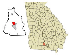
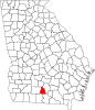
Adel is a city in and the county seat of Cook County, Georgia, United States, located fifty-two miles (84 km) southeast of Albany. As of the 2020 census, the city had a population of 5,571.

<span class="mw-page-title-main">Cecil, Georgia</span> Town in Georgia, United States

Cecil is a town in Cook County, Georgia, United States. The population was 286 at the 2010 census and 284 in 2020.

<span class="mw-page-title-main">Lenox, Georgia</span> Town in Georgia, United States

Lenox is a town in Cook County, Georgia, United States. The population was 752 at the 2020 census.

<span class="mw-page-title-main">Arabi, Georgia</span> Town in Georgia, United States

Arabi is a town in Crisp County, Georgia, United States. As of 2020 its population was 447.

<span class="mw-page-title-main">Cordele, Georgia</span> City in Georgia, United States

Cordele is a city in and the county seat of Crisp County, Georgia. The population was 11,165 at the 2010 census, and 10,220 in 2020.

<span class="mw-page-title-main">Chauncey, Georgia</span> City in Georgia, United States

Chauncey is a city in Dodge County, Georgia, United States. The population was 289 at the 2020 census. It was formed around station number twelve on the Macon and Brunswick Railroad.

<span class="mw-page-title-main">Dooling, Georgia</span> Town in Georgia, United States

Dooling is a town in Dooly County, Georgia, United States. The population was 68 at the 2020 census.

<span class="mw-page-title-main">Pinehurst, Georgia</span> City in Georgia, United States

Pinehurst is a city in Dooly County, Georgia, United States. The population was 309 in 2020.

<span class="mw-page-title-main">Siloam, Georgia</span> Town in Georgia, United States

Siloam is a town in Greene County, Georgia, United States. The population was 282 at the 2010 census, down from 331 in 2000.
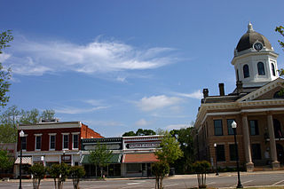
<span class="mw-page-title-main">Bowersville, Georgia</span> Town in Georgia, United States

Bowersville is a town in Hart County, Georgia, United States. As of the 2020 census, the town had a population of 444.

<span class="mw-page-title-main">Gray, Georgia</span> City in Georgia, United States

Gray is a city in Jones County, Georgia, United States. The population was 3,276 at the 2010 census, up from 1,811 at the 2000 census. In 2020, its population was 3,436. The city is the county seat of Jones County. It is part of the Macon metropolitan area.

<span class="mw-page-title-main">Dexter, Georgia</span> Town in Georgia, United States

Dexter is a town in Laurens County, Georgia, United States. As of 2020, its population was 655.

<span class="mw-page-title-main">Dearing, Georgia</span> Town in Georgia, United States

Dearing is a town in McDuffie County, Georgia, United States. The population was 529 at the 2020 census. It is part of the Augusta metropolitan area.

<span class="mw-page-title-main">Buckhead, Morgan County, Georgia</span> Town in Georgia, United States

Buckhead is a town in Morgan County, Georgia, United States. As of the 2020 census, the town had a population of 194.

<span class="mw-page-title-main">Soperton, Georgia</span> City in Georgia, United States

Soperton is a city in Treutlen County, Georgia, United States. The population was 2,889 in 2020. The city is the county seat of Treutlen County.

<span class="mw-page-title-main">Ashburn, Georgia</span> City in Georgia, United States

The city of Ashburn is the county seat of Turner County, Georgia, United States. As of 2020, its population was 4,291. Ashburn's government is classified as a council/manager form of municipal government.

<span class="mw-page-title-main">Pineview, Georgia</span> Town in Georgia, United States

Pineview is a town in Wilcox County, Georgia, United States. Per the 2020 census, the population was 454.

References

  1. "2020 U.S. Gazetteer Files". United States Census Bureau. Retrieved December 18, 2021.
  2. United States Postal Service (2012). "USPS - Look Up a ZIP Code" . Retrieved February 15, 2012.
  3. "U.S. Census website". United States Census Bureau . Retrieved January 31, 2008.
  4. "US Board on Geographic Names". United States Geological Survey. October 25, 2007. Retrieved January 31, 2008.
  5. 1 2 "Geographic Identifiers: 2010 Demographic Profile Data (G001): Sparks town, Georgia". U.S. Census Bureau, American Factfinder. Archived from the original on February 12, 2020. Retrieved July 30, 2014.
  6. 1 2 "Explore Census Data". data.census.gov. Retrieved December 18, 2021.
  7. "Post Offices". Jim Forte Postal History. Retrieved June 10, 2019.
  8. Krakow, Kenneth K. (1975). Georgia Place-Names: Their History and Origins (PDF). Macon, GA: Winship Press. p. 210. ISBN   0-915430-00-2.
  9. Huffard, R. Scott (2019). Engines of Redemption: Railroads and the Reconstruction of Capitalism in the New South. Chapel Hill: University of North Carolina Press. p. 57.
  10. "About Us". Adel-Cook County Chamber of Commerce. Archived from the original on March 7, 2018. Retrieved June 11, 2019.
  11. "US Gazetteer files: 2010, 2000, and 1990". United States Census Bureau. February 12, 2011. Retrieved April 23, 2011.
  12. "Census of Population and Housing". Census.gov. Retrieved June 4, 2015.